Axós elevation
Axós (Central Macedonia, Nomós Péllis), Greece elevation is 39 meters and Axós elevation in feet is 128 ft above sea level [src 1]. Axós is a populated place (feature code) with elevation that is 112 meters (367 ft) smaller than average city elevation in Greece.
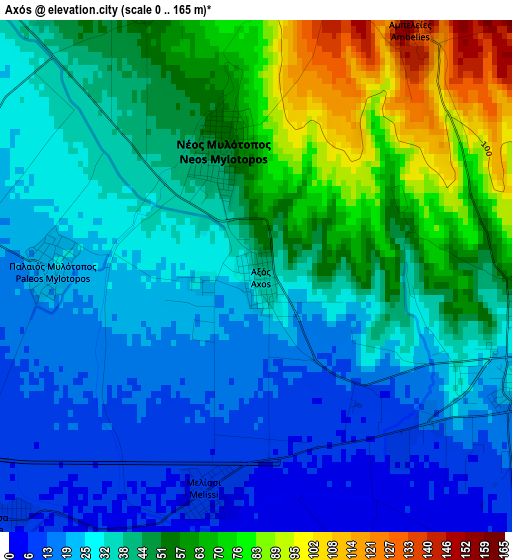
Below is the Elevation map of Axós, which displays elevation range with different colors. Scale of the first map is from 0 to 165 m (0 to 541 ft) with average elevation of 40.5 meters (=133 ft) [note 1]
These maps also provides idea of topography and contour of this city, they are displayed at different zoom levels. More info about maps, scale and edge coordinates you can find below images.
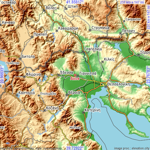
| \ | Map #1 | Topo.Map |
| Scale [m] | 0..165 m | × |
| Scale [ft] | 0..541 ft | × |
| Average | 40.5 m = 133 ft | × |
| Width | 7.4 km = 4.6 mi | 236.7 km = 147.1 mi |
| Height | 7.4 km = 4.6 mi | 236.7 km = 147.1 mi |
| ↑Max Latitude | 40.835487° | 41.85817° |
| Latitude at center | 40.80223° | 40.80223° |
| ↓Min Latitude | 40.768956° | 39.72922° |
| ← Min Longitude | 22.317635° | 20.95533° |
| Longitude center | 22.36158° | 22.36158° |
| →Max Longitude | 22.405525° | 23.76783° |
Nearby cities:
Cities around Axós sort by population:
• Giannitsá elevation 31 m
4 km,  106°
106°
• Néos Mylótopos 50 m
1.9 km,  342°
342°
• Galatádes 13 m
8.5 km,  232°
232°
• Karyótissa 9 m
5.5 km, 227°
• Ágios Loukás 9 m
10.9 km,  210°
210°
• Néa Pélla 33 m
11.7 km, 110°
• Aravissós 56 m
6.8 km,  312°
312°
• Palaífyto 16 m
7.7 km,  253°
253°
• Kalývia 19 m
13.2 km, 246°
• Ampeleíes 148 m
4.2 km,  31°
31°
• Melíssi 8 m
3.2 km,  192°
192°
• Pentaplátano 135 m
5.2 km,  68°
68°
Multilingual:
 En español:
Axós elevación 39 m.
 En France:
Axós élévation 39 m.


Sources and notes:
- [note 1] Map square and city borders are not equal. Map elevation data is calculated only from area inside that square.
- [src 1] Elevation data from geonames database provided with same terms of usage.
- [src 2] The elevation map of Axós is generated using elevation data from NASA's 3 arcsec (90m) resolution SRTM data.
- [src 3] Base (background) map © OpenStreetMap contributors tiles are generated by Geofabrik and OpenTopoMap.
Copyright & License:
This Axós Elevation Map is licensed under CC BY-SA. You may reuse any part from this page, if you give a proper credit by linking to this URL:
 More info on terms of use page.