Sérres elevation
Sérres (Central Macedonia, Nomós Serrón), Greece elevation is 41 meters and Sérres elevation in feet is 135 ft above sea level [src 1]. Sérres is a seat of a second-order administrative division (feature code) with elevation that is 110 meters (361 ft) smaller than average city elevation in Greece.
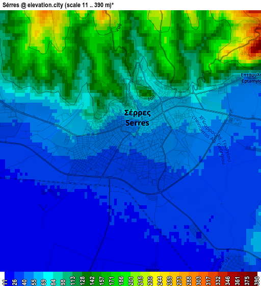
Below is the Elevation map of Sérres, which displays elevation range with different colors. Scale of the first map is from 11 to 390 m (36 to 1280 ft) with average elevation of 75.7 meters (=248 ft) [note 1]
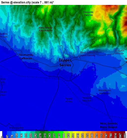
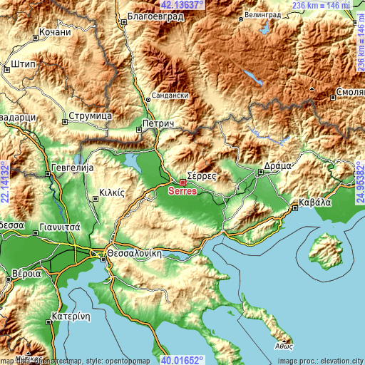
These maps also provides idea of topography and contour of this city, they are displayed at different zoom levels. More info about maps, scale and edge coordinates you can find below images.
| \ | Map #1 | Map #2 | Topo.Map |
| Scale [m] | 11..390 m | 7..881 m | × |
| Scale [ft] | 36..1280 ft | 23..2890 ft | × |
| Average | 75.7 m = 248 ft | 121.5 m = 399 ft | × |
| Width | 7.37 km = 4.6 mi | 14.73 km = 9.2 mi | 235.7 km = 146.5 mi |
| Height | 7.37 km = 4.6 mi | 14.73 km = 9.2 mi | 235.7 km = 146.5 mi |
| ↑Max Latitude | 41.118105° | 41.151203° | 42.13637° |
| Latitude at center | 41.08499° | 41.08499° | 41.08499° |
| ↓Min Latitude | 41.051859° | 41.01871° | 40.01652° |
| ← Min Longitude | 23.503625° | 23.459679° | 22.14132° |
| Longitude center | 23.54757° | 23.54757° | 23.54757° |
| →Max Longitude | 23.591515° | 23.635461° | 24.95382° |
Nearby cities:
Cities around Sérres sort by population:
• Néo Soúli elevation 156 m
8.1 km,  82°
82°
• Lefkónas 64 m
4.6 km,  291°
291°
• Skoútari 16 m
7.7 km,  197°
197°
• Néos Skopós 29 m
8.5 km,  142°
142°
• Chrysó 101 m
9.2 km,  109°
109°
• Mitroúsi 18 m
7.5 km,  257°
257°
• Skotoússa 28 m
14.7 km, 289°
• Ágio Pnévma 310 m
11.2 km, 80°
• Neochóri 33 m
4.5 km, 143°
• Kalá Déndra 22 m
10.5 km,  278°
278°
• Káto Kamíla 16 m
8.9 km,  217°
217°
• Provatás 22 m
13.3 km, 261°
Multilingual:
 En español:
Sérres elevación 41 m.
 En France:
Serrès élévation 41 m.


Sources and notes:
- [note 1] Map square and city borders are not equal. Map elevation data is calculated only from area inside that square.
- [src 1] Elevation data from geonames database provided with same terms of usage.
- [src 2] The elevation map of Sérres is generated using elevation data from NASA's 3 arcsec (90m) resolution SRTM data.
- [src 3] Base (background) map © OpenStreetMap contributors tiles are generated by Geofabrik and OpenTopoMap.
Copyright & License:
This Sérres Elevation Map is licensed under CC BY-SA. You may reuse any part from this page, if you give a proper credit by linking to this URL:
 More info on terms of use page.