Xánthi elevation
Xánthi (East Macedonia and Thrace, Nomós Xánthis), Greece elevation is 81 meters and Xánthi elevation in feet is 266 ft above sea level [src 1]. Xánthi is a seat of a second-order administrative division (feature code) with elevation that is 70 meters (230 ft) smaller than average city elevation in Greece.
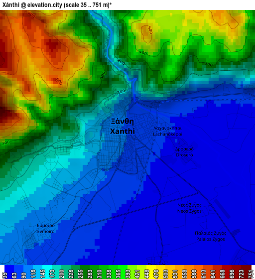
Below is the Elevation map of Xánthi, which displays elevation range with different colors. Scale of the first map is from 35 to 751 m (115 to 2464 ft) with average elevation of 201.4 meters (=661 ft) [note 1]
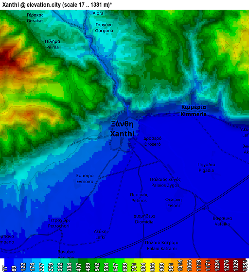
These maps also provides idea of topography and contour of this city, they are displayed at different zoom levels. More info about maps, scale and edge coordinates you can find below images.
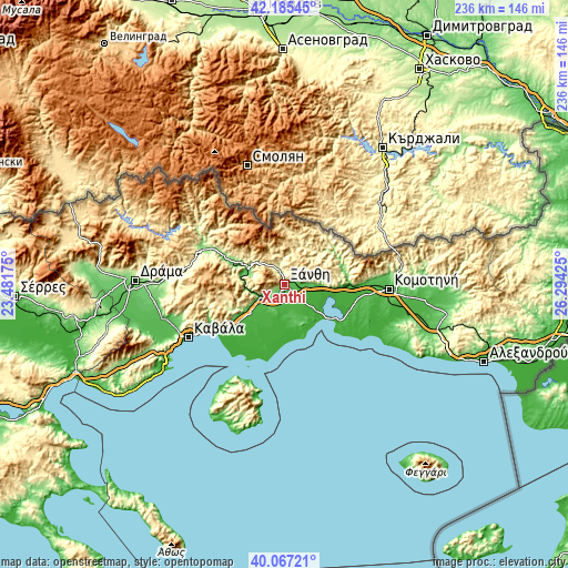
| \ | Map #1 | Map #2 | Topo.Map |
| Scale [m] | 35..751 m | 17..1381 m | × |
| Scale [ft] | 115..2464 ft | 56..4531 ft | × |
| Average | 201.4 m = 661 ft | 271.3 m = 890 ft | × |
| Width | 7.36 km = 4.6 mi | 14.72 km = 9.1 mi | 235.5 km = 146.3 mi |
| Height | 7.36 km = 4.6 mi | 14.72 km = 9.1 mi | 235.5 km = 146.3 mi |
| ↑Max Latitude | 41.16797° | 41.201043° | 42.18545° |
| Latitude at center | 41.13488° | 41.13488° | 41.13488° |
| ↓Min Latitude | 41.101774° | 41.068651° | 40.06721° |
| ← Min Longitude | 24.844055° | 24.800109° | 23.48175° |
| Longitude center | 24.888° | 24.888° | 24.888° |
| →Max Longitude | 24.931945° | 24.975891° | 26.29425° |
Nearby cities:
Cities around Xánthi sort by population:
• Kimméria elevation 77 m
4.5 km,  71°
71°
• Echínos 322 m
17.2 km,  24°
24°
• Sélero 72 m
8.9 km,  90°
90°
• Genisséa 26 m
10.3 km,  142°
142°
• Iliokentima 13 m
22.3 km,  202°
202°
• Ávato 15 m
20.4 km, 200°
• Mýki 357 m
12.4 km,  12°
12°
• Páchni 758 m
18.9 km,  1°
1°
• Petrochóri 65 m
6.6 km,  216°
216°
• Peteinós 44 m
3.9 km,  167°
167°
• Évlalo 18 m
18.4 km, 203°
• Smínthi 500 m
11.1 km,  350°
350°
Multilingual:
 En español:
Xánthi elevación 81 m.
 En France:
Xánthi élévation 81 m.


Sources and notes:
- [note 1] Map square and city borders are not equal. Map elevation data is calculated only from area inside that square.
- [src 1] Elevation data from geonames database provided with same terms of usage.
- [src 2] The elevation map of Xánthi is generated using elevation data from NASA's 3 arcsec (90m) resolution SRTM data.
- [src 3] Base (background) map © OpenStreetMap contributors tiles are generated by Geofabrik and OpenTopoMap.
Copyright & License:
This Xánthi Elevation Map is licensed under CC BY-SA. You may reuse any part from this page, if you give a proper credit by linking to this URL:
 More info on terms of use page.