Agnanteró elevation
Agnanteró (Thessaly, Nomós Kardhítsas), Greece elevation is 97 meters and Agnanteró elevation in feet is 318 ft above sea level [src 1]. Agnanteró is a populated place (feature code) with elevation that is 54 meters (177 ft) smaller than average city elevation in Greece.
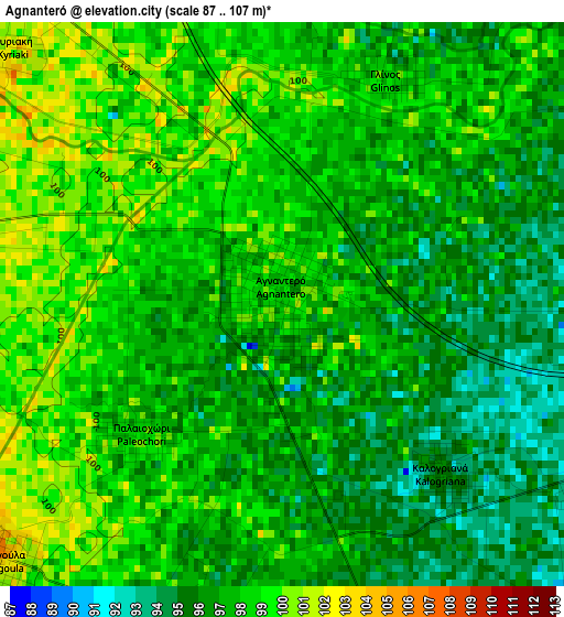
Below is the Elevation map of Agnanteró, which displays elevation range with different colors. Scale of the first map is from 87 to 107 m (285 to 351 ft) with average elevation of 97.2 meters (=319 ft) [note 1]
These maps also provides idea of topography and contour of this city, they are displayed at different zoom levels. More info about maps, scale and edge coordinates you can find below images.
| \ | Map #1 | Topo.Map |
| Scale [m] | 87..107 m | × |
| Scale [ft] | 285..351 ft | × |
| Average | 97.2 m = 319 ft | × |
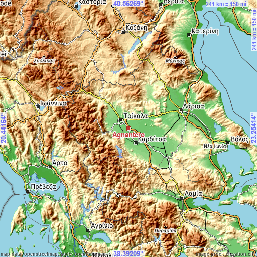
| Width | 7.54 km = 4.7 mi | 241.3 km = 149.9 mi |
| Height | 7.54 km = 4.7 mi | 241.3 km = 149.9 mi |
| ↑Max Latitude | 39.519768° | 40.56269° |
| Latitude at center | 39.48586° | 39.48586° |
| ↓Min Latitude | 39.451936° | 38.39209° |
| ← Min Longitude | 21.803945° | 20.44164° |
| Longitude center | 21.84789° | 21.84789° |
| →Max Longitude | 21.891835° | 23.25414° |
Nearby cities:
Cities around Agnanteró sort by population:
• Tríkala elevation 114 m
10.3 km,  318°
318°
• Karditsomagoúla 99 m
12.4 km,  148°
148°
• Megála Kalývia 106 m
5.3 km,  283°
283°
• Proástio 93 m
4.7 km,  88°
88°
• Megalochóri 104 m
8.2 km,  356°
356°
• Artesianó 97 m
10.2 km,  155°
155°
• Makrychóri 94 m
11.3 km,  116°
116°
• Pyrgetós 116 m
11.3 km,  311°
311°
• Pigí 120 m
12.9 km, 282°
• Taxiárches 96 m
10.7 km,  20°
20°
• Magoúla 102 m
5.2 km,  227°
227°
• Agía Triáda 94 m
5 km, 119°
Multilingual:
 En español:
Agnanteró elevación 97 m.
 En France:
Agnanteró élévation 97 m.
 Auf Deutsch:
Agnanteró höhe über dem Meeresspiegel ist 97 m.

Sources and notes:
- [note 1] Map square and city borders are not equal. Map elevation data is calculated only from area inside that square.
- [src 1] Elevation data from geonames database provided with same terms of usage.
- [src 2] The elevation map of Agnanteró is generated using elevation data from NASA's 3 arcsec (90m) resolution SRTM data.
- [src 3] Base (background) map © OpenStreetMap contributors tiles are generated by Geofabrik and OpenTopoMap.
Copyright & License:
This Agnanteró Elevation Map is licensed under CC BY-SA. You may reuse any part from this page, if you give a proper credit by linking to this URL:
 More info on terms of use page.