Fársala elevation
Fársala (Thessaly, Nomós Larísis), Greece elevation is 145 meters and Fársala elevation in feet is 476 ft above sea level [src 1]. Fársala is a seat of a third-order administrative division (feature code) with elevation that is 6 meters (20 ft) smaller than average city elevation in Greece.
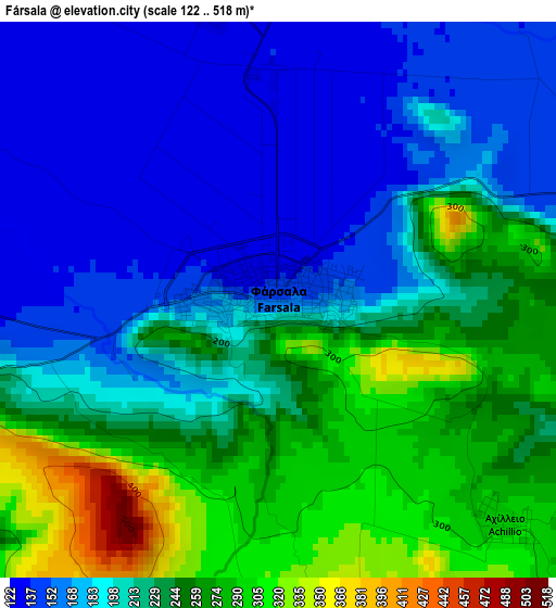
Below is the Elevation map of Fársala, which displays elevation range with different colors. Scale of the first map is from 122 to 518 m (400 to 1699 ft) with average elevation of 215.6 meters (=707 ft) [note 1]
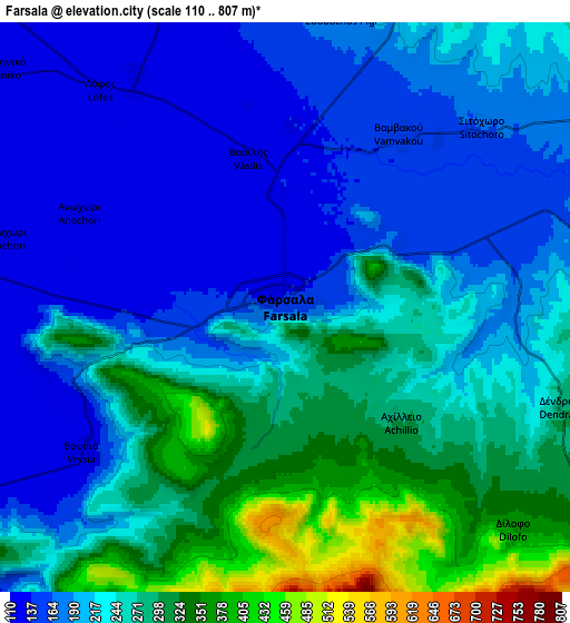
These maps also provides idea of topography and contour of this city, they are displayed at different zoom levels. More info about maps, scale and edge coordinates you can find below images.
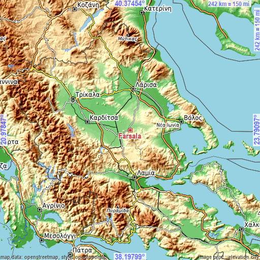
| \ | Map #1 | Map #2 | Topo.Map |
| Scale [m] | 122..518 m | 110..807 m | × |
| Scale [ft] | 400..1699 ft | 361..2648 ft | × |
| Average | 215.6 m = 707 ft | 228.4 m = 749 ft | × |
| Width | 7.56 km = 4.7 mi | 15.13 km = 9.4 mi | 242 km = 150.4 mi |
| Height | 7.56 km = 4.7 mi | 15.13 km = 9.4 mi | 242 km = 150.4 mi |
| ↑Max Latitude | 39.328721° | 39.362705° | 40.37454° |
| Latitude at center | 39.29472° | 39.29472° | 39.29472° |
| ↓Min Latitude | 39.260703° | 39.226669° | 38.19799° |
| ← Min Longitude | 22.340775° | 22.296829° | 20.97847° |
| Longitude center | 22.38472° | 22.38472° | 22.38472° |
| →Max Longitude | 22.428665° | 22.472611° | 23.79097° |
Nearby cities:
Cities around Fársala sort by population:
• Palamás elevation 92 m
32.2 km,  306°
306°
• Níkaia 89 m
31 km,  13°
13°
• Velestíno 112 m
32.6 km,  72°
72°
• Evxinoúpolis 78 m
32.8 km,  111°
111°
• Domokós 576 m
20 km,  201°
201°
• Itéa 97 m
26 km, 313°
• Omvriakí 560 m
23.6 km, 204°
• Néon Monastírion 117 m
11.3 km,  237°
237°
• Anávra 199 m
27.7 km,  245°
245°
• Vamvakoú 150 m
5.6 km,  32°
32°
• Karpochóri 111 m
32.4 km,  278°
278°
• Sofádes 110 m
24.9 km, 279°
Multilingual:
 En español:
Farsalia elevación 145 m.
 En France:
Pharsale élévation 145 m.


Sources and notes:
- [note 1] Map square and city borders are not equal. Map elevation data is calculated only from area inside that square.
- [src 1] Elevation data from geonames database provided with same terms of usage.
- [src 2] The elevation map of Fársala is generated using elevation data from NASA's 3 arcsec (90m) resolution SRTM data.
- [src 3] Base (background) map © OpenStreetMap contributors tiles are generated by Geofabrik and OpenTopoMap.
Copyright & License:
This Fársala Elevation Map is licensed under CC BY-SA. You may reuse any part from this page, if you give a proper credit by linking to this URL:
 More info on terms of use page.