Ligourión elevation
Ligourión (Peloponnese, Nomós Argolídos), Greece elevation is 348 meters and Ligourión elevation in feet is 1142 ft above sea level [src 1]. Ligourión is a populated place (feature code) with elevation that is 197 meters (646 ft) bigger than average city elevation in Greece.
Below is the Elevation map of Ligourión, which displays elevation range with different colors. Scale of the first map is from 162 to 1121 m (531 to 3678 ft) with average elevation of 433.1 meters (=1421 ft) [note 1]
These maps also provides idea of topography and contour of this city, they are displayed at different zoom levels. More info about maps, scale and edge coordinates you can find below images.
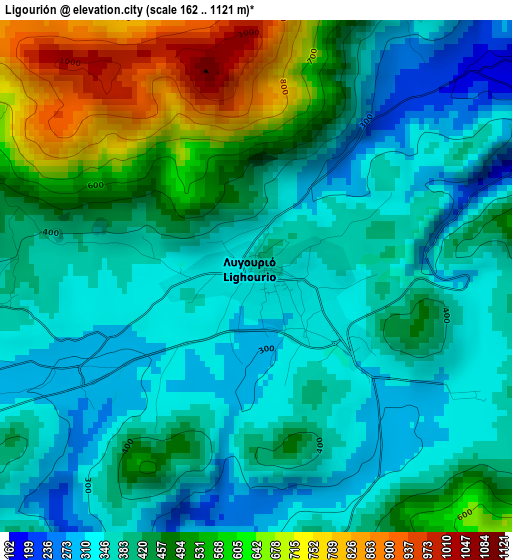
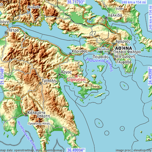
| \ | Map #1 | Topo.Map |
| Scale [m] | 162..1121 m | × |
| Scale [ft] | 531..3678 ft | × |
| Average | 433.1 m = 1421 ft | × |
| Width | 7.74 km = 4.8 mi | 247.7 km = 153.9 mi |
| Height | 7.74 km = 4.8 mi | 247.7 km = 153.9 mi |
| ↑Max Latitude | 37.647133° | 38.71793° |
| Latitude at center | 37.61233° | 37.61233° |
| ↓Min Latitude | 37.57751° | 36.49004° |
| ← Min Longitude | 22.993785° | 21.63148° |
| Longitude center | 23.03773° | 23.03773° |
| →Max Longitude | 23.081675° | 24.44398° |
Nearby cities:
Cities around Ligourión sort by population:
• Náfplio elevation 5 m
20.9 km,  256°
256°
• Aria 23 m
18.3 km, 256°
• Sofikón 430 m
20.3 km,  3°
3°
• Palaiá Epídavros 10 m
10.8 km,  74°
74°
• Tolón 10 m
18.8 km,  237°
237°
• Drépanon 10 m
15.1 km, 237°
• Néa Tírins 36 m
19.2 km,  268°
268°
• Koilás 6 m
23.6 km,  160°
160°
• Ayía Triás 21 m
20.7 km,  277°
277°
• Áyios Adhrianós 70 m
17 km, 265°
• Asíni 29 m
17 km, 243°
• Dídyma 151 m
20.4 km,  144°
144°
Multilingual:
 En español:
Ligourión elevación 348 m.
 En France:
Ligourión élévation 348 m.
 Auf Deutsch:
Ligourión höhe über dem Meeresspiegel ist 348 m.

Sources and notes:
- [note 1] Map square and city borders are not equal. Map elevation data is calculated only from area inside that square.
- [src 1] Elevation data from geonames database provided with same terms of usage.
- [src 2] The elevation map of Ligourión is generated using elevation data from NASA's 3 arcsec (90m) resolution SRTM data.
- [src 3] Base (background) map © OpenStreetMap contributors tiles are generated by Geofabrik and OpenTopoMap.
Copyright & License:
This Ligourión Elevation Map is licensed under CC BY-SA. You may reuse any part from this page, if you give a proper credit by linking to this URL:
 More info on terms of use page.