Mesolóngi elevation
Mesolóngi (West Greece, Nomós Aitolías kai Akarnanías), Greece elevation is 3 meters and Mesolóngi elevation in feet is 10 ft above sea level [src 1]. Mesolóngi is a seat of a second-order administrative division (feature code) with elevation that is 148 meters (486 ft) smaller than average city elevation in Greece.
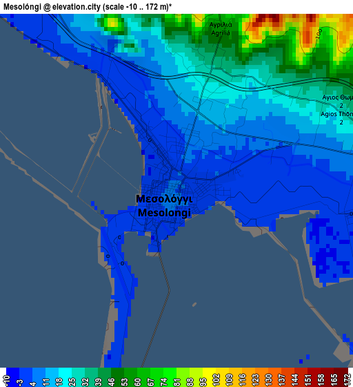
Below is the Elevation map of Mesolóngi, which displays elevation range with different colors. Scale of the first map is from -10 to 172 m (-33 to 564 ft) with average elevation of 19 meters (=62 ft) [note 1]
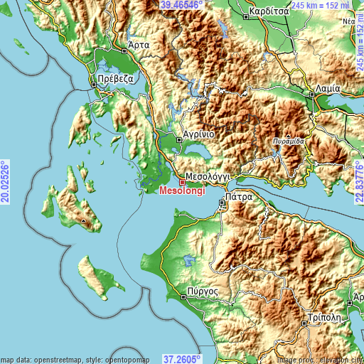
These maps also provides idea of topography and contour of this city, they are displayed at different zoom levels. More info about maps, scale and edge coordinates you can find below images.
| \ | Map #1 | Map #2 | Topo.Map |
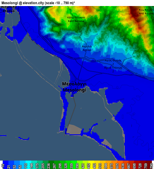
| Scale [m] | -10..172 m | -10..790 m | × |
| Scale [ft] | -33..564 ft | -33..2592 ft | × |
| Average | 19 m = 62 ft | 126.7 m = 416 ft | × |
| Width | 7.66 km = 4.8 mi | 15.32 km = 9.5 mi | 245.2 km = 152.4 mi |
| Height | 7.66 km = 4.8 mi | 15.32 km = 9.5 mi | 245.2 km = 152.4 mi |
| ↑Max Latitude | 38.405825° | 38.440254° | 39.46546° |
| Latitude at center | 38.37138° | 38.37138° | 38.37138° |
| ↓Min Latitude | 38.336919° | 38.302441° | 37.2605° |
| ← Min Longitude | 21.387565° | 21.343619° | 20.02526° |
| Longitude center | 21.43151° | 21.43151° | 21.43151° |
| →Max Longitude | 21.475455° | 21.519401° | 22.83776° |
Nearby cities:
Cities around Mesolóngi sort by population:
• Káto Achaḯa elevation 0 m
26.7 km,  157°
157°
• Aitolikó 4 m
10 km,  317°
317°
• Panaitólion 42 m
23.6 km,  3°
3°
• Katochí 7 m
16.2 km,  286°
286°
• Neochórion 6 m
14.2 km, 286°
• Kainoúryion 41 m
26.4 km,  10°
10°
• Mataránga 114 m
17.3 km, 12°
• Angelókastro 68 m
24.6 km,  331°
331°
• Limnokhórion 25 m
26 km,  170°
170°
• Pappadhátai 76 m
17.5 km, 5°
• Galatás 10 m
11.5 km,  97°
97°
• Gavaloú 45 m
19.6 km,  26°
26°
Multilingual:
 En español:
Mesolóngi elevación 3 m.
 En France:
Mesolóngi élévation 3 m.


Sources and notes:
- [note 1] Map square and city borders are not equal. Map elevation data is calculated only from area inside that square.
- [src 1] Elevation data from geonames database provided with same terms of usage.
- [src 2] The elevation map of Mesolóngi is generated using elevation data from NASA's 3 arcsec (90m) resolution SRTM data.
- [src 3] Base (background) map © OpenStreetMap contributors tiles are generated by Geofabrik and OpenTopoMap.
Copyright & License:
This Mesolóngi Elevation Map is licensed under CC BY-SA. You may reuse any part from this page, if you give a proper credit by linking to this URL:
 More info on terms of use page.