Mokhós elevation
Mokhós (Crete, Nomós Irakleíou), Greece elevation is 398 meters and Mokhós elevation in feet is 1306 ft above sea level [src 1]. Mokhós is a populated place (feature code) with elevation that is 247 meters (810 ft) bigger than average city elevation in Greece.
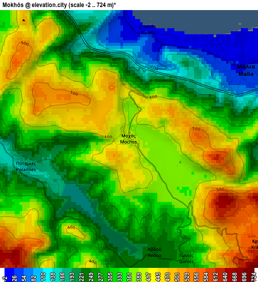
Below is the Elevation map of Mokhós, which displays elevation range with different colors. Scale of the first map is from -2 to 724 m (-7 to 2375 ft) with average elevation of 328.1 meters (=1076 ft) [note 1]
These maps also provides idea of topography and contour of this city, they are displayed at different zoom levels. More info about maps, scale and edge coordinates you can find below images.
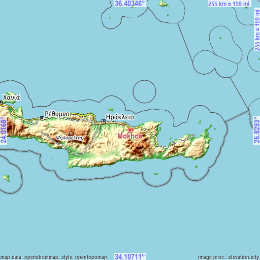
| \ | Map #1 | Topo.Map |
| Scale [m] | -2..724 m | × |
| Scale [ft] | -7..2375 ft | × |
| Average | 328.1 m = 1076 ft | × |
| Width | 7.98 km = 5 mi | 255.3 km = 158.6 mi |
| Height | 7.98 km = 5 mi | 255.3 km = 158.6 mi |
| ↑Max Latitude | 35.299294° | 36.40346° |
| Latitude at center | 35.26342° | 35.26342° |
| ↓Min Latitude | 35.22753° | 34.10711° |
| ← Min Longitude | 25.379105° | 24.0168° |
| Longitude center | 25.42305° | 25.42305° |
| →Max Longitude | 25.466995° | 26.8293° |
Nearby cities:
Cities around Mokhós sort by population:
• Mália elevation 28 m
4.2 km,  57°
57°
• Arkalochóri 386 m
19.4 km,  227°
227°
• Limín Khersonísou 1 m
7.2 km,  337°
337°
• Neápoli 262 m
16.5 km,  92°
92°
• Káto Goúves 15 m
12.3 km,  306°
306°
• Kastélli 338 m
9.8 km, 232°
• Kokkíni Cháni 12 m
16.6 km,  295°
295°
• Goúrnes 17 m
15 km, 297°
• Thrapsanón 350 m
15.4 km,  236°
236°
• Stalís 5 m
3.4 km,  15°
15°
• Skalánion 242 m
21.5 km,  275°
275°
• Sísion 14 m
10.1 km, 60°
Multilingual:
 En español:
Mokhós elevación 398 m.
 En France:
Mokhós élévation 398 m.


Sources and notes:
- [note 1] Map square and city borders are not equal. Map elevation data is calculated only from area inside that square.
- [src 1] Elevation data from geonames database provided with same terms of usage.
- [src 2] The elevation map of Mokhós is generated using elevation data from NASA's 3 arcsec (90m) resolution SRTM data.
- [src 3] Base (background) map © OpenStreetMap contributors tiles are generated by Geofabrik and OpenTopoMap.
Copyright & License:
This Mokhós Elevation Map is licensed under CC BY-SA. You may reuse any part from this page, if you give a proper credit by linking to this URL:
 More info on terms of use page.