Monastiráki elevation
Monastiráki (West Greece, Nomós Aitolías kai Akarnanías), Greece elevation is 281 meters and Monastiráki elevation in feet is 922 ft above sea level [src 1]. Monastiráki is a populated place (feature code) with elevation that is 130 meters (427 ft) bigger than average city elevation in Greece.
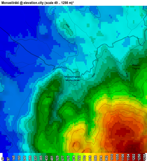
Below is the Elevation map of Monastiráki, which displays elevation range with different colors. Scale of the first map is from 49 to 1298 m (161 to 4259 ft) with average elevation of 397.7 meters (=1305 ft) [note 1]
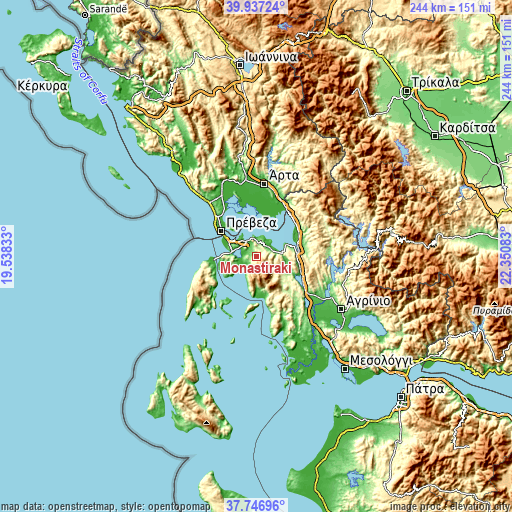
These maps also provides idea of topography and contour of this city, they are displayed at different zoom levels. More info about maps, scale and edge coordinates you can find below images.
| \ | Map #1 | Topo.Map |
| Scale [m] | 49..1298 m | × |
| Scale [ft] | 161..4259 ft | × |
| Average | 397.7 m = 1305 ft | × |
| Width | 7.61 km = 4.7 mi | 243.5 km = 151.3 mi |
| Height | 7.61 km = 4.7 mi | 243.5 km = 151.3 mi |
| ↑Max Latitude | 38.884746° | 39.93724° |
| Latitude at center | 38.85053° | 38.85053° |
| ↓Min Latitude | 38.816298° | 37.74696° |
| ← Min Longitude | 20.900635° | 19.53833° |
| Longitude center | 20.94458° | 20.94458° |
| →Max Longitude | 20.988525° | 22.35083° |
Nearby cities:
Cities around Monastiráki sort by population:
• Préveza elevation 9 m
20.5 km,  304°
304°
• Lefkáda 8 m
20.9 km,  263°
263°
• Vónitsa 0 m
8.9 km,  325°
325°
• Amfilochía 80 m
19.2 km,  87°
87°
• Pálairos 29 m
9.3 km,  215°
215°
• Katoúna 332 m
16.4 km,  116°
116°
• Neochóri 3 m
25.3 km,  14°
14°
• Kríkellos 17 m
22.9 km,  62°
62°
• Kandíla 55 m
16.1 km,  179°
179°
• Archontochóri 429 m
18.6 km,  153°
153°
• Stános 102 m
20.6 km,  104°
104°
• Sardínia 93 m
23.1 km,  79°
79°
Multilingual:
 En español:
Monastiráki elevación 281 m.
 En France:
Monastiráki élévation 281 m.
 Auf Deutsch:
Monastiráki höhe über dem Meeresspiegel ist 281 m.

Sources and notes:
- [note 1] Map square and city borders are not equal. Map elevation data is calculated only from area inside that square.
- [src 1] Elevation data from geonames database provided with same terms of usage.
- [src 2] The elevation map of Monastiráki is generated using elevation data from NASA's 3 arcsec (90m) resolution SRTM data.
- [src 3] Base (background) map © OpenStreetMap contributors tiles are generated by Geofabrik and OpenTopoMap.
Copyright & License:
This Monastiráki Elevation Map is licensed under CC BY-SA. You may reuse any part from this page, if you give a proper credit by linking to this URL:
 More info on terms of use page.