Perivóli elevation
Perivóli (Ionian Islands, Nomós Kerkýras), Greece elevation is 41 meters and Perivóli elevation in feet is 135 ft above sea level [src 1]. Perivóli is a populated place (feature code) with elevation that is 110 meters (361 ft) smaller than average city elevation in Greece.
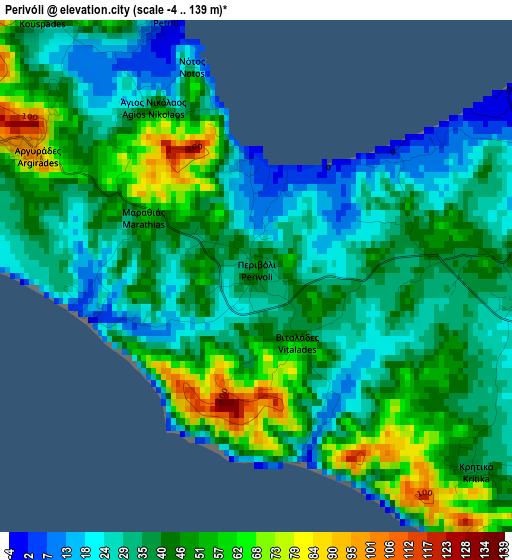
Below is the Elevation map of Perivóli, which displays elevation range with different colors. Scale of the first map is from -4 to 139 m (-13 to 456 ft) with average elevation of 40 meters (=131 ft) [note 1]
These maps also provides idea of topography and contour of this city, they are displayed at different zoom levels. More info about maps, scale and edge coordinates you can find below images.
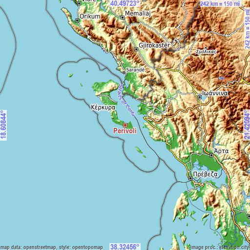
| \ | Map #1 | Topo.Map |
| Scale [m] | -4..139 m | × |
| Scale [ft] | -13..456 ft | × |
| Average | 40 m = 131 ft | × |
| Width | 7.55 km = 4.7 mi | 241.6 km = 150.1 mi |
| Height | 7.55 km = 4.7 mi | 241.6 km = 150.1 mi |
| ↑Max Latitude | 39.4533° | 40.49723° |
| Latitude at center | 39.41936° | 39.41936° |
| ↓Min Latitude | 39.385403° | 38.32456° |
| ← Min Longitude | 19.970745° | 18.60844° |
| Longitude center | 20.01469° | 20.01469° |
| →Max Longitude | 20.058635° | 21.42094° |
Nearby cities:
Cities around Perivóli sort by population:
• Corfu elevation 15 m
23.8 km,  340°
340°
• Igoumenítsa 29 m
23.6 km,  66°
66°
• Kanáli 16 m
23.2 km,  333°
333°
• Alepoú 16 m
24.1 km, 334°
• Lefkímmi 21 m
4.9 km,  84°
84°
• Graikochóri 52 m
24.1 km, 68°
• Néa Seléfkeia 36 m
23.7 km,  60°
60°
• Virós 107 m
21.5 km, 328°
• Ágios Matthaíos 112 m
14.8 km,  304°
304°
• Kynopiástes 68 m
20 km, 325°
• Platariá 2 m
22.9 km, 81°
• Perama 60 m
20.2 km, 334°
Multilingual:
 En español:
Perivóli elevación 41 m.
 En France:
Perivóli élévation 41 m.


Sources and notes:
- [note 1] Map square and city borders are not equal. Map elevation data is calculated only from area inside that square.
- [src 1] Elevation data from geonames database provided with same terms of usage.
- [src 2] The elevation map of Perivóli is generated using elevation data from NASA's 3 arcsec (90m) resolution SRTM data.
- [src 3] Base (background) map © OpenStreetMap contributors tiles are generated by Geofabrik and OpenTopoMap.
Copyright & License:
This Perivóli Elevation Map is licensed under CC BY-SA. You may reuse any part from this page, if you give a proper credit by linking to this URL:
 More info on terms of use page.