Evinayong elevation
Evinayong (Centro Sur), Equatorial Guinea elevation is 669 meters and Evinayong elevation in feet is 2195 ft above sea level [src 1]. Evinayong is a seat of a first-order administrative division (feature code) with elevation that is 323 meters (1060 ft) bigger than average city elevation in Equatorial Guinea.
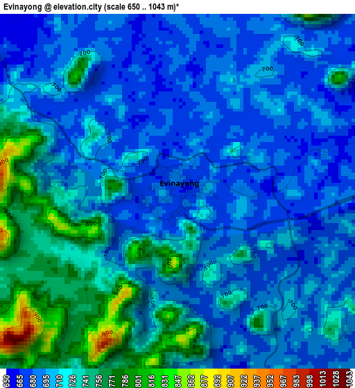
Below is the Elevation map of Evinayong, which displays elevation range with different colors. Scale of the first map is from 650 to 1043 m (2133 to 3422 ft) with average elevation of 709.5 meters (=2328 ft) [note 1]
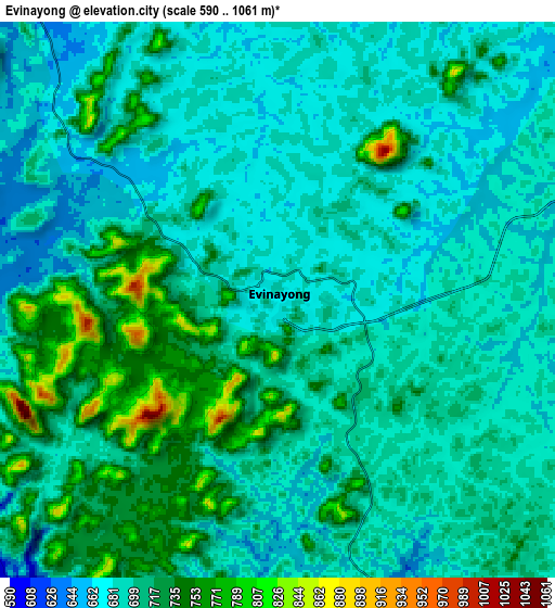
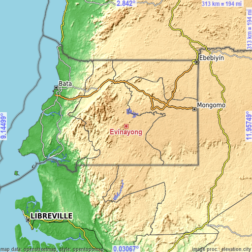
These maps also provides idea of topography and contour of this city, they are displayed at different zoom levels. More info about maps, scale and edge coordinates you can find below images.
| \ | Map #1 | Map #2 | Topo.Map |
| Scale [m] | 650..1043 m | 590..1061 m | × |
| Scale [ft] | 2133..3422 ft | 1936..3481 ft | × |
| Average | 709.5 m = 2328 ft | 699.1 m = 2294 ft | × |
| Width | 9.77 km = 6.1 mi | 19.54 km = 12.1 mi | 312.6 km = 194.2 mi |
| Height | 9.77 km = 6.1 mi | 19.54 km = 12.1 mi | 312.6 km = 194.2 mi |
| ↑Max Latitude | 1.480701° | 1.524631° | 2.842° |
| Latitude at center | 1.43677° | 1.43677° | 1.43677° |
| ↓Min Latitude | 1.392838° | 1.348905° | 0.03067° |
| ← Min Longitude | 10.507295° | 10.463349° | 9.14499° |
| Longitude center | 10.55124° | 10.55124° | 10.55124° |
| →Max Longitude | 10.595185° | 10.639131° | 11.95749° |
Nearby cities:
Cities around Evinayong sort by population:
• Bata elevation 13 m
99.4 km,  298°
298°
• Aconibe 683 m
45.6 km,  109°
109°
• Añisoc 456 m
53.5 km,  26°
26°
• Mongomo 630 m
87.3 km,  75°
75°
• Mikomeseng 542 m
78.1 km,  5°
5°
• Nsok 552 m
86.5 km, 113°
• Ayene 443 m
49.1 km,  18°
18°
• Machinda 174 m
83.1 km,  306°
306°
• Acurenam 661 m
46.3 km,  166°
166°
• Bicurga 641 m
18.6 km,  329°
329°
• Nsang 589 m
78.7 km, 33°
• Ncue 399 m
65.1 km,  352°
352°
Multilingual:
 En español:
Evinayong elevación 669 m.
 En France:
Evinayong élévation 669 m.
 Auf Deutsch:
Evinayong höhe über dem Meeresspiegel ist 669 m.

Sources and notes:
- [note 1] Map square and city borders are not equal. Map elevation data is calculated only from area inside that square.
- [src 1] Elevation data from geonames database provided with same terms of usage.
- [src 2] The elevation map of Evinayong is generated using elevation data from NASA's 3 arcsec (90m) resolution SRTM data.
- [src 3] Base (background) map © OpenStreetMap contributors tiles are generated by Geofabrik and OpenTopoMap.
Copyright & License:
This Evinayong Elevation Map is licensed under CC BY-SA. You may reuse any part from this page, if you give a proper credit by linking to this URL:
 More info on terms of use page.