Pointe-à-Pitre elevation
Pointe-à-Pitre (Guadeloupe), Guadeloupe elevation is 15 meters and Pointe-à-Pitre elevation in feet is 49 ft above sea level [src 1]. Pointe-à-Pitre is a populated place (feature code) with elevation that is 34 meters (112 ft) smaller than average city elevation in Guadeloupe.
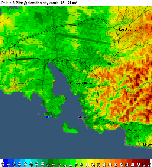
Below is the Elevation map of Pointe-à-Pitre, which displays elevation range with different colors. Scale of the first map is from -45 to 71 m (-148 to 233 ft) with average elevation of 16.9 meters (=55 ft) [note 1]
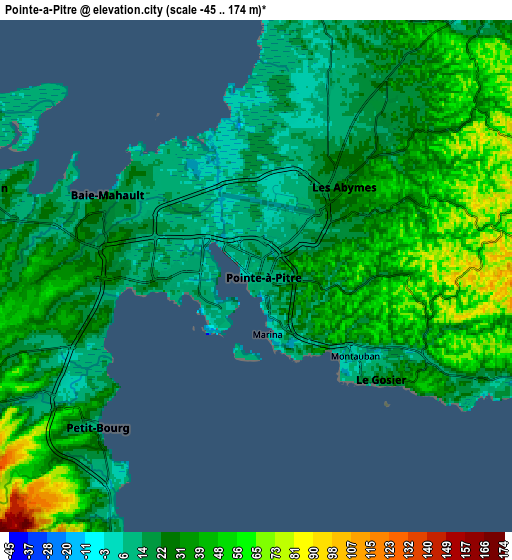
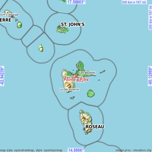
These maps also provides idea of topography and contour of this city, they are displayed at different zoom levels. More info about maps, scale and edge coordinates you can find below images.
| \ | Map #1 | Map #2 | Topo.Map |
| Scale [m] | -45..71 m | -45..174 m | × |
| Scale [ft] | -148..233 ft | -148..571 ft | × |
| Average | 16.9 m = 55 ft | 30.9 m = 101 ft | × |
| Width | 9.38 km = 5.8 mi | 18.77 km = 11.7 mi | 300.2 km = 186.5 mi |
| Height | 9.38 km = 5.8 mi | 18.77 km = 11.7 mi | 300.2 km = 186.5 mi |
| ↑Max Latitude | 16.283437° | 16.325615° | 17.58663° |
| Latitude at center | 16.24125° | 16.24125° | 16.24125° |
| ↓Min Latitude | 16.199054° | 16.156849° | 14.8866° |
| ← Min Longitude | -61.580085° | -61.624031° | -62.94239° |
| Longitude center | -61.53614° | -61.53614° | -61.53614° |
| →Max Longitude | -61.492195° | -61.448249° | -60.12989° |
Nearby cities:
Cities around Pointe-à-Pitre sort by population:
• Les Abymes elevation 20 m
4.8 km,  43°
43°
• Baie-Mahault 18 m
6 km,  298°
298°
• Le Gosier 24 m
6 km,  130°
130°
• Petit-Bourg 7 m
8.1 km,  226°
226°
• Sainte-Anne 3 m
16.7 km,  95°
95°
• Le Moule 8 m
22.6 km,  63°
63°
• Sainte-Rose 22 m
19.9 km, 300°
• Capesterre-Belle-Eau 17 m
22 km,  187°
187°
• Lamentin 10 m
10.7 km,  287°
287°
• Petit-Canal 16 m
16.2 km,  18°
18°
• Port-Louis 6 m
19.6 km,  1°
1°
• Anse-Bertrand 17 m
25.9 km,  6°
6°
Multilingual:
 En español:
Pointe-à-Pitre elevación 15 m.
 En France:
Pointe-à-Pitre élévation 15 m.
 Auf Deutsch:
Pointe-à-Pitre, Pointe a Pitre höhe über dem Meeresspiegel ist 15 m.

Sources and notes:
- [note 1] Map square and city borders are not equal. Map elevation data is calculated only from area inside that square.
- [src 1] Elevation data from geonames database provided with same terms of usage.
- [src 2] The elevation map of Pointe-à-Pitre is generated using elevation data from NASA's 3 arcsec (90m) resolution SRTM data.
- [src 3] Base (background) map © OpenStreetMap contributors tiles are generated by Geofabrik and OpenTopoMap.
Copyright & License:
This Pointe-à-Pitre Elevation Map is licensed under CC BY-SA. You may reuse any part from this page, if you give a proper credit by linking to this URL:
 More info on terms of use page.