Coyah elevation
Coyah (Kindia), Guinea elevation is 13 meters and Coyah elevation in feet is 43 ft above sea level [src 1]. Coyah is a seat of a second-order administrative division (feature code) with elevation that is 420 meters (1378 ft) smaller than average city elevation in Guinea.
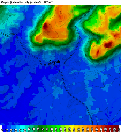
Below is the Elevation map of Coyah, which displays elevation range with different colors. Scale of the first map is from -9 to 527 m (-30 to 1729 ft) with average elevation of 90.5 meters (=297 ft) [note 1]
These maps also provides idea of topography and contour of this city, they are displayed at different zoom levels. More info about maps, scale and edge coordinates you can find below images.
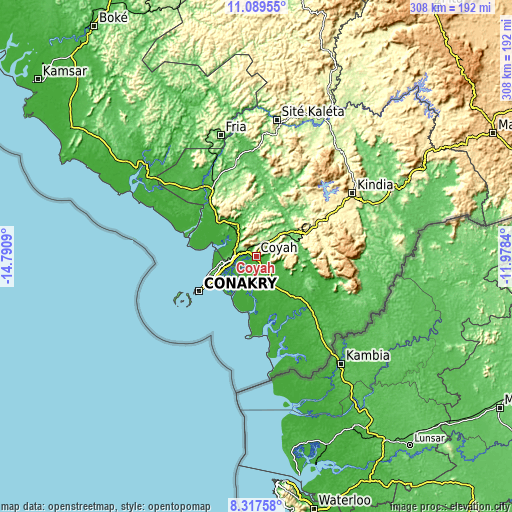
| \ | Map #1 | Map #2 | Topo.Map |
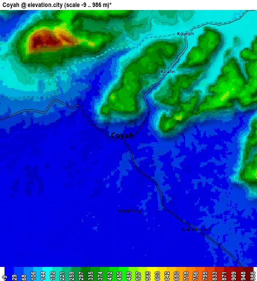
| Scale [m] | -9..527 m | -9..986 m | × |
| Scale [ft] | -30..1729 ft | -30..3235 ft | × |
| Average | 90.5 m = 297 ft | 122.1 m = 401 ft | × |
| Width | 9.63 km = 6 mi | 19.27 km = 12 mi | 308.2 km = 191.5 mi |
| Height | 9.63 km = 6 mi | 19.27 km = 12 mi | 308.2 km = 191.5 mi |
| ↑Max Latitude | 9.749743° | 9.793051° | 11.08955° |
| Latitude at center | 9.70643° | 9.70643° | 9.70643° |
| ↓Min Latitude | 9.663111° | 9.619786° | 8.31758° |
| ← Min Longitude | -13.428595° | -13.472541° | -14.7909° |
| Longitude center | -13.38465° | -13.38465° | -13.38465° |
| →Max Longitude | -13.340705° | -13.296759° | -11.9784° |
Nearby cities:
Cities around Coyah sort by population:
• Camayenne elevation 6 m
38.3 km,  240°
240°
• Conakry 13 m
37.1 km, 239°
• Kindia 415 m
68.9 km,  55°
55°
• Fria 210 m
76.6 km,  343°
343°
• Mamou 720 m
159.9 km, 62°
• Télimélé 610 m
138.2 km,  16°
16°
• Forécariah 32 m
44.7 km,  133°
133°
• Tondon 113 m
73.5 km,  2°
2°
• Dubréka 19 m
17.9 km,  301°
301°
• Kimbo 262 m
79.2 km,  346°
346°
• Sanguéya 18 m
154.1 km,  315°
315°
• Boffa 0 m
87.6 km,  305°
305°
Multilingual:
 En español:
Coyah elevación 13 m.
 En France:
Coyah élévation 13 m.


Sources and notes:
- [note 1] Map square and city borders are not equal. Map elevation data is calculated only from area inside that square.
- [src 1] Elevation data from geonames database provided with same terms of usage.
- [src 2] The elevation map of Coyah is generated using elevation data from NASA's 3 arcsec (90m) resolution SRTM data.
- [src 3] Base (background) map © OpenStreetMap contributors tiles are generated by Geofabrik and OpenTopoMap.
Copyright & License:
This Coyah Elevation Map is licensed under CC BY-SA. You may reuse any part from this page, if you give a proper credit by linking to this URL:
 More info on terms of use page.