Tokonou elevation
Tokonou (Kankan, Kankan Prefecture), Guinea elevation is 562 meters and Tokonou elevation in feet is 1844 ft above sea level [src 1]. Tokonou is a populated place (feature code) with elevation that is 129 meters (423 ft) bigger than average city elevation in Guinea.
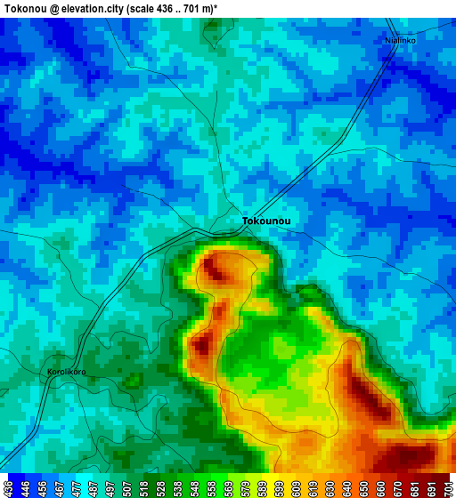
Below is the Elevation map of Tokonou, which displays elevation range with different colors. Scale of the first map is from 436 to 701 m (1430 to 2300 ft) with average elevation of 500.7 meters (=1643 ft) [note 1]
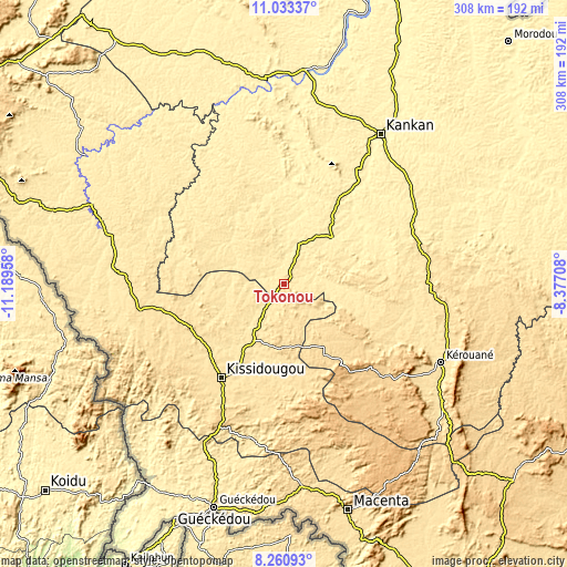
These maps also provides idea of topography and contour of this city, they are displayed at different zoom levels. More info about maps, scale and edge coordinates you can find below images.
| \ | Map #1 | Map #2 | Topo.Map |
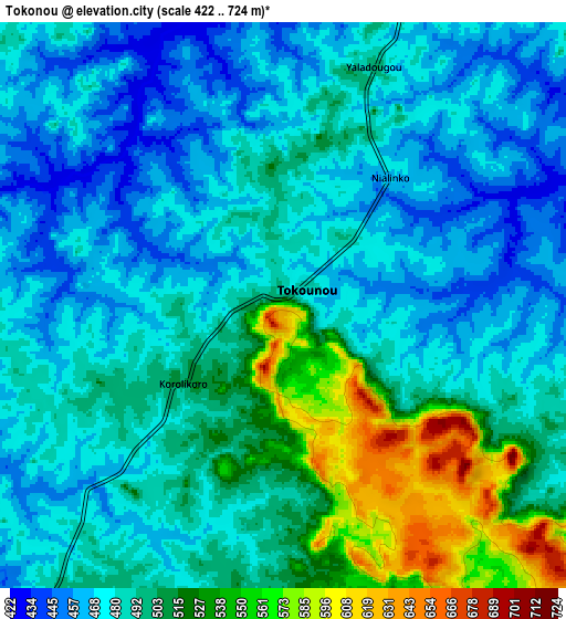
| Scale [m] | 436..701 m | 422..724 m | × |
| Scale [ft] | 1430..2300 ft | 1385..2375 ft | × |
| Average | 500.7 m = 1643 ft | 491.8 m = 1614 ft | × |
| Width | 9.63 km = 6 mi | 19.27 km = 12 mi | 308.3 km = 191.6 mi |
| Height | 9.63 km = 6 mi | 19.27 km = 12 mi | 308.3 km = 191.6 mi |
| ↑Max Latitude | 9.693321° | 9.736636° | 11.03337° |
| Latitude at center | 9.65° | 9.65° | 9.65° |
| ↓Min Latitude | 9.606674° | 9.563342° | 8.26093° |
| ← Min Longitude | -9.827275° | -9.871221° | -11.18958° |
| Longitude center | -9.78333° | -9.78333° | -9.78333° |
| →Max Longitude | -9.739385° | -9.695439° | -8.37708° |
Nearby cities:
Cities around Tokonou sort by population:
• Kankan elevation 381 m
97.1 km,  32°
32°
• Gueckedou 430 m
126.4 km,  197°
197°
• Kissidougou 530 m
62.3 km,  213°
213°
• Siguiri 368 m
208.3 km,  18°
18°
• Macenta 546 m
127.7 km,  164°
164°
• Kouroussa 383 m
111.7 km,  354°
354°
• Dabola 434 m
189.2 km,  309°
309°
• Beyla 684 m
164 km,  130°
130°
• Mandiana 373 m
161.2 km,  47°
47°
• Faranah 433 m
113.8 km,  292°
292°
• Kérouané 533 m
94.3 km,  116°
116°
• Dinguiraye 432 m
208.8 km,  330°
330°
Multilingual:
 En español:
Tokonou elevación 562 m.
 En France:
Tokonou élévation 562 m.


Sources and notes:
- [note 1] Map square and city borders are not equal. Map elevation data is calculated only from area inside that square.
- [src 1] Elevation data from geonames database provided with same terms of usage.
- [src 2] The elevation map of Tokonou is generated using elevation data from NASA's 3 arcsec (90m) resolution SRTM data.
- [src 3] Base (background) map © OpenStreetMap contributors tiles are generated by Geofabrik and OpenTopoMap.
Copyright & License:
This Tokonou Elevation Map is licensed under CC BY-SA. You may reuse any part from this page, if you give a proper credit by linking to this URL:
 More info on terms of use page.