Georgetown elevation
Georgetown (Central River), Gambia elevation is 7 meters and Georgetown elevation in feet is 23 ft above sea level [src 1]. Georgetown is a seat of a first-order administrative division (feature code) with elevation that is 14 meters (46 ft) smaller than average city elevation in Gambia.
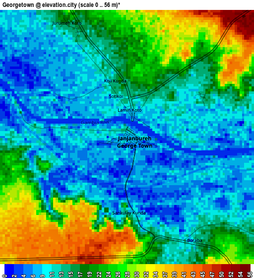
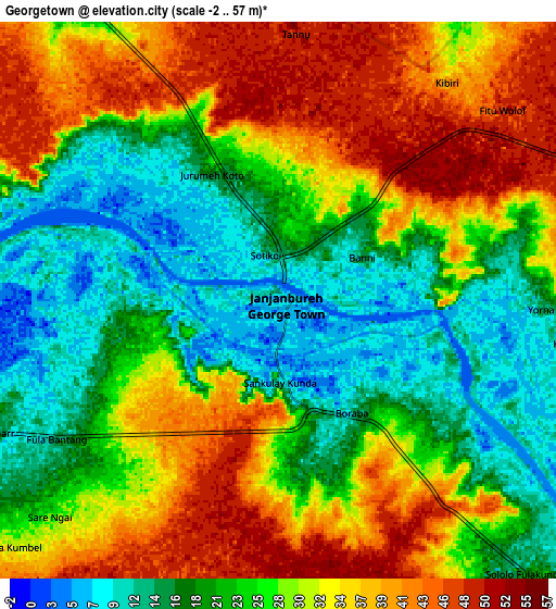
Below is the Elevation map of Georgetown, which displays elevation range with different colors. Scale of the first map is from 0 to 56 m (0 to 184 ft) with average elevation of 16.5 meters (=54 ft) [note 1]
These maps also provides idea of topography and contour of this city, they are displayed at different zoom levels. More info about maps, scale and edge coordinates you can find below images.
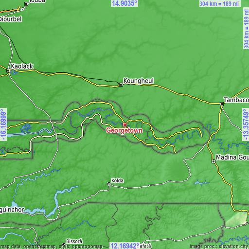
| \ | Map #1 | Map #2 | Topo.Map |
| Scale [m] | 0..56 m | -2..57 m | × |
| Scale [ft] | 0..184 ft | -7..187 ft | × |
| Average | 16.5 m = 54 ft | 27.2 m = 89 ft | × |
| Width | 9.5 km = 5.9 mi | 19 km = 11.8 mi | 304 km = 188.9 mi |
| Height | 9.5 km = 5.9 mi | 19 km = 11.8 mi | 304 km = 188.9 mi |
| ↑Max Latitude | 13.58311° | 13.625822° | 14.9035° |
| Latitude at center | 13.54039° | 13.54039° | 13.54039° |
| ↓Min Latitude | 13.497662° | 13.454927° | 12.16942° |
| ← Min Longitude | -14.807685° | -14.851631° | -16.16999° |
| Longitude center | -14.76374° | -14.76374° | -14.76374° |
| →Max Longitude | -14.719795° | -14.675849° | -13.35749° |
Nearby cities:
Cities around Georgetown sort by population:
• Bansang elevation 9 m
17.1 km,  134°
134°
• Kuntaur 5 m
19.9 km,  316°
316°
• Saruja 11 m
16.6 km,  273°
273°
• Galleh Manda 46 m
12.1 km,  190°
190°
• Jakhaly 11 m
22 km, 272°
• Karantaba 11 m
32.3 km,  295°
295°
• Denton 18 m
18.9 km,  256°
256°
• Wassu 11 m
20.9 km, 323°
• Sukuta 13 m
18.6 km, 297°
• Kunting 14 m
10.5 km,  94°
94°
• Kass Wollof 44 m
32.6 km,  325°
325°
• Brikama Nding 16 m
18.3 km, 267°
Multilingual:
 En español:
Georgetown elevación 7 m.
 En France:
Jan Jan Bureh élévation 7 m.
 Auf Deutsch:
Georgetown höhe über dem Meeresspiegel ist 7 m.

Sources and notes:
- [note 1] Map square and city borders are not equal. Map elevation data is calculated only from area inside that square.
- [src 1] Elevation data from geonames database provided with same terms of usage.
- [src 2] The elevation map of Georgetown is generated using elevation data from NASA's 3 arcsec (90m) resolution SRTM data.
- [src 3] Base (background) map © OpenStreetMap contributors tiles are generated by Geofabrik and OpenTopoMap.
Copyright & License:
This Georgetown Elevation Map is licensed under CC BY-SA. You may reuse any part from this page, if you give a proper credit by linking to this URL:
 More info on terms of use page.