Soma elevation
Soma (Lower River), Gambia elevation is 21 meters and Soma elevation in feet is 69 ft above sea level [src 1]. Soma is a populated place (feature code) with elevation that is 0 meters (0 ft) bigger than average city elevation in Gambia.
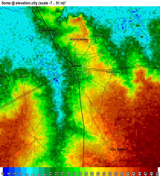
Below is the Elevation map of Soma, which displays elevation range with different colors. Scale of the first map is from -7 to 51 m (-23 to 167 ft) with average elevation of 22.6 meters (=74 ft) [note 1]
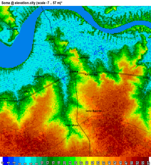
These maps also provides idea of topography and contour of this city, they are displayed at different zoom levels. More info about maps, scale and edge coordinates you can find below images.
| \ | Map #1 | Map #2 | Topo.Map |
| Scale [m] | -7..51 m | -7..57 m | × |
| Scale [ft] | -23..167 ft | -23..187 ft | × |
| Average | 22.6 m = 74 ft | 23.5 m = 77 ft | × |
| Width | 9.51 km = 5.9 mi | 19.01 km = 11.8 mi | 304.1 km = 189 mi |
| Height | 9.51 km = 5.9 mi | 19.01 km = 11.8 mi | 304.2 km = 189 mi |
| ↑Max Latitude | 13.476069° | 13.518801° | 14.79709° |
| Latitude at center | 13.43333° | 13.43333° | 13.43333° |
| ↓Min Latitude | 13.390583° | 13.347829° | 12.06178° |
| ← Min Longitude | -15.577275° | -15.621221° | -16.93958° |
| Longitude center | -15.53333° | -15.53333° | -15.53333° |
| →Max Longitude | -15.489385° | -15.445439° | -14.12708° |
Nearby cities:
Cities around Soma sort by population:
• Farafenni elevation 15 m
16.5 km,  334°
334°
• Mansa Konko 19 m
1.1 km,  346°
346°
• Sankwia 4 m
4.1 km,  25°
25°
• Kaiaf 29 m
9.7 km,  247°
247°
• Toniataba 4 m
5.4 km,  270°
270°
• Katchang 20 m
24.6 km,  287°
287°
• Wellingara Ba 28 m
14.5 km,  97°
97°
• Karantaba 37 m
1.8 km,  90°
90°
• Si Kunda 28 m
3.6 km, 270°
• Sara Kunda 20 m
16.8 km,  48°
48°
• Bambali 17 m
22.3 km,  75°
75°
• Jenoi 8 m
6.6 km, 327°
Multilingual:
 En español:
Soma elevación 21 m.
 En France:
Soma élévation 21 m.


Sources and notes:
- [note 1] Map square and city borders are not equal. Map elevation data is calculated only from area inside that square.
- [src 1] Elevation data from geonames database provided with same terms of usage.
- [src 2] The elevation map of Soma is generated using elevation data from NASA's 3 arcsec (90m) resolution SRTM data.
- [src 3] Base (background) map © OpenStreetMap contributors tiles are generated by Geofabrik and OpenTopoMap.
Copyright & License:
This Soma Elevation Map is licensed under CC BY-SA. You may reuse any part from this page, if you give a proper credit by linking to this URL:
 More info on terms of use page.