Tarkwa elevation
Tarkwa (Western), Ghana elevation is 66 meters and Tarkwa elevation in feet is 217 ft above sea level [src 1]. Tarkwa is a populated place (feature code) with elevation that is 104 meters (341 ft) smaller than average city elevation in Ghana.
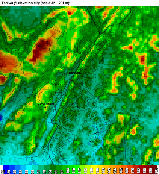
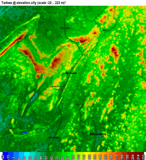
Below is the Elevation map of Tarkwa, which displays elevation range with different colors. Scale of the first map is from 32 to 201 m (105 to 659 ft) with average elevation of 95.1 meters (=312 ft) [note 1]
These maps also provides idea of topography and contour of this city, they are displayed at different zoom levels. More info about maps, scale and edge coordinates you can find below images.
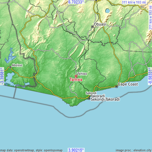
| \ | Map #1 | Map #2 | Topo.Map |
| Scale [m] | 32..201 m | -22..223 m | × |
| Scale [ft] | 105..659 ft | -72..732 ft | × |
| Average | 95.1 m = 312 ft | 85.1 m = 279 ft | × |
| Width | 9.73 km = 6 mi | 19.46 km = 12.1 mi | 311.4 km = 193.5 mi |
| Height | 9.73 km = 6 mi | 19.46 km = 12.1 mi | 311.4 km = 193.5 mi |
| ↑Max Latitude | 5.347586° | 5.391338° | 6.70233° |
| Latitude at center | 5.30383° | 5.30383° | 5.30383° |
| ↓Min Latitude | 5.260071° | 5.21631° | 3.90215° |
| ← Min Longitude | -2.033505° | -2.077451° | -3.39581° |
| Longitude center | -1.98956° | -1.98956° | -1.98956° |
| →Max Longitude | -1.945615° | -1.901669° | -0.58331° |
Nearby cities:
Cities around Tarkwa sort by population:
• Takoradi elevation 74 m
51.8 km,  150°
150°
• Cape Coast 21 m
85.2 km,  105°
105°
• Sekondi-Takoradi 73 m
49.2 km, 148°
• Prestea 69 m
22.3 km,  310°
310°
• Dunkwa 118 m
76.6 km,  17°
17°
• Elmina 21 m
74.8 km, 109°
• Saltpond 14 m
103.4 km,  95°
95°
• Axim 8 m
56.1 km,  209°
209°
• Shama Junction 12 m
48 km,  131°
131°
• Foso 148 m
89.5 km,  60°
60°
• Aboso 73 m
7.8 km,  35°
35°
• Wassa-Akropong 86 m
54.7 km,  349°
349°
Multilingual:
 En español:
Tarkwa elevación 66 m.
 En France:
Tarkwa élévation 66 m.


Sources and notes:
- [note 1] Map square and city borders are not equal. Map elevation data is calculated only from area inside that square.
- [src 1] Elevation data from geonames database provided with same terms of usage.
- [src 2] The elevation map of Tarkwa is generated using elevation data from NASA's 3 arcsec (90m) resolution SRTM data.
- [src 3] Base (background) map © OpenStreetMap contributors tiles are generated by Geofabrik and OpenTopoMap.
Copyright & License:
This Tarkwa Elevation Map is licensed under CC BY-SA. You may reuse any part from this page, if you give a proper credit by linking to this URL:
 More info on terms of use page.