Grand-Santi elevation
Grand-Santi (Guyane), French Guiana elevation is 52 meters and Grand-Santi elevation in feet is 171 ft above sea level [src 1]. Grand-Santi is a populated place (feature code) with elevation that is 27 meters (89 ft) bigger than average city elevation in French Guiana.
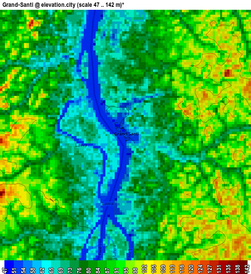
Below is the Elevation map of Grand-Santi, which displays elevation range with different colors. Scale of the first map is from 47 to 142 m (154 to 466 ft) with average elevation of 81.8 meters (=268 ft) [note 1]
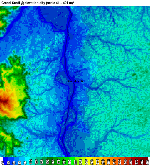
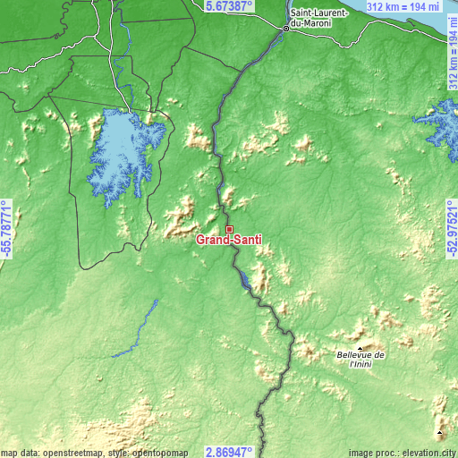
These maps also provides idea of topography and contour of this city, they are displayed at different zoom levels. More info about maps, scale and edge coordinates you can find below images.
| \ | Map #1 | Map #2 | Topo.Map |
| Scale [m] | 47..142 m | 41..401 m | × |
| Scale [ft] | 154..466 ft | 135..1316 ft | × |
| Average | 81.8 m = 268 ft | 99.2 m = 325 ft | × |
| Width | 9.75 km = 6.1 mi | 19.49 km = 12.1 mi | 311.8 km = 193.7 mi |
| Height | 9.75 km = 6.1 mi | 19.49 km = 12.1 mi | 311.9 km = 193.8 mi |
| ↑Max Latitude | 4.316772° | 4.360591° | 5.67387° |
| Latitude at center | 4.27295° | 4.27295° | 4.27295° |
| ↓Min Latitude | 4.229126° | 4.185299° | 2.86947° |
| ← Min Longitude | -54.425405° | -54.469351° | -55.78771° |
| Longitude center | -54.38146° | -54.38146° | -54.38146° |
| →Max Longitude | -54.337515° | -54.293569° | -52.97521° |
Nearby cities:
Cities around Grand-Santi sort by population:
• Cayenne elevation 7 m
238.6 km,  72°
72°
• Matoury 28 m
236.9 km, 74°
• Saint-Laurent-du-Maroni 9 m
142.1 km,  15°
15°
• Kourou 7 m
216.6 km,  62°
62°
• Macouria 14 m
233.5 km, 72°
• Mana 1 m
169 km, 23°
• Apatou 15 m
98.2 km,  2°
2°
• Sinnamary 6 m
199.9 km,  52°
52°
• Roura 14 m
233.5 km,  77°
77°
• Iracoubo 6 m
187 km,  44°
44°
• Rémire 77 m
242.8 km, 73°
• Maripasoula 106 m
80.2 km,  151°
151°
Multilingual:
 En español:
Grand-Santi elevación 52 m.
 En France:
Grand-Santi élévation 52 m.
 Auf Deutsch:
Grand-Santi höhe über dem Meeresspiegel ist 52 m.

Sources and notes:
- [note 1] Map square and city borders are not equal. Map elevation data is calculated only from area inside that square.
- [src 1] Elevation data from geonames database provided with same terms of usage.
- [src 2] The elevation map of Grand-Santi is generated using elevation data from NASA's 3 arcsec (90m) resolution SRTM data.
- [src 3] Base (background) map © OpenStreetMap contributors tiles are generated by Geofabrik and OpenTopoMap.
Copyright & License:
This Grand-Santi Elevation Map is licensed under CC BY-SA. You may reuse any part from this page, if you give a proper credit by linking to this URL:
 More info on terms of use page.