Aspindza elevation
Aspindza (Samtskhe-Javakheti), Georgia elevation is 1084 meters and Aspindza elevation in feet is 3556 ft above sea level [src 1]. Aspindza is a populated place (feature code) with elevation that is 544 meters (1785 ft) bigger than average city elevation in Georgia.
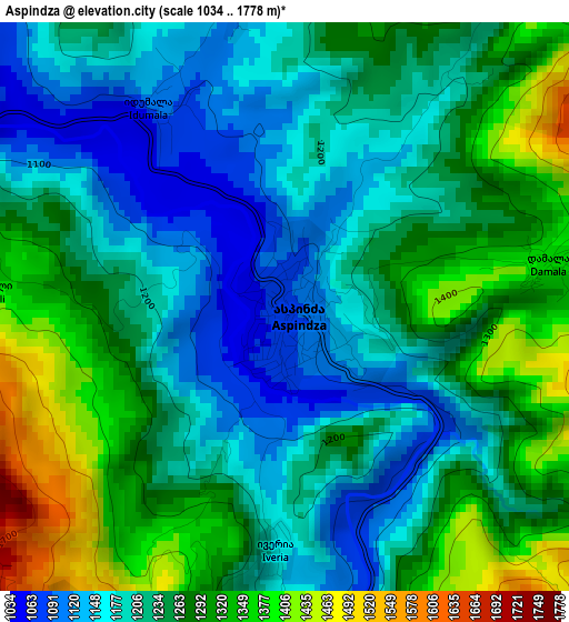
Below is the Elevation map of Aspindza, which displays elevation range with different colors. Scale of the first map is from 1034 to 1778 m (3392 to 5833 ft) with average elevation of 1241.4 meters (=4073 ft) [note 1]
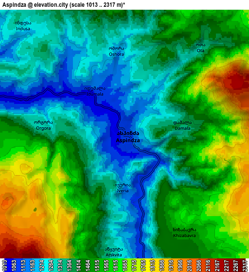
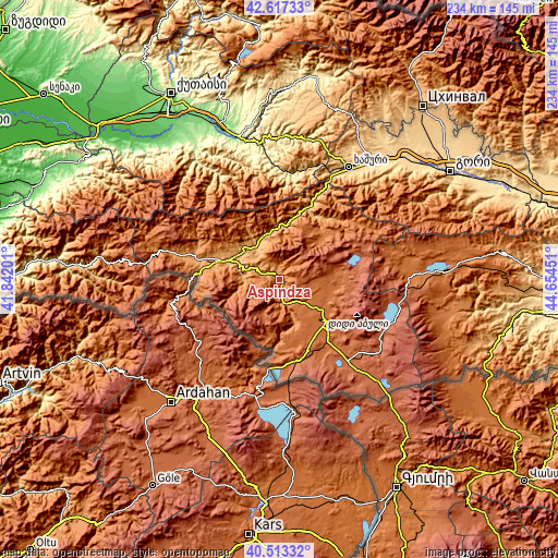
These maps also provides idea of topography and contour of this city, they are displayed at different zoom levels. More info about maps, scale and edge coordinates you can find below images.
| \ | Map #1 | Map #2 | Topo.Map |
| Scale [m] | 1034..1778 m | 1013..2317 m | × |
| Scale [ft] | 3392..5833 ft | 3323..7602 ft | × |
| Average | 1241.4 m = 4073 ft | 1448.7 m = 4753 ft | × |
| Width | 7.31 km = 4.5 mi | 14.62 km = 9.1 mi | 233.9 km = 145.3 mi |
| Height | 7.31 km = 4.5 mi | 14.62 km = 9.1 mi | 233.9 km = 145.3 mi |
| ↑Max Latitude | 41.606757° | 41.639608° | 42.61733° |
| Latitude at center | 41.57389° | 41.57389° | 41.57389° |
| ↓Min Latitude | 41.541006° | 41.508106° | 40.51332° |
| ← Min Longitude | 43.204315° | 43.160369° | 41.84201° |
| Longitude center | 43.24826° | 43.24826° | 43.24826° |
| →Max Longitude | 43.292205° | 43.336151° | 44.65451° |
Nearby cities:
Cities around Aspindza sort by population:
• Akhaltsikhe elevation 984 m
23.2 km,  288°
288°
• Borjomi 810 m
33.9 km,  23°
23°
• Akhalk’alak’i 1717 m
27.3 km,  133°
133°
• Ninotsminda 1944 m
44.7 km,  140°
140°
• Vale 1172 m
31.6 km,  278°
278°
• Tsaghveri 1082 m
32.1 km,  37°
37°
• Akhaldaba 742 m
44.2 km,  26°
26°
• Bakuriani 1674 m
30.7 km,  50°
50°
• Adigeni 1253 m
47.2 km, 284°
• Abastumani 1203 m
36.6 km, 293°
• Bakurianis Andeziti 1568 m
25.7 km, 46°
• Kharagauli 310 m
49.9 km,  355°
355°
Multilingual:
 En español:
Aspindza elevación 1084 m.
 En France:
Aspindza élévation 1084 m.
 Auf Deutsch:
Aspindza höhe über dem Meeresspiegel ist 1084 m.

Sources and notes:
- [note 1] Map square and city borders are not equal. Map elevation data is calculated only from area inside that square.
- [src 1] Elevation data from geonames database provided with same terms of usage.
- [src 2] The elevation map of Aspindza is generated using elevation data from NASA's 3 arcsec (90m) resolution SRTM data.
- [src 3] Base (background) map © OpenStreetMap contributors tiles are generated by Geofabrik and OpenTopoMap.
Copyright & License:
This Aspindza Elevation Map is licensed under CC BY-SA. You may reuse any part from this page, if you give a proper credit by linking to this URL:
 More info on terms of use page.