Gudauri elevation
Gudauri (Mtskheta-Mtianeti), Georgia elevation is 2223 meters and Gudauri elevation in feet is 7293 ft above sea level [src 1]. Gudauri is a populated place (feature code) with elevation that is 1683 meters (5522 ft) bigger than average city elevation in Georgia.
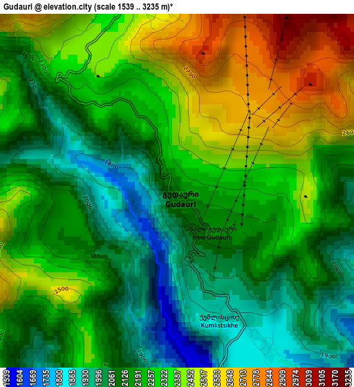
Below is the Elevation map of Gudauri, which displays elevation range with different colors. Scale of the first map is from 1539 to 3235 m (5049 to 10614 ft) with average elevation of 2244.8 meters (=7365 ft) [note 1]
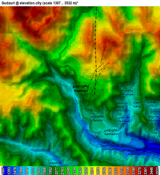
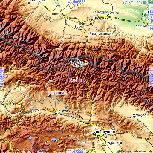
These maps also provides idea of topography and contour of this city, they are displayed at different zoom levels. More info about maps, scale and edge coordinates you can find below images.
| \ | Map #1 | Map #2 | Topo.Map |
| Scale [m] | 1539..3235 m | 1307..3532 m | × |
| Scale [ft] | 5049..10614 ft | 4288..11588 ft | × |
| Average | 2244.8 m = 7365 ft | 2305.5 m = 7564 ft | × |
| Width | 7.21 km = 4.5 mi | 14.42 km = 9 mi | 230.6 km = 143.3 mi |
| Height | 7.21 km = 4.5 mi | 14.42 km = 9 mi | 230.6 km = 143.3 mi |
| ↑Max Latitude | 42.510373° | 42.542759° | 43.50653° |
| Latitude at center | 42.47797° | 42.47797° | 42.47797° |
| ↓Min Latitude | 42.44555° | 42.413114° | 41.43222° |
| ← Min Longitude | 44.432215° | 44.388269° | 43.06991° |
| Longitude center | 44.47616° | 44.47616° | 44.47616° |
| →Max Longitude | 44.520105° | 44.564051° | 45.88241° |
Nearby cities:
Cities around Gudauri sort by population:
• Gori elevation 600 m
62.4 km,  208°
208°
• Ts’khinvali 874 m
50.1 km,  236°
236°
• Kaspi 549 m
61.6 km,  183°
183°
• Mtskheta 476 m
73.1 km,  164°
164°
• Agara 642 m
72.7 km,  227°
227°
• Zhinvali 754 m
45.6 km,  147°
147°
• Dzegvi 503 m
71.1 km,  171°
171°
• P’asanauri 1070 m
22.5 km,  129°
129°
• Step’antsminda 1767 m
24.1 km,  34°
34°
• Akhalgori 822 m
39.1 km, 179°
• Java 1084 m
45.1 km,  258°
258°
• T’ianet’i 1107 m
57.4 km,  135°
135°
Multilingual:
 En español:
Gudauri elevación 2223 m.
 En France:
Gudauri élévation 2223 m.
 Auf Deutsch:
Gudauri höhe über dem Meeresspiegel ist 2223 m.

Sources and notes:
- [note 1] Map square and city borders are not equal. Map elevation data is calculated only from area inside that square.
- [src 1] Elevation data from geonames database provided with same terms of usage.
- [src 2] The elevation map of Gudauri is generated using elevation data from NASA's 3 arcsec (90m) resolution SRTM data.
- [src 3] Base (background) map © OpenStreetMap contributors tiles are generated by Geofabrik and OpenTopoMap.
Copyright & License:
This Gudauri Elevation Map is licensed under CC BY-SA. You may reuse any part from this page, if you give a proper credit by linking to this URL:
 More info on terms of use page.