Sokhumi elevation
Sokhumi (Abkhazia), Georgia elevation is 21 meters and Sokhumi elevation in feet is 69 ft above sea level [src 1]. Sokhumi is a seat of a first-order administrative division (feature code) with elevation that is 519 meters (1703 ft) smaller than average city elevation in Georgia.
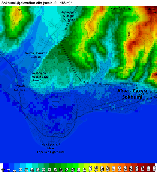
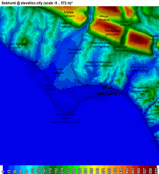
Below is the Elevation map of Sokhumi, which displays elevation range with different colors. Scale of the first map is from -9 to 188 m (-30 to 617 ft) with average elevation of 29 meters (=95 ft) [note 1]
These maps also provides idea of topography and contour of this city, they are displayed at different zoom levels. More info about maps, scale and edge coordinates you can find below images.
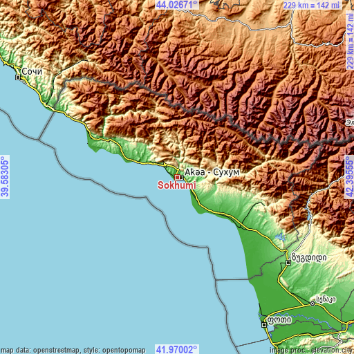
| \ | Map #1 | Map #2 | Topo.Map |
| Scale [m] | -9..188 m | -9..572 m | × |
| Scale [ft] | -30..617 ft | -30..1877 ft | × |
| Average | 29 m = 95 ft | 66.9 m = 219 ft | × |
| Width | 7.15 km = 4.4 mi | 14.29 km = 8.9 mi | 228.7 km = 142.1 mi |
| Height | 7.15 km = 4.4 mi | 14.29 km = 8.9 mi | 228.7 km = 142.1 mi |
| ↑Max Latitude | 43.039098° | 43.071208° | 44.02671° |
| Latitude at center | 43.00697° | 43.00697° | 43.00697° |
| ↓Min Latitude | 42.974826° | 42.942665° | 41.97002° |
| ← Min Longitude | 40.945355° | 40.901409° | 39.58305° |
| Longitude center | 40.9893° | 40.9893° | 40.9893° |
| →Max Longitude | 41.033245° | 41.077191° | 42.39555° |
Nearby cities:
Cities around Sokhumi sort by population:
• Stantsiya Novyy Afon elevation 8 m
14.7 km,  303°
303°
• Tqvarch'eli 227 m
59.2 km,  108°
108°
• Och’amch’ire 5 m
51 km,  129°
129°
• Gali 61 m
74.3 km,  124°
124°
• Bich’vinta 1 m
55.4 km,  288°
288°
• Gagra 11 m
65.6 km, 297°
• Gudauta 9 m
31.9 km, 290°
• Dranda 25 m
20.1 km,  138°
138°
• P’rimorsk’oe 18 m
25.6 km, 291°
• Kelasuri 91 m
7.3 km, 115°
• Orsant’ia 17 m
82 km, 137°
• Gulrip’shi 7 m
12.5 km, 135°
Multilingual:
 En español:
Sujumi elevación 21 m.
 En France:
Soukhoumi élévation 21 m.


Sources and notes:
- [note 1] Map square and city borders are not equal. Map elevation data is calculated only from area inside that square.
- [src 1] Elevation data from geonames database provided with same terms of usage.
- [src 2] The elevation map of Sokhumi is generated using elevation data from NASA's 3 arcsec (90m) resolution SRTM data.
- [src 3] Base (background) map © OpenStreetMap contributors tiles are generated by Geofabrik and OpenTopoMap.
Copyright & License:
This Sokhumi Elevation Map is licensed under CC BY-SA. You may reuse any part from this page, if you give a proper credit by linking to this URL:
 More info on terms of use page.