Telavi elevation
Telavi (Kakheti), Georgia elevation is 722 meters and Telavi elevation in feet is 2369 ft above sea level [src 1]. Telavi is a seat of a first-order administrative division (feature code) with elevation that is 182 meters (597 ft) bigger than average city elevation in Georgia.
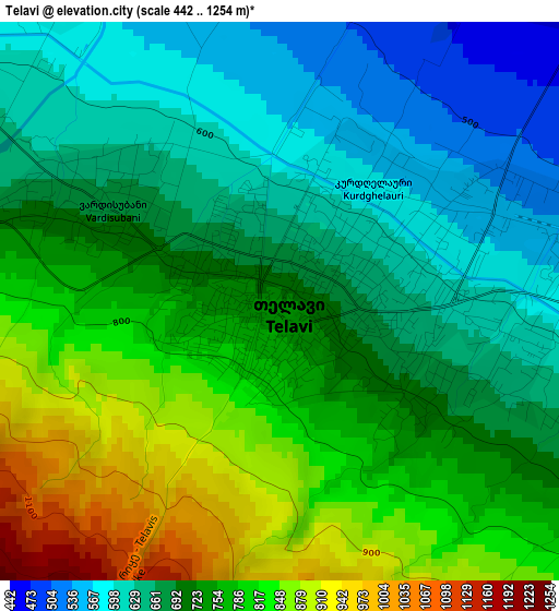
Below is the Elevation map of Telavi, which displays elevation range with different colors. Scale of the first map is from 442 to 1254 m (1450 to 4114 ft) with average elevation of 725.4 meters (=2380 ft) [note 1]
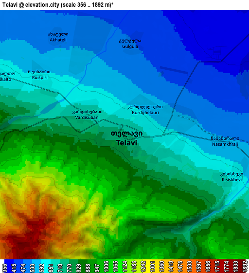
These maps also provides idea of topography and contour of this city, they are displayed at different zoom levels. More info about maps, scale and edge coordinates you can find below images.
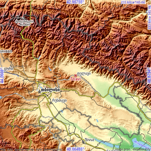
| \ | Map #1 | Map #2 | Topo.Map |
| Scale [m] | 442..1254 m | 356..1892 m | × |
| Scale [ft] | 1450..4114 ft | 1168..6207 ft | × |
| Average | 725.4 m = 2380 ft | 769.1 m = 2523 ft | × |
| Width | 7.27 km = 4.5 mi | 14.54 km = 9 mi | 232.7 km = 144.6 mi |
| Height | 7.27 km = 4.5 mi | 14.54 km = 9 mi | 232.7 km = 144.6 mi |
| ↑Max Latitude | 41.95247° | 41.985144° | 42.95755° |
| Latitude at center | 41.91978° | 41.91978° | 41.91978° |
| ↓Min Latitude | 41.887073° | 41.854349° | 40.86485° |
| ← Min Longitude | 45.429205° | 45.385259° | 44.0669° |
| Longitude center | 45.47315° | 45.47315° | 45.47315° |
| →Max Longitude | 45.517095° | 45.561041° | 46.8794° |
Nearby cities:
Cities around Telavi sort by population:
• Tbilisi elevation 491 m
58.6 km,  244°
244°
• Rust’avi 338 m
57.3 km,  224°
224°
• Sagarejo 748 m
23.8 km,  209°
209°
• Gurjaani 400 m
33.5 km,  125°
125°
• Qvareli 442 m
28.7 km,  82°
82°
• Akhmet’a 582 m
25.2 km,  299°
299°
• Tsnori 296 m
52.9 km, 128°
• Bagdadi 251 m
47.8 km,  103°
103°
• Tsinandali 605 m
8.6 km,  110°
110°
• Didi Lilo 789 m
46.8 km, 244°
• Sighnaghi 779 m
49.9 km, 131°
• T’ianet’i 1107 m
47 km, 296°
Multilingual:
 En español:
Telavi elevación 722 m.
 En France:
Telavi élévation 722 m.


Sources and notes:
- [note 1] Map square and city borders are not equal. Map elevation data is calculated only from area inside that square.
- [src 1] Elevation data from geonames database provided with same terms of usage.
- [src 2] The elevation map of Telavi is generated using elevation data from NASA's 3 arcsec (90m) resolution SRTM data.
- [src 3] Base (background) map © OpenStreetMap contributors tiles are generated by Geofabrik and OpenTopoMap.
Copyright & License:
This Telavi Elevation Map is licensed under CC BY-SA. You may reuse any part from this page, if you give a proper credit by linking to this URL:
 More info on terms of use page.