Kaustinen elevation
Kaustinen (Central Ostrobothnia), Finland elevation is 66 meters and Kaustinen elevation in feet is 217 ft above sea level [src 1]. Kaustinen is a seat of a third-order administrative division (feature code) with elevation that is 11 meters (36 ft) smaller than average city elevation in Finland.
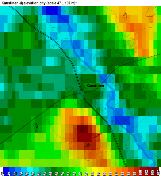
Below is the Elevation map of Kaustinen, which displays elevation range with different colors. Scale of the first map is from 47 to 107 m (154 to 351 ft) with average elevation of 69.5 meters (=228 ft) [note 1]
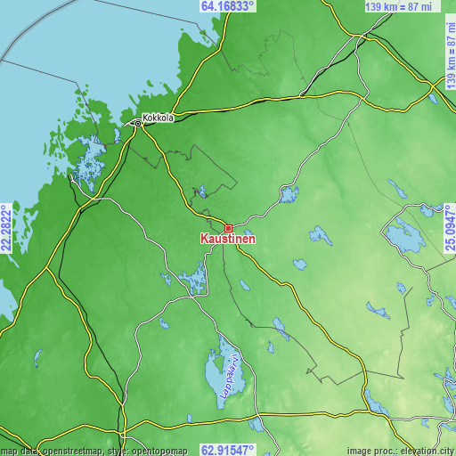
These maps also provides idea of topography and contour of this city, they are displayed at different zoom levels. More info about maps, scale and edge coordinates you can find below images.
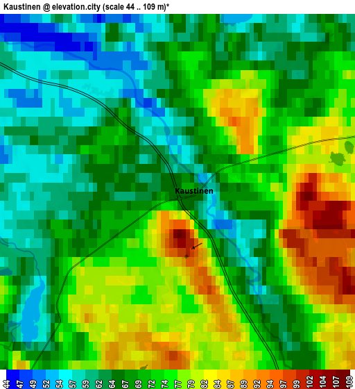
| \ | Map #1 | Map #2 | Topo.Map |
| Scale [m] | 47..107 m | 44..109 m | × |
| Scale [ft] | 154..351 ft | 144..358 ft | × |
| Average | 69.5 m = 228 ft | 70.1 m = 230 ft | × |
| Width | 4.35 km = 2.7 mi | 8.71 km = 5.4 mi | 139.3 km = 86.6 mi |
| Height | 4.35 km = 2.7 mi | 8.71 km = 5.4 mi | 139.3 km = 86.6 mi |
| ↑Max Latitude | 63.568348° | 63.587903° | 64.16833° |
| Latitude at center | 63.54878° | 63.54878° | 63.54878° |
| ↓Min Latitude | 63.529198° | 63.509603° | 62.91547° |
| ← Min Longitude | 23.644505° | 23.600559° | 22.2822° |
| Longitude center | 23.68845° | 23.68845° | 23.68845° |
| →Max Longitude | 23.732395° | 23.776341° | 25.0947° |
Nearby cities:
Cities around Kaustinen sort by population:
• Kokkola elevation 9 m
42.3 km,  319°
319°
• Kronoby 12 m
38 km,  301°
301°
• Kannus 62 m
40.4 km,  14°
14°
• Kälviä 27 m
36.6 km,  341°
341°
• Lappajärvi 74 m
38.9 km,  184°
184°
• Veteli 89 m
9.1 km,  149°
149°
• Toholampi 94 m
36.8 km,  48°
48°
• Vimpeli 72 m
43.5 km,  171°
171°
• Evijärvi 67 m
22.7 km,  206°
206°
• Kortesjärvi 57 m
37.9 km,  223°
223°
• Halsua 131 m
25.4 km,  111°
111°
• Ullava 124 m
20.4 km,  73°
73°
Multilingual:
 En español:
Kaustinen elevación 66 m.
 En France:
Kaustinen élévation 66 m.
 Auf Deutsch:
Kaustinen höhe über dem Meeresspiegel ist 66 m.

Sources and notes:
- [note 1] Map square and city borders are not equal. Map elevation data is calculated only from area inside that square.
- [src 1] Elevation data from geonames database provided with same terms of usage.
- [src 2] The elevation map of Kaustinen is generated using GMTED2010 database with 7.5 arcsec (225m) resolution.
- [src 3] Base (background) map © OpenStreetMap contributors tiles are generated by Geofabrik and OpenTopoMap.
Copyright & License:
This Kaustinen Elevation Map is licensed under CC BY-SA. You may reuse any part from this page, if you give a proper credit by linking to this URL:
 More info on terms of use page.