Kinnula elevation
Kinnula (Central Finland, Saarijärvi-Viitasaari), Finland elevation is 156 meters and Kinnula elevation in feet is 512 ft above sea level [src 1]. Kinnula is a seat of a third-order administrative division (feature code) with elevation that is 79 meters (259 ft) bigger than average city elevation in Finland.
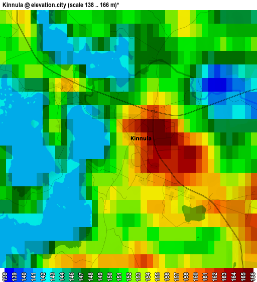
Below is the Elevation map of Kinnula, which displays elevation range with different colors. Scale of the first map is from 138 to 166 m (453 to 545 ft) with average elevation of 149.9 meters (=492 ft) [note 1]
These maps also provides idea of topography and contour of this city, they are displayed at different zoom levels. More info about maps, scale and edge coordinates you can find below images.
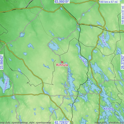
| \ | Map #1 | Topo.Map |
| Scale [m] | 138..166 m | × |
| Scale [ft] | 453..545 ft | × |
| Average | 149.9 m = 492 ft | × |
| Width | 4.38 km = 2.7 mi | 140.2 km = 87.1 mi |
| Height | 4.38 km = 2.7 mi | 140.2 km = 87.1 mi |
| ↑Max Latitude | 63.386363° | 63.99019° |
| Latitude at center | 63.36667° | 63.36667° |
| ↓Min Latitude | 63.346963° | 62.72932° |
| ← Min Longitude | 24.922725° | 23.56042° |
| Longitude center | 24.96667° | 24.96667° |
| →Max Longitude | 25.010615° | 26.37292° |
Nearby cities:
Cities around Kinnula sort by population:
• Haapajärvi elevation 102 m
46.3 km,  23°
23°
• Viitasaari 142 m
56.1 km,  126°
126°
• Pihtipudas 131 m
30 km,  86°
86°
• Reisjärvi 119 m
28 km,  353°
353°
• Perho 174 m
32.2 km,  238°
238°
• Kinnula 143 m
2 km,  335°
335°
• Kyyjärvi 186 m
42.1 km,  208°
208°
• Kannonkoski 122 m
46.7 km,  162°
162°
• Kivijärvi 149 m
28 km,  168°
168°
• Halsua 131 m
41.3 km,  285°
285°
• Ullava 124 m
50.9 km,  300°
300°
• Lestijärvi 155 m
24.3 km,  319°
319°
Multilingual:
 En español:
Kinnula elevación 156 m.
 En France:
Kinnula élévation 156 m.


Sources and notes:
- [note 1] Map square and city borders are not equal. Map elevation data is calculated only from area inside that square.
- [src 1] Elevation data from geonames database provided with same terms of usage.
- [src 2] The elevation map of Kinnula is generated using GMTED2010 database with 7.5 arcsec (225m) resolution.
- [src 3] Base (background) map © OpenStreetMap contributors tiles are generated by Geofabrik and OpenTopoMap.
Copyright & License:
This Kinnula Elevation Map is licensed under CC BY-SA. You may reuse any part from this page, if you give a proper credit by linking to this URL:
 More info on terms of use page.