Pargas elevation
Pargas (Southwest Finland, Åboland-Turunmaa), Finland elevation is 23 meters and Pargas elevation in feet is 75 ft above sea level [src 1]. Pargas is a seat of a third-order administrative division (feature code) with elevation that is 54 meters (177 ft) smaller than average city elevation in Finland.
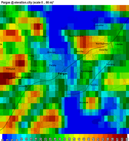
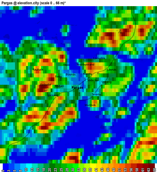
Below is the Elevation map of Pargas, which displays elevation range with different colors. Scale of the first map is from 0 to 66 m (0 to 217 ft) with average elevation of 22.2 meters (=73 ft) [note 1]
These maps also provides idea of topography and contour of this city, they are displayed at different zoom levels. More info about maps, scale and edge coordinates you can find below images.
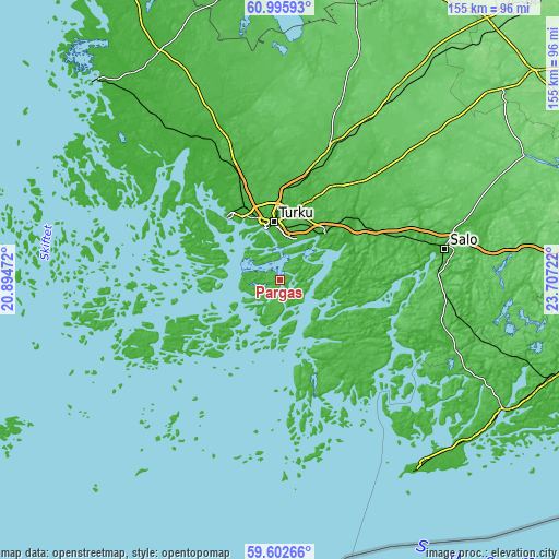
| \ | Map #1 | Map #2 | Topo.Map |
| Scale [m] | 0..66 m | 0..66 m | × |
| Scale [ft] | 0..217 ft | 0..217 ft | × |
| Average | 22.2 m = 73 ft | 17.8 m = 58 ft | × |
| Width | 4.84 km = 3 mi | 9.68 km = 6 mi | 154.9 km = 96.3 mi |
| Height | 4.84 km = 3 mi | 9.68 km = 6 mi | 154.9 km = 96.3 mi |
| ↑Max Latitude | 60.328481° | 60.350228° | 60.99593° |
| Latitude at center | 60.30672° | 60.30672° | 60.30672° |
| ↓Min Latitude | 60.284944° | 60.263154° | 59.60266° |
| ← Min Longitude | 22.257025° | 22.213079° | 20.89472° |
| Longitude center | 22.30097° | 22.30097° | 22.30097° |
| →Max Longitude | 22.344915° | 22.388861° | 23.70722° |
Nearby cities:
Cities around Pargas sort by population:
• Turku elevation 22 m
16.2 km,  353°
353°
• Raisio 11 m
21.2 km,  340°
340°
• Kaarina 31 m
11.8 km,  18°
18°
• Väståboland 10 m
0.8 km,  182°
182°
• Lieto 15 m
24.3 km, 21°
• Naantali 9 m
23.5 km,  319°
319°
• Paimio 43 m
27 km,  51°
51°
• Piikkiö 11 m
17.7 km,  42°
42°
• Rusko 28 m
25.6 km, 349°
• Sauvo 12 m
22.1 km,  79°
79°
• Rymättylä 15 m
21.2 km,  291°
291°
• Nagu 2 m
25 km,  239°
239°
Multilingual:
 En español:
Pargas elevación 23 m.
 En France:
Pargas élévation 23 m.


Sources and notes:
- [note 1] Map square and city borders are not equal. Map elevation data is calculated only from area inside that square.
- [src 1] Elevation data from geonames database provided with same terms of usage.
- [src 2] The elevation map of Pargas is generated using GMTED2010 database with 7.5 arcsec (225m) resolution.
- [src 3] Base (background) map © OpenStreetMap contributors tiles are generated by Geofabrik and OpenTopoMap.
Copyright & License:
This Pargas Elevation Map is licensed under CC BY-SA. You may reuse any part from this page, if you give a proper credit by linking to this URL:
 More info on terms of use page.