Parikkala elevation
Parikkala (South Karelia, Imatra), Finland elevation is 100 meters and Parikkala elevation in feet is 328 ft above sea level [src 1]. Parikkala is a seat of a third-order administrative division (feature code) with elevation that is 23 meters (75 ft) bigger than average city elevation in Finland.
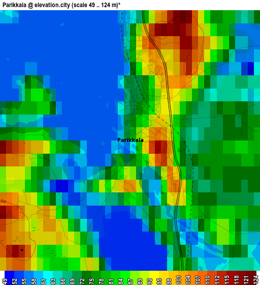
Below is the Elevation map of Parikkala, which displays elevation range with different colors. Scale of the first map is from 49 to 124 m (161 to 407 ft) with average elevation of 73.7 meters (=242 ft) [note 1]
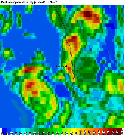
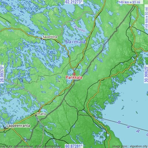
These maps also provides idea of topography and contour of this city, they are displayed at different zoom levels. More info about maps, scale and edge coordinates you can find below images.
| \ | Map #1 | Map #2 | Topo.Map |
| Scale [m] | 49..124 m | 46..130 m | × |
| Scale [ft] | 161..407 ft | 151..427 ft | × |
| Average | 73.7 m = 242 ft | 69.3 m = 227 ft | × |
| Width | 4.66 km = 2.9 mi | 9.31 km = 5.8 mi | 149 km = 92.6 mi |
| Height | 4.66 km = 2.9 mi | 9.31 km = 5.8 mi | 149 km = 92.6 mi |
| ↑Max Latitude | 61.570928° | 61.591842° | 62.21273° |
| Latitude at center | 61.55° | 61.55° | 61.55° |
| ↓Min Latitude | 61.529058° | 61.508101° | 60.87281° |
| ← Min Longitude | 29.456055° | 29.412109° | 28.09375° |
| Longitude center | 29.5° | 29.5° | 29.5° |
| →Max Longitude | 29.543945° | 29.587891° | 30.90625° |
Nearby cities:
Cities around Parikkala sort by population:
• Imatra elevation 68 m
57.9 km,  223°
223°
• Savonlinna 75 m
48.3 km,  317°
317°
• Kitee 66 m
70 km,  29°
29°
• Kerimäki 86 m
41.7 km,  344°
344°
• Ruokolahti 68 m
46.2 km,  230°
230°
• Rautjärvi 96 m
15.2 km,  211°
211°
• Punkaharju 64 m
24 km,  345°
345°
• Sulkava 98 m
65 km,  293°
293°
• Kesälahti 84 m
42.5 km,  24°
24°
• Enonkoski 103 m
66.3 km,  333°
333°
• Saari 76 m
17.3 km,  49°
49°
• Simpele 81 m
14.8 km, 208°
Multilingual:
 En español:
Parikkala elevación 100 m.
 En France:
Parikkala élévation 100 m.
 Auf Deutsch:
Parikkala höhe über dem Meeresspiegel ist 100 m.

Sources and notes:
- [note 1] Map square and city borders are not equal. Map elevation data is calculated only from area inside that square.
- [src 1] Elevation data from geonames database provided with same terms of usage.
- [src 2] The elevation map of Parikkala is generated using GMTED2010 database with 7.5 arcsec (225m) resolution.
- [src 3] Base (background) map © OpenStreetMap contributors tiles are generated by Geofabrik and OpenTopoMap.
Copyright & License:
This Parikkala Elevation Map is licensed under CC BY-SA. You may reuse any part from this page, if you give a proper credit by linking to this URL:
 More info on terms of use page.