Tampere elevation
Tampere (Pirkanmaa), Finland elevation is 114 meters and Tampere elevation in feet is 374 ft above sea level [src 1]. Tampere is a seat of a first-order administrative division (feature code) with elevation that is 37 meters (121 ft) bigger than average city elevation in Finland.
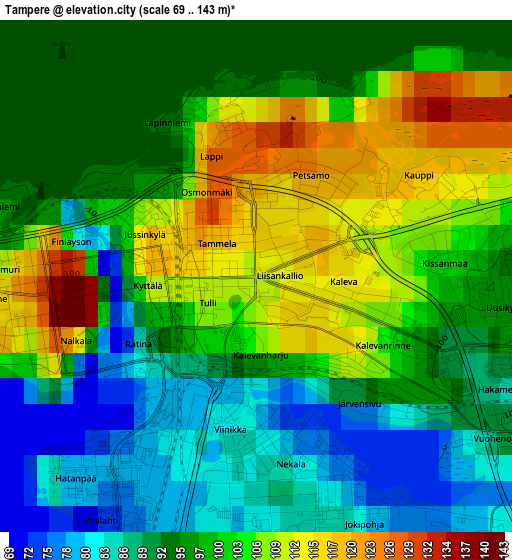
Below is the Elevation map of Tampere, which displays elevation range with different colors. Scale of the first map is from 69 to 143 m (226 to 469 ft) with average elevation of 97.2 meters (=319 ft) [note 1]
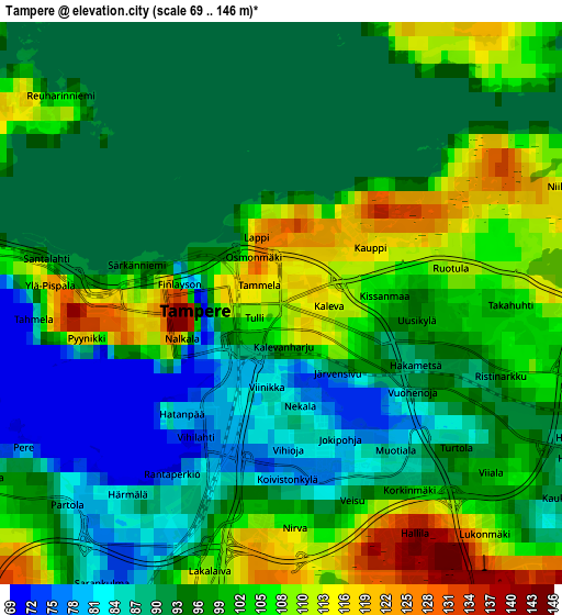
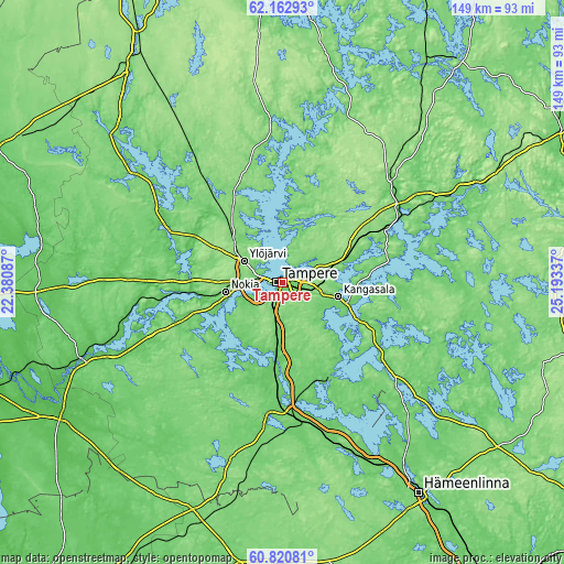
These maps also provides idea of topography and contour of this city, they are displayed at different zoom levels. More info about maps, scale and edge coordinates you can find below images.
| \ | Map #1 | Map #2 | Topo.Map |
| Scale [m] | 69..143 m | 69..146 m | × |
| Scale [ft] | 226..469 ft | 226..479 ft | × |
| Average | 97.2 m = 319 ft | 97.2 m = 319 ft | × |
| Width | 4.66 km = 2.9 mi | 9.33 km = 5.8 mi | 149.2 km = 92.7 mi |
| Height | 4.66 km = 2.9 mi | 9.33 km = 5.8 mi | 149.2 km = 92.7 mi |
| ↑Max Latitude | 61.520072° | 61.541021° | 62.16293° |
| Latitude at center | 61.49911° | 61.49911° | 61.49911° |
| ↓Min Latitude | 61.478133° | 61.457143° | 60.82081° |
| ← Min Longitude | 23.743175° | 23.699229° | 22.38087° |
| Longitude center | 23.78712° | 23.78712° | 23.78712° |
| →Max Longitude | 23.831065° | 23.875011° | 25.19337° |
Nearby cities:
Cities around Tampere sort by population:
• Nokia elevation 89 m
15.7 km,  256°
256°
• Kangasala 100 m
15.8 km,  104°
104°
• Ylöjärvi 107 m
12 km,  302°
302°
• Valkeakoski 98 m
29.2 km,  153°
153°
• Lempäälä 85 m
20.4 km,  185°
185°
• Pirkkala 101 m
9.2 km,  242°
242°
• Hämeenkyrö 65 m
35 km, 296°
• Viiala 78 m
32.1 km,  181°
181°
• Pälkäne 93 m
31.6 km,  125°
125°
• Vesilahti 93 m
22.2 km,  204°
204°
• Sahalahti 101 m
28.8 km, 95°
• Viljakkala 96 m
35.9 km,  309°
309°
Multilingual:
 En español:
Tampere elevación 114 m.
 En France:
Tampere élévation 114 m.


Sources and notes:
- [note 1] Map square and city borders are not equal. Map elevation data is calculated only from area inside that square.
- [src 1] Elevation data from geonames database provided with same terms of usage.
- [src 2] The elevation map of Tampere is generated using GMTED2010 database with 7.5 arcsec (225m) resolution.
- [src 3] Base (background) map © OpenStreetMap contributors tiles are generated by Geofabrik and OpenTopoMap.
Copyright & License:
This Tampere Elevation Map is licensed under CC BY-SA. You may reuse any part from this page, if you give a proper credit by linking to this URL:
 More info on terms of use page.