Tohmajärvi elevation
Tohmajärvi (North Karelia, Keski-Karjala), Finland elevation is 72 meters and Tohmajärvi elevation in feet is 236 ft above sea level [src 1]. Tohmajärvi is a seat of a third-order administrative division (feature code) with elevation that is 5 meters (16 ft) smaller than average city elevation in Finland.
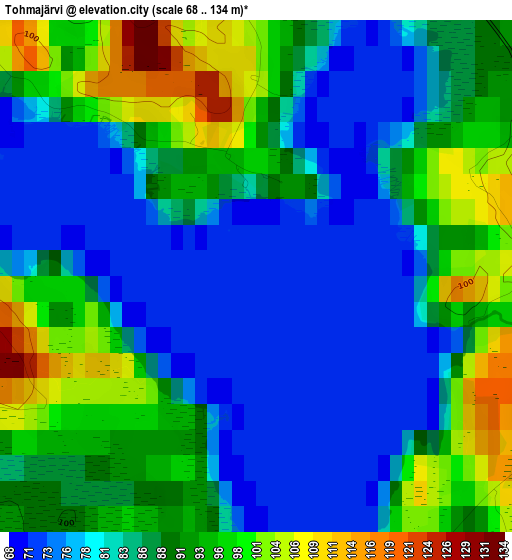
Below is the Elevation map of Tohmajärvi, which displays elevation range with different colors. Scale of the first map is from 68 to 134 m (223 to 440 ft) with average elevation of 86.7 meters (=284 ft) [note 1]
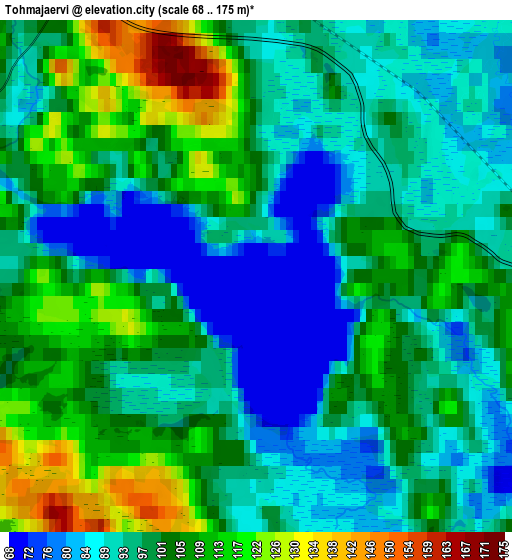
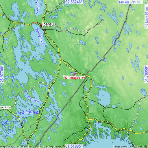
These maps also provides idea of topography and contour of this city, they are displayed at different zoom levels. More info about maps, scale and edge coordinates you can find below images.
| \ | Map #1 | Map #2 | Topo.Map |
| Scale [m] | 68..134 m | 68..175 m | × |
| Scale [ft] | 223..440 ft | 223..574 ft | × |
| Average | 86.7 m = 284 ft | 99.1 m = 325 ft | × |
| Width | 4.56 km = 2.8 mi | 9.12 km = 5.7 mi | 145.9 km = 90.7 mi |
| Height | 4.56 km = 2.8 mi | 9.12 km = 5.7 mi | 145.9 km = 90.7 mi |
| ↑Max Latitude | 62.20383° | 62.224316° | 62.83246° |
| Latitude at center | 62.18333° | 62.18333° | 62.18333° |
| ↓Min Latitude | 62.162816° | 62.142289° | 61.51995° |
| ← Min Longitude | 30.339385° | 30.295439° | 28.97708° |
| Longitude center | 30.38333° | 30.38333° | 30.38333° |
| →Max Longitude | 30.427275° | 30.471221° | 31.78958° |
Nearby cities:
Cities around Tohmajärvi sort by population:
• Joensuu elevation 72 m
56.4 km,  325°
325°
• Liperi 80 m
65.3 km,  306°
306°
• Kitee 66 m
15.3 km,  232°
232°
• Pyhäselkä 95 m
35.2 km,  322°
322°
• Ilomantsi 149 m
61.2 km,  27°
27°
• Kerimäki 86 m
64.9 km,  242°
242°
• Rääkkylä 95 m
42.4 km,  290°
290°
• Kiihtelysvaara 140 m
35.4 km,  348°
348°
• Kesälahti 84 m
42.7 km,  221°
221°
• Tuupovaara 137 m
35.7 km,  20°
20°
• Saari 76 m
67.9 km,  209°
209°
• Savonranta 79 m
61.4 km,  270°
270°
Multilingual:
 En español:
Tohmajärvi elevación 72 m.
 En France:
Tohmajärvi élévation 72 m.
 Auf Deutsch:
Tohmajärvi höhe über dem Meeresspiegel ist 72 m.

Sources and notes:
- [note 1] Map square and city borders are not equal. Map elevation data is calculated only from area inside that square.
- [src 1] Elevation data from geonames database provided with same terms of usage.
- [src 2] The elevation map of Tohmajärvi is generated using GMTED2010 database with 7.5 arcsec (225m) resolution.
- [src 3] Base (background) map © OpenStreetMap contributors tiles are generated by Geofabrik and OpenTopoMap.
Copyright & License:
This Tohmajärvi Elevation Map is licensed under CC BY-SA. You may reuse any part from this page, if you give a proper credit by linking to this URL:
 More info on terms of use page.