Vaala elevation
Vaala (Kainuu, Kajaani), Finland elevation is 138 meters and Vaala elevation in feet is 453 ft above sea level [src 1]. Vaala is a seat of a third-order administrative division (feature code) with elevation that is 61 meters (200 ft) bigger than average city elevation in Finland.
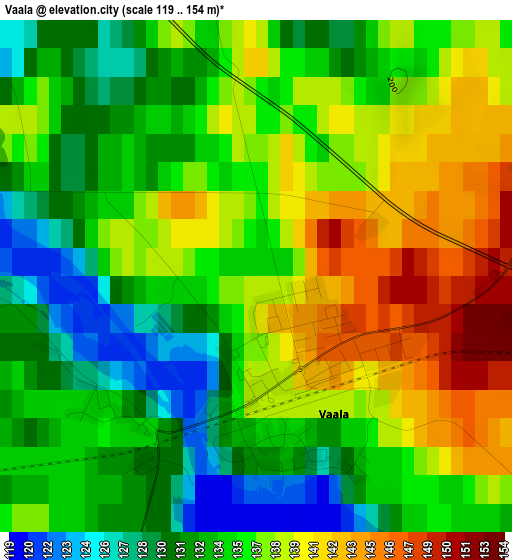
Below is the Elevation map of Vaala, which displays elevation range with different colors. Scale of the first map is from 119 to 154 m (390 to 505 ft) with average elevation of 135.6 meters (=445 ft) [note 1]
These maps also provides idea of topography and contour of this city, they are displayed at different zoom levels. More info about maps, scale and edge coordinates you can find below images.
| \ | Map #1 | Map #2 | Topo.Map |
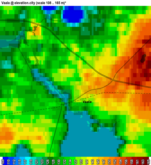
| Scale [m] | 119..154 m | 108..165 m | × |
| Scale [ft] | 390..505 ft | 354..541 ft | × |
| Average | 135.6 m = 445 ft | 134.8 m = 442 ft | × |
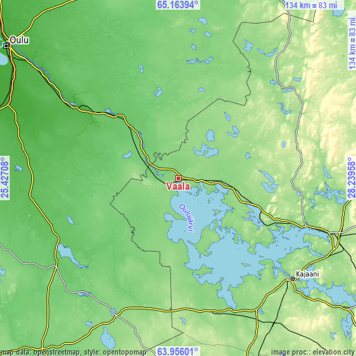
| Width | 4.2 km = 2.6 mi | 8.39 km = 5.2 mi | 134.3 km = 83.4 mi |
| Height | 4.2 km = 2.6 mi | 8.39 km = 5.2 mi | 134.3 km = 83.4 mi |
| ↑Max Latitude | 64.585536° | 64.604389° | 65.16394° |
| Latitude at center | 64.56667° | 64.56667° | 64.56667° |
| ↓Min Latitude | 64.547791° | 64.528898° | 63.95601° |
| ← Min Longitude | 26.789385° | 26.745439° | 25.42708° |
| Longitude center | 26.83333° | 26.83333° | 26.83333° |
| →Max Longitude | 26.877275° | 26.921221° | 28.23958° |
Nearby cities:
Cities around Vaala sort by population:
• Kajaani elevation 145 m
57.2 km,  131°
131°
• Muhos 30 m
48.1 km,  303°
303°
• Tyrnävä 20 m
60.3 km,  291°
291°
• Paltamo 150 m
50.7 km,  109°
109°
• Puolanka 167 m
51.8 km,  49°
49°
• Utajärvi 97 m
29.6 km,  313°
313°
• Vuolijoki 131 m
43.1 km,  169°
169°
• Rantsila 64 m
56.3 km,  263°
263°
• Pyhäntä 133 m
57.5 km,  205°
205°
• Pulkkila 81 m
57.2 km,  234°
234°
• Kestilä 104 m
35.9 km, 227°
• Muhos 62 m
41.4 km, 302°
Multilingual:
 En español:
Vaala elevación 138 m.
 En France:
Vaala élévation 138 m.


Sources and notes:
- [note 1] Map square and city borders are not equal. Map elevation data is calculated only from area inside that square.
- [src 1] Elevation data from geonames database provided with same terms of usage.
- [src 2] The elevation map of Vaala is generated using GMTED2010 database with 7.5 arcsec (225m) resolution.
- [src 3] Base (background) map © OpenStreetMap contributors tiles are generated by Geofabrik and OpenTopoMap.
Copyright & License:
This Vaala Elevation Map is licensed under CC BY-SA. You may reuse any part from this page, if you give a proper credit by linking to this URL:
 More info on terms of use page.