Barentu elevation
Barentu (Gash-Barka), Eritrea elevation is 1009 meters and Barentu elevation in feet is 3310 ft above sea level [src 1]. Barentu is a seat of a first-order administrative division (feature code) with elevation that is 176 meters (577 ft) smaller than average city elevation in Eritrea.
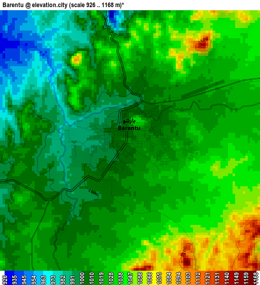
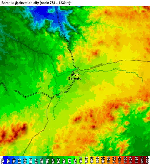
Below is the Elevation map of Barentu, which displays elevation range with different colors. Scale of the first map is from 926 to 1168 m (3038 to 3832 ft) with average elevation of 1018.7 meters (=3342 ft) [note 1]
These maps also provides idea of topography and contour of this city, they are displayed at different zoom levels. More info about maps, scale and edge coordinates you can find below images.
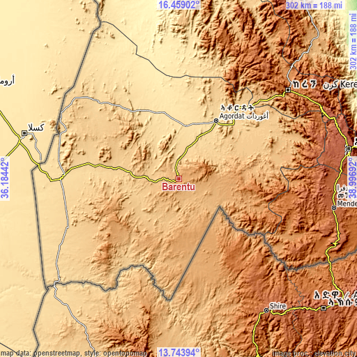
| \ | Map #1 | Map #2 | Topo.Map |
| Scale [m] | 926..1168 m | 763..1230 m | × |
| Scale [ft] | 3038..3832 ft | 2503..4035 ft | × |
| Average | 1018.7 m = 3342 ft | 1006.8 m = 3303 ft | × |
| Width | 9.43 km = 5.9 mi | 18.87 km = 11.7 mi | 301.9 km = 187.6 mi |
| Height | 9.43 km = 5.9 mi | 18.87 km = 11.7 mi | 301.9 km = 187.6 mi |
| ↑Max Latitude | 15.148243° | 15.190657° | 16.45902° |
| Latitude at center | 15.10582° | 15.10582° | 15.10582° |
| ↓Min Latitude | 15.063389° | 15.020949° | 13.74394° |
| ← Min Longitude | 37.546725° | 37.502779° | 36.18442° |
| Longitude center | 37.59067° | 37.59067° | 37.59067° |
| →Max Longitude | 37.634615° | 37.678561° | 38.99692° |
Nearby cities:
Cities around Barentu sort by population:
• Asmara elevation 2334 m
146.2 km,  79°
79°
• Keren 1399 m
118.7 km,  50°
50°
• Massawa 9 m
209.6 km,  74°
74°
• Mendefera 1977 m
133.8 km,  100°
100°
• Adi Keyh 2391 m
194.1 km, 98°
• Dek’emhāre 2019 m
156.5 km,  91°
91°
• Ak’ordat 612 m
58.3 km,  32°
32°
• Teseney 594 m
100.2 km,  270°
270°
• Mai-Mne 1849 m
115.6 km,  122°
122°
Multilingual:
 En español:
Barentu elevación 1009 m.
 En France:
Barentu élévation 1009 m.
 Auf Deutsch:
Barentu höhe über dem Meeresspiegel ist 1009 m.

Sources and notes:
- [note 1] Map square and city borders are not equal. Map elevation data is calculated only from area inside that square.
- [src 1] Elevation data from geonames database provided with same terms of usage.
- [src 2] The elevation map of Barentu is generated using elevation data from NASA's 3 arcsec (90m) resolution SRTM data.
- [src 3] Base (background) map © OpenStreetMap contributors tiles are generated by Geofabrik and OpenTopoMap.
Copyright & License:
This Barentu Elevation Map is licensed under CC BY-SA. You may reuse any part from this page, if you give a proper credit by linking to this URL:
 More info on terms of use page.