Akhmīm elevation
Akhmīm (Sohag), Egypt elevation is 85 meters and Akhmīm elevation in feet is 279 ft above sea level [src 1]. Akhmīm is a populated place (feature code) with elevation that is 41 meters (135 ft) bigger than average city elevation in Egypt.
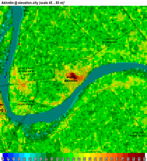
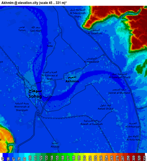
Below is the Elevation map of Akhmīm, which displays elevation range with different colors. Scale of the first map is from 45 to 85 m (148 to 279 ft) with average elevation of 62.1 meters (=204 ft) [note 1]
These maps also provides idea of topography and contour of this city, they are displayed at different zoom levels. More info about maps, scale and edge coordinates you can find below images.
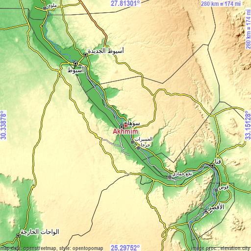
| \ | Map #1 | Map #2 | Topo.Map |
| Scale [m] | 45..85 m | 45..331 m | × |
| Scale [ft] | 148..279 ft | 148..1086 ft | × |
| Average | 62.1 m = 204 ft | 81.1 m = 266 ft | × |
| Width | 8.74 km = 5.4 mi | 17.48 km = 10.9 mi | 279.7 km = 173.8 mi |
| Height | 8.74 km = 5.4 mi | 17.48 km = 10.9 mi | 279.7 km = 173.8 mi |
| ↑Max Latitude | 26.60147° | 26.640757° | 27.81301° |
| Latitude at center | 26.56217° | 26.56217° | 26.56217° |
| ↓Min Latitude | 26.522856° | 26.483529° | 25.29752° |
| ← Min Longitude | 31.701085° | 31.657139° | 30.33878° |
| Longitude center | 31.74503° | 31.74503° | 31.74503° |
| →Max Longitude | 31.788975° | 31.832921° | 33.15128° |
Nearby cities:
Cities around Akhmīm sort by population:
• Asyūţ elevation 56 m
88.5 km,  321°
321°
• Sohag 67 m
5 km,  263°
263°
• Jirjā 70 m
28.9 km,  149°
149°
• Ţahţā 66 m
33.4 km,  313°
313°
• Abū Tīj 65 m
68.3 km, 321°
• Al Manshāh 72 m
11.1 km, 148°
• Dishnā 75 m
87.6 km,  123°
123°
• Farshūţ 78 m
70.1 km,  143°
143°
• Al Balyanā 75 m
44.5 km, 144°
• Juhaynah 64 m
27.5 km,  296°
296°
• Al Badārī 63 m
58 km,  325°
325°
• Naja' Ḥammādī 78 m
75.5 km, 139°
Multilingual:
 En español:
Akhmīm elevación 85 m.
 En France:
Akhmīm élévation 85 m.


Sources and notes:
- [note 1] Map square and city borders are not equal. Map elevation data is calculated only from area inside that square.
- [src 1] Elevation data from geonames database provided with same terms of usage.
- [src 2] The elevation map of Akhmīm is generated using elevation data from NASA's 3 arcsec (90m) resolution SRTM data.
- [src 3] Base (background) map © OpenStreetMap contributors tiles are generated by Geofabrik and OpenTopoMap.
Copyright & License:
This Akhmīm Elevation Map is licensed under CC BY-SA. You may reuse any part from this page, if you give a proper credit by linking to this URL:
 More info on terms of use page.