Al Fashn elevation
Al Fashn (Beni Suweif), Egypt elevation is 37 meters and Al Fashn elevation in feet is 121 ft above sea level [src 1]. Al Fashn is a populated place (feature code) with elevation that is 7 meters (23 ft) smaller than average city elevation in Egypt.
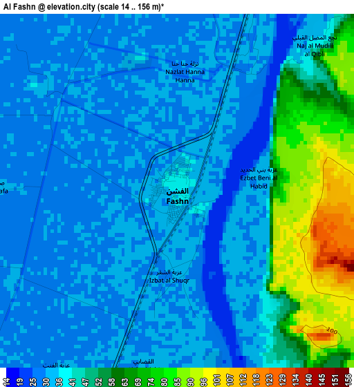
Below is the Elevation map of Al Fashn, which displays elevation range with different colors. Scale of the first map is from 14 to 156 m (46 to 512 ft) with average elevation of 42.1 meters (=138 ft) [note 1]
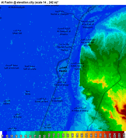
These maps also provides idea of topography and contour of this city, they are displayed at different zoom levels. More info about maps, scale and edge coordinates you can find below images.
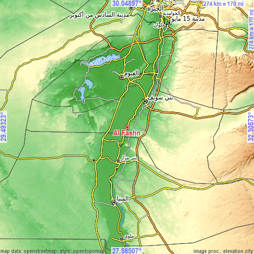
| \ | Map #1 | Map #2 | Topo.Map |
| Scale [m] | 14..156 m | 14..242 m | × |
| Scale [ft] | 46..512 ft | 46..794 ft | × |
| Average | 42.1 m = 138 ft | 49 m = 161 ft | × |
| Width | 8.56 km = 5.3 mi | 17.12 km = 10.6 mi | 274 km = 170.3 mi |
| Height | 8.56 km = 5.3 mi | 17.12 km = 10.6 mi | 274 km = 170.3 mi |
| ↑Max Latitude | 28.862803° | 28.901283° | 30.04897° |
| Latitude at center | 28.82431° | 28.82431° | 28.82431° |
| ↓Min Latitude | 28.785802° | 28.74728° | 27.58507° |
| ← Min Longitude | 30.855535° | 30.811589° | 29.49323° |
| Longitude center | 30.89948° | 30.89948° | 30.89948° |
| →Max Longitude | 30.943425° | 30.987371° | 32.30573° |
Nearby cities:
Cities around Al Fashn sort by population:
• Al Fayyūm elevation 29 m
54.3 km,  354°
354°
• Al Minyā 49 m
80.8 km,  190°
190°
• Banī Suwayf 33 m
33.9 km,  34°
34°
• Samālūţ 41 m
59.9 km,  197°
197°
• Būsh 31 m
42.3 km, 31°
• Banī Mazār 43 m
36.9 km, 195°
• Ibshawāy 11 m
63.1 km,  340°
340°
• Ţāmiyah -6 m
72.8 km,  4°
4°
• Iţsā 20 m
47.2 km, 346°
• Maţāy 40 m
46.6 km, 194°
• Al Wāsiţah 33 m
64.4 km, 27°
• Sumusţā as Sulţānī 28 m
11.3 km,  334°
334°
Multilingual:
 En español:
Al Fashn elevación 37 m.
 En France:
Al Fashn élévation 37 m.


Sources and notes:
- [note 1] Map square and city borders are not equal. Map elevation data is calculated only from area inside that square.
- [src 1] Elevation data from geonames database provided with same terms of usage.
- [src 2] The elevation map of Al Fashn is generated using elevation data from NASA's 3 arcsec (90m) resolution SRTM data.
- [src 3] Base (background) map © OpenStreetMap contributors tiles are generated by Geofabrik and OpenTopoMap.
Copyright & License:
This Al Fashn Elevation Map is licensed under CC BY-SA. You may reuse any part from this page, if you give a proper credit by linking to this URL:
 More info on terms of use page.