Dahab elevation
Dahab (South Sinai), Egypt elevation is 13 meters and Dahab elevation in feet is 43 ft above sea level [src 1]. Dahab is a populated place (feature code) with elevation that is 31 meters (102 ft) smaller than average city elevation in Egypt.
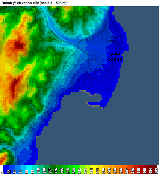
Below is the Elevation map of Dahab, which displays elevation range with different colors. Scale of the first map is from 3 to 503 m (10 to 1650 ft) with average elevation of 147.9 meters (=485 ft) [note 1]
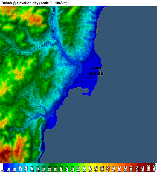
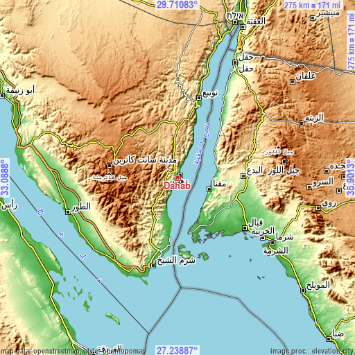
These maps also provides idea of topography and contour of this city, they are displayed at different zoom levels. More info about maps, scale and edge coordinates you can find below images.
| \ | Map #1 | Map #2 | Topo.Map |
| Scale [m] | 3..503 m | 0..1043 m | × |
| Scale [ft] | 10..1650 ft | 0..3422 ft | × |
| Average | 147.9 m = 485 ft | 314.8 m = 1033 ft | × |
| Width | 8.59 km = 5.3 mi | 17.18 km = 10.7 mi | 274.9 km = 170.8 mi |
| Height | 8.59 km = 5.3 mi | 17.18 km = 10.7 mi | 274.9 km = 170.8 mi |
| ↑Max Latitude | 28.520699° | 28.559305° | 29.71083° |
| Latitude at center | 28.48208° | 28.48208° | 28.48208° |
| ↓Min Latitude | 28.443446° | 28.404799° | 27.23887° |
| ← Min Longitude | 34.451105° | 34.407159° | 33.0888° |
| Longitude center | 34.49505° | 34.49505° | 34.49505° |
| →Max Longitude | 34.538995° | 34.582941° | 35.9013° |
Nearby cities:
Cities around Dahab sort by population:
• Suez elevation 11 m
253 km,  310°
310°
• Hurghada 11 m
151.8 km,  206°
206°
• Ain Sukhna 30 m
245.5 km,  300°
300°
• Safaga 13 m
200.3 km,  195°
195°
• Ras Gharib 16 m
139.2 km,  264°
264°
• Al Quşayr 21 m
265.3 km,  184°
184°
• El Gouna 8 m
145.2 km, 213°
• El-Tor 14 m
89.5 km,  252°
252°
• Sharm el-Sheikh 11 m
65 km,  194°
194°
• Nuwaybi‘a 11 m
64.9 km,  14°
14°
• Saint Catherine 1565 m
54 km,  279°
279°
• Makadi Bay 5 m
175.8 km, 199°
Multilingual:
 En español:
Dahab elevación 13 m.
 En France:
Dahab élévation 13 m.


Sources and notes:
- [note 1] Map square and city borders are not equal. Map elevation data is calculated only from area inside that square.
- [src 1] Elevation data from geonames database provided with same terms of usage.
- [src 2] The elevation map of Dahab is generated using elevation data from NASA's 3 arcsec (90m) resolution SRTM data.
- [src 3] Base (background) map © OpenStreetMap contributors tiles are generated by Geofabrik and OpenTopoMap.
Copyright & License:
This Dahab Elevation Map is licensed under CC BY-SA. You may reuse any part from this page, if you give a proper credit by linking to this URL:
 More info on terms of use page.