Jõgeva elevation
Jõgeva (Jõgevamaa, Jõgeva vald), Estonia elevation is 79 meters and Jõgeva elevation in feet is 259 ft above sea level [src 1]. Jõgeva is a seat of a first-order administrative division (feature code) with elevation that is 28 meters (92 ft) bigger than average city elevation in Estonia.
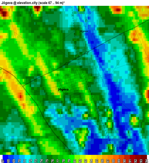
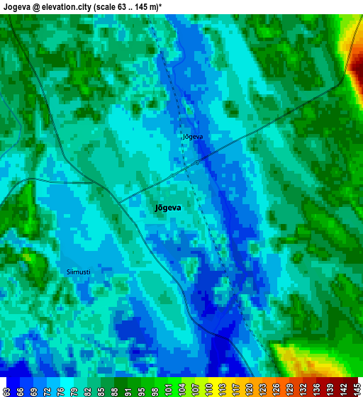
Below is the Elevation map of Jõgeva, which displays elevation range with different colors. Scale of the first map is from 67 to 94 m (220 to 308 ft) with average elevation of 76.1 meters (=250 ft) [note 1]
These maps also provides idea of topography and contour of this city, they are displayed at different zoom levels. More info about maps, scale and edge coordinates you can find below images.
| \ | Map #1 | Map #2 | Topo.Map |
| Scale [m] | 67..94 m | 63..145 m | × |
| Scale [ft] | 220..308 ft | 207..476 ft | × |
| Average | 76.1 m = 250 ft | 81.3 m = 267 ft | × |
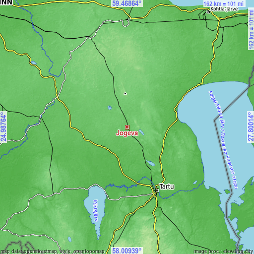
| Width | 5.07 km = 3.2 mi | 10.14 km = 6.3 mi | 162.3 km = 100.8 mi |
| Height | 5.07 km = 3.2 mi | 10.14 km = 6.3 mi | 162.2 km = 100.8 mi |
| ↑Max Latitude | 58.769462° | 58.79224° | 59.46864° |
| Latitude at center | 58.74667° | 58.74667° | 58.74667° |
| ↓Min Latitude | 58.723863° | 58.70104° | 58.00939° |
| ← Min Longitude | 26.349945° | 26.305999° | 24.98764° |
| Longitude center | 26.39389° | 26.39389° | 26.39389° |
| →Max Longitude | 26.437835° | 26.481781° | 27.80014° |
Nearby cities:
Cities around Jõgeva sort by population:
• Tartu elevation 39 m
45 km,  154°
154°
• Põltsamaa 69 m
26.6 km,  246°
246°
• Tamsalu 126 m
48.5 km,  340°
340°
• Väike-Maarja 121 m
43 km,  348°
348°
• Mustvee 39 m
33.4 km,  70°
70°
• Koeru 102 m
31.9 km,  319°
319°
• Kallaste 43 m
45.3 km,  101°
101°
• Puhja 59 m
45.2 km,  185°
185°
• Järva-Jaani 103 m
43.6 km, 318°
• Rakke 104 m
27.3 km, 342°
• Kõrveküla 68 m
42.3 km, 147°
• Alatskivi 48 m
45.8 km,  111°
111°
Multilingual:
 En español:
Jõgeva elevación 79 m.
 En France:
Jõgeva élévation 79 m.


Sources and notes:
- [note 1] Map square and city borders are not equal. Map elevation data is calculated only from area inside that square.
- [src 1] Elevation data from geonames database provided with same terms of usage.
- [src 2] The elevation map of Jõgeva is generated using elevation data from NASA's 3 arcsec (90m) resolution SRTM data.
- [src 3] Base (background) map © OpenStreetMap contributors tiles are generated by Geofabrik and OpenTopoMap.
Copyright & License:
This Jõgeva Elevation Map is licensed under CC BY-SA. You may reuse any part from this page, if you give a proper credit by linking to this URL:
 More info on terms of use page.