Rakvere elevation
Rakvere (Lääne-Virumaa, Rakvere linn), Estonia elevation is 84 meters and Rakvere elevation in feet is 276 ft above sea level [src 1]. Rakvere is a seat of a first-order administrative division (feature code) with elevation that is 33 meters (108 ft) bigger than average city elevation in Estonia.
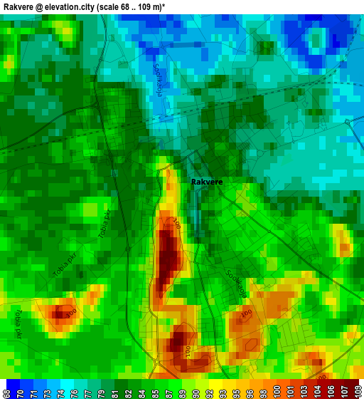
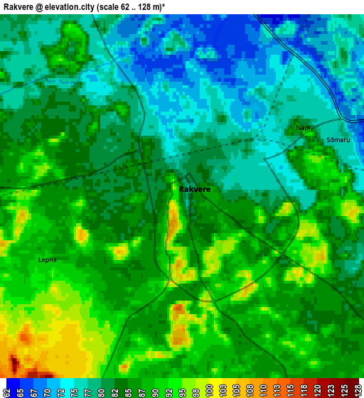
Below is the Elevation map of Rakvere, which displays elevation range with different colors. Scale of the first map is from 68 to 109 m (223 to 358 ft) with average elevation of 83.6 meters (=274 ft) [note 1]
These maps also provides idea of topography and contour of this city, they are displayed at different zoom levels. More info about maps, scale and edge coordinates you can find below images.
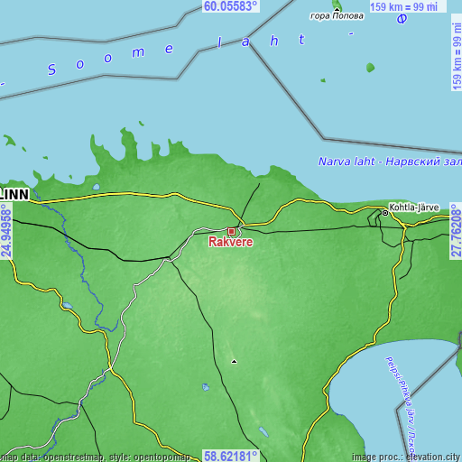
| \ | Map #1 | Map #2 | Topo.Map |
| Scale [m] | 68..109 m | 62..128 m | × |
| Scale [ft] | 223..358 ft | 203..420 ft | × |
| Average | 83.6 m = 274 ft | 84 m = 276 ft | × |
| Width | 4.98 km = 3.1 mi | 9.97 km = 6.2 mi | 159.4 km = 99 mi |
| Height | 4.98 km = 3.1 mi | 9.96 km = 6.2 mi | 159.4 km = 99 mi |
| ↑Max Latitude | 59.368788° | 59.391171° | 60.05583° |
| Latitude at center | 59.34639° | 59.34639° | 59.34639° |
| ↓Min Latitude | 59.323977° | 59.30155° | 58.62181° |
| ← Min Longitude | 26.311885° | 26.267939° | 24.94958° |
| Longitude center | 26.35583° | 26.35583° | 26.35583° |
| →Max Longitude | 26.399775° | 26.443721° | 27.76208° |
Nearby cities:
Cities around Rakvere sort by population:
• Tapa elevation 103 m
24.5 km,  247°
247°
• Kunda 46 m
18.2 km,  33°
33°
• Tamsalu 126 m
25 km,  213°
213°
• Kadrina 93 m
12 km,  263°
263°
• Väike-Maarja 121 m
25.2 km,  193°
193°
• Aseri 35 m
31.2 km,  68°
68°
• Sõmeru 75 m
4.9 km, 70°
• Haljala 80 m
11.1 km,  331°
331°
• Vinni 95 m
7.1 km,  142°
142°
• Pajusti 107 m
8.9 km,  154°
154°
• Vaiatu 94 m
20.5 km,  272°
272°
• Kunda 46 m
19.5 km, 29°
Multilingual:
 En español:
Rakvere elevación 84 m.
 En France:
Rakvere élévation 84 m.
 Auf Deutsch:
Wesenberg, Rakvere höhe über dem Meeresspiegel ist 84 m.

Sources and notes:
- [note 1] Map square and city borders are not equal. Map elevation data is calculated only from area inside that square.
- [src 1] Elevation data from geonames database provided with same terms of usage.
- [src 2] The elevation map of Rakvere is generated using elevation data from NASA's 3 arcsec (90m) resolution SRTM data.
- [src 3] Base (background) map © OpenStreetMap contributors tiles are generated by Geofabrik and OpenTopoMap.
Copyright & License:
This Rakvere Elevation Map is licensed under CC BY-SA. You may reuse any part from this page, if you give a proper credit by linking to this URL:
 More info on terms of use page.