Võru elevation
Võru (Võrumaa, Võru linn), Estonia elevation is 76 meters and Võru elevation in feet is 249 ft above sea level [src 1]. Võru is a seat of a first-order administrative division (feature code) with elevation that is 25 meters (82 ft) bigger than average city elevation in Estonia.
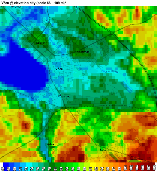
Below is the Elevation map of Võru, which displays elevation range with different colors. Scale of the first map is from 66 to 109 m (217 to 358 ft) with average elevation of 82.7 meters (=271 ft) [note 1]
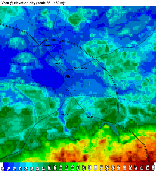
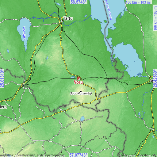
These maps also provides idea of topography and contour of this city, they are displayed at different zoom levels. More info about maps, scale and edge coordinates you can find below images.
| \ | Map #1 | Map #2 | Topo.Map |
| Scale [m] | 66..109 m | 66..180 m | × |
| Scale [ft] | 217..358 ft | 217..591 ft | × |
| Average | 82.7 m = 271 ft | 91.5 m = 300 ft | × |
| Width | 5.2 km = 3.2 mi | 10.41 km = 6.5 mi | 166.5 km = 103.5 mi |
| Height | 5.2 km = 3.2 mi | 10.41 km = 6.5 mi | 166.5 km = 103.5 mi |
| ↑Max Latitude | 57.857278° | 57.88065° | 58.5748° |
| Latitude at center | 57.83389° | 57.83389° | 57.83389° |
| ↓Min Latitude | 57.810487° | 57.787069° | 57.07743° |
| ← Min Longitude | 26.975495° | 26.931549° | 25.61319° |
| Longitude center | 27.01944° | 27.01944° | 27.01944° |
| →Max Longitude | 27.063385° | 27.107331° | 28.42569° |
Nearby cities:
Cities around Võru sort by population:
• Valga elevation 64 m
57.9 km,  263°
263°
• Põlva 63 m
25.3 km,  6°
6°
• Elva 51 m
55.7 km,  320°
320°
• Räpina 43 m
39.4 km,  41°
41°
• Nõo 61 m
56.7 km,  330°
330°
• Vana-Antsla 86 m
29 km,  277°
277°
• Ülenurme 52 m
56.3 km,  342°
342°
• Kanepi 131 m
22.7 km, 316°
• Värska 46 m
39.1 km,  69°
69°
• Rõuge 133 m
13.5 km,  208°
208°
• Kurepalu 60 m
54.9 km,  348°
348°
• Antsla 85 m
28.4 km,  268°
268°
Multilingual:
 En español:
Võru elevación 76 m.
 En France:
Võru élévation 76 m.


Sources and notes:
- [note 1] Map square and city borders are not equal. Map elevation data is calculated only from area inside that square.
- [src 1] Elevation data from geonames database provided with same terms of usage.
- [src 2] The elevation map of Võru is generated using elevation data from NASA's 3 arcsec (90m) resolution SRTM data.
- [src 3] Base (background) map © OpenStreetMap contributors tiles are generated by Geofabrik and OpenTopoMap.
Copyright & License:
This Võru Elevation Map is licensed under CC BY-SA. You may reuse any part from this page, if you give a proper credit by linking to this URL:
 More info on terms of use page.