El Ángel elevation
El Ángel (Carchi, Cantón Espejo), Ecuador elevation is 3008 meters and El Ángel elevation in feet is 9869 ft above sea level [src 1]. El Ángel is a populated place (feature code) with elevation that is 2063 meters (6768 ft) bigger than average city elevation in Ecuador.
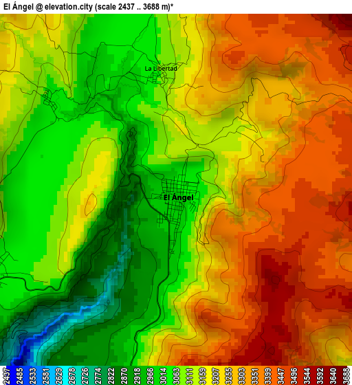
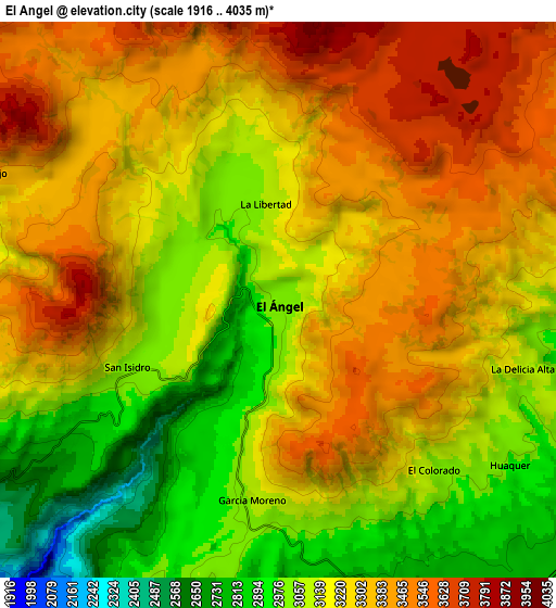
Below is the Elevation map of El Ángel, which displays elevation range with different colors. Scale of the first map is from 2437 to 3688 m (7995 to 12100 ft) with average elevation of 3178.4 meters (=10428 ft) [note 1]
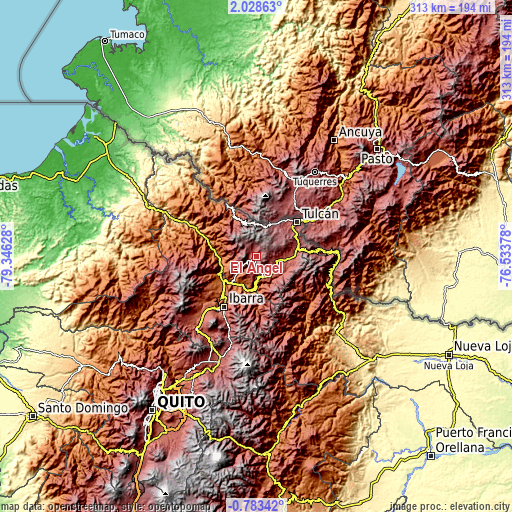
These maps also provides idea of topography and contour of this city, they are displayed at different zoom levels. More info about maps, scale and edge coordinates you can find below images.
| \ | Map #1 | Map #2 | Topo.Map |
| Scale [m] | 2437..3688 m | 1916..4035 m | × |
| Scale [ft] | 7995..12100 ft | 6286..13238 ft | × |
| Average | 3178.4 m = 10428 ft | 3223.6 m = 10576 ft | × |
| Width | 9.77 km = 6.1 mi | 19.54 km = 12.1 mi | 312.7 km = 194.3 mi |
| Height | 9.77 km = 6.1 mi | 19.54 km = 12.1 mi | 312.7 km = 194.3 mi |
| ↑Max Latitude | 0.666733° | 0.710675° | 2.02863° |
| Latitude at center | 0.62279° | 0.62279° | 0.62279° |
| ↓Min Latitude | 0.578847° | 0.534904° | -0.78342° |
| ← Min Longitude | -77.983975° | -78.027921° | -79.34628° |
| Longitude center | -77.94003° | -77.94003° | -77.94003° |
| →Max Longitude | -77.896085° | -77.852139° | -76.53378° |
Nearby cities:
Cities around El Ángel sort by population:
• Quito elevation 2854 m
115 km,  214°
214°
• Tutamandahostel 2804 m
110.3 km, 214°
• Ibarra 2208 m
36.3 km, 213°
• Tulcán 2962 m
32.5 km,  49°
49°
• Otavalo 2532 m
56.1 km,  219°
219°
• Cayambe 2814 m
68.6 km,  199°
199°
• Atuntaqui 2413 m
44.4 km, 223°
• San Gabriel 2860 m
12.6 km,  105°
105°
• Cotacachi 2442 m
50.8 km,  225°
225°
• Pimampiro 2149 m
25.8 km,  180°
180°
• Sangolquí 2513 m
120.7 km, 208°
• Gonzalo Pizarro 576 m
91.8 km,  137°
137°
Multilingual:
 En español:
El Ángel elevación 3008 m.
 En France:
El Ángel élévation 3008 m.
 Auf Deutsch:
El Ángel höhe über dem Meeresspiegel ist 3008 m.

Sources and notes:
- [note 1] Map square and city borders are not equal. Map elevation data is calculated only from area inside that square.
- [src 1] Elevation data from geonames database provided with same terms of usage.
- [src 2] The elevation map of El Ángel is generated using elevation data from NASA's 3 arcsec (90m) resolution SRTM data.
- [src 3] Base (background) map © OpenStreetMap contributors tiles are generated by Geofabrik and OpenTopoMap.
Copyright & License:
This El Ángel Elevation Map is licensed under CC BY-SA. You may reuse any part from this page, if you give a proper credit by linking to this URL:
 More info on terms of use page.