Santa Elena elevation
Santa Elena, Ecuador elevation is 43 meters and Santa Elena elevation in feet is 141 ft above sea level [src 1]. Santa Elena is a seat of a first-order administrative division (feature code) with elevation that is 902 meters (2959 ft) smaller than average city elevation in Ecuador.
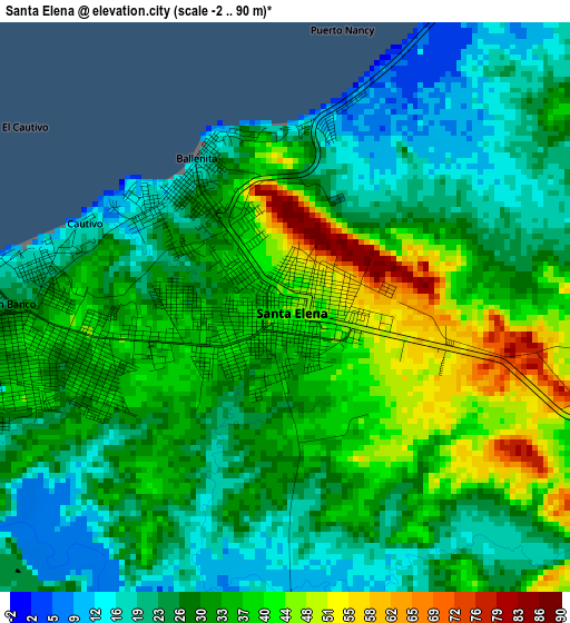
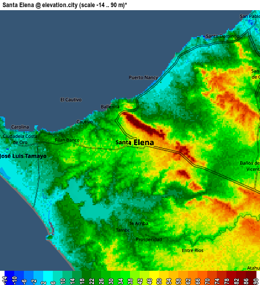
Below is the Elevation map of Santa Elena, which displays elevation range with different colors. Scale of the first map is from -2 to 90 m (-7 to 295 ft) with average elevation of 31.1 meters (=102 ft) [note 1]
These maps also provides idea of topography and contour of this city, they are displayed at different zoom levels. More info about maps, scale and edge coordinates you can find below images.
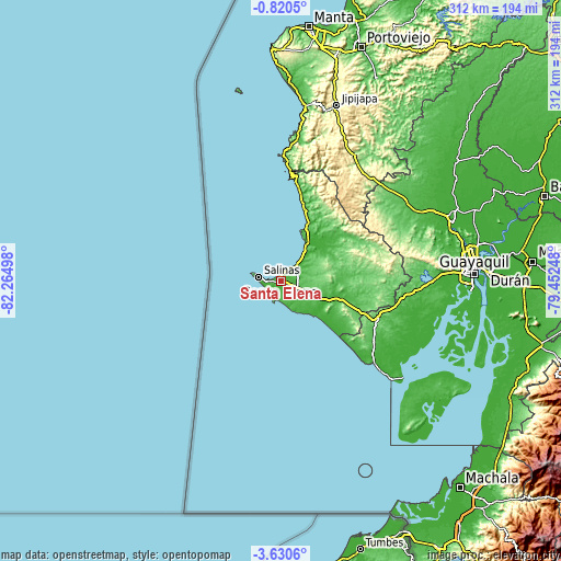
| \ | Map #1 | Map #2 | Topo.Map |
| Scale [m] | -2..90 m | -14..90 m | × |
| Scale [ft] | -7..295 ft | -46..295 ft | × |
| Average | 31.1 m = 102 ft | 30.6 m = 100 ft | × |
| Width | 9.77 km = 6.1 mi | 19.53 km = 12.1 mi | 312.5 km = 194.2 mi |
| Height | 9.77 km = 6.1 mi | 19.53 km = 12.1 mi | 312.5 km = 194.2 mi |
| ↑Max Latitude | -2.182307° | -2.138393° | -0.8205° |
| Latitude at center | -2.22622° | -2.22622° | -2.22622° |
| ↓Min Latitude | -2.270131° | -2.314042° | -3.6306° |
| ← Min Longitude | -80.902675° | -80.946621° | -82.26498° |
| Longitude center | -80.85873° | -80.85873° | -80.85873° |
| →Max Longitude | -80.814785° | -80.770839° | -79.45248° |
Nearby cities:
Cities around Santa Elena sort by population:
• Guayaquil elevation 1 m
108.1 km,  88°
88°
• Eloy Alfaro 7 m
111.6 km, 87°
• La Libertad 28 m
5.8 km,  262°
262°
• Salinas 12 m
10.4 km,  277°
277°
• Jipijapa 287 m
102.4 km,  17°
17°
• El Triunfo 6 m
104.3 km,  71°
71°
• Playas 10 m
69.1 km,  130°
130°
• Pedro Carbo 56 m
83.2 km,  56°
56°
• Sucre 121 m
116 km, 24°
• Santa Lucía 15 m
95.5 km, 87°
• Paján 125 m
88.8 km,  32°
32°
• Lomas de Sargentillo 21 m
94.2 km, 66°
Multilingual:
 En español:
Santa Elena elevación 43 m.
 En France:
Santa Elena élévation 43 m.
 Auf Deutsch:
Santa Elena höhe über dem Meeresspiegel ist 43 m.

Sources and notes:
- [note 1] Map square and city borders are not equal. Map elevation data is calculated only from area inside that square.
- [src 1] Elevation data from geonames database provided with same terms of usage.
- [src 2] The elevation map of Santa Elena is generated using elevation data from NASA's 3 arcsec (90m) resolution SRTM data.
- [src 3] Base (background) map © OpenStreetMap contributors tiles are generated by Geofabrik and OpenTopoMap.
Copyright & License:
This Santa Elena Elevation Map is licensed under CC BY-SA. You may reuse any part from this page, if you give a proper credit by linking to this URL:
 More info on terms of use page.