Aïn el Bya elevation
Aïn el Bya (Oran), Algeria elevation is 63 meters and Aïn el Bya elevation in feet is 207 ft above sea level [src 1]. Aïn el Bya is a populated place (feature code) with elevation that is 375 meters (1230 ft) smaller than average city elevation in Algeria.
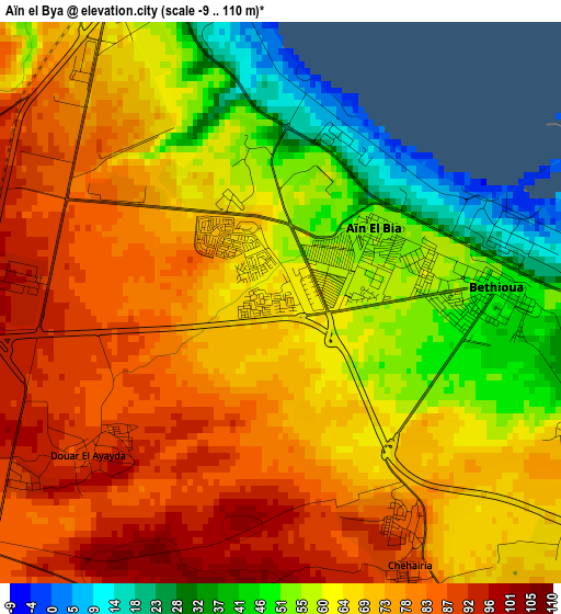
Below is the Elevation map of Aïn el Bya, which displays elevation range with different colors. Scale of the first map is from -9 to 110 m (-30 to 361 ft) with average elevation of 68 meters (=223 ft) [note 1]
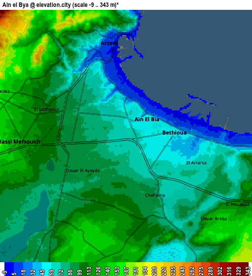
These maps also provides idea of topography and contour of this city, they are displayed at different zoom levels. More info about maps, scale and edge coordinates you can find below images.
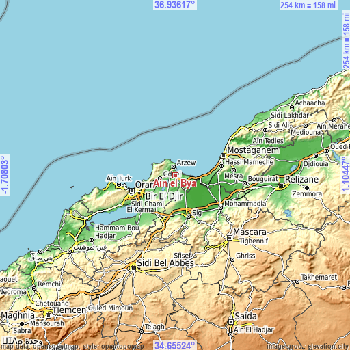
| \ | Map #1 | Map #2 | Topo.Map |
| Scale [m] | -9..110 m | -9..343 m | × |
| Scale [ft] | -30..361 ft | -30..1125 ft | × |
| Average | 68 m = 223 ft | 94.9 m = 311 ft | × |
| Width | 7.93 km = 4.9 mi | 15.85 km = 9.8 mi | 253.6 km = 157.6 mi |
| Height | 7.93 km = 4.9 mi | 15.85 km = 9.8 mi | 253.6 km = 157.6 mi |
| ↑Max Latitude | 35.839523° | 35.875139° | 36.93617° |
| Latitude at center | 35.80389° | 35.80389° | 35.80389° |
| ↓Min Latitude | 35.768241° | 35.732577° | 34.65524° |
| ← Min Longitude | -0.345725° | -0.389671° | -1.70803° |
| Longitude center | -0.30178° | -0.30178° | -0.30178° |
| →Max Longitude | -0.257835° | -0.213889° | 1.10447° |
Nearby cities:
Cities around Aïn el Bya sort by population:
• Oran elevation 118 m
32.3 km,  248°
248°
• Mascara 590 m
60.4 km,  138°
138°
• Mostaganem 102 m
38 km,  68°
68°
• Es Senia 88 m
33.9 km,  239°
239°
• Bir el Djir 162 m
23.8 km, 246°
• Sig 62 m
32.2 km,  162°
162°
• ’Aïn el Turk 31 m
42.7 km,  260°
260°
• Sidi ech Chahmi 92 m
25.6 km,  230°
230°
• Bou Hanifia el Hamamat 232 m
59 km, 157°
• Bou Tlelis 103 m
59.8 km, 244°
• Mers el Kebir 22 m
37.6 km, 257°
• ’Aïn el Berd 483 m
52.5 km,  201°
201°
Multilingual:
 En español:
Aïn el Bya elevación 63 m.
 En France:
Aïn el Bya élévation 63 m.
 Auf Deutsch:
Aïn el Bya höhe über dem Meeresspiegel ist 63 m.

Sources and notes:
- [note 1] Map square and city borders are not equal. Map elevation data is calculated only from area inside that square.
- [src 1] Elevation data from geonames database provided with same terms of usage.
- [src 2] The elevation map of Aïn el Bya is generated using elevation data from NASA's 3 arcsec (90m) resolution SRTM data.
- [src 3] Base (background) map © OpenStreetMap contributors tiles are generated by Geofabrik and OpenTopoMap.
Copyright & License:
This Aïn el Bya Elevation Map is licensed under CC BY-SA. You may reuse any part from this page, if you give a proper credit by linking to this URL:
 More info on terms of use page.