Batna elevation
Batna, Algeria elevation is 1037 meters and Batna elevation in feet is 3402 ft above sea level [src 1]. Batna is a seat of a first-order administrative division (feature code) with elevation that is 599 meters (1965 ft) bigger than average city elevation in Algeria.
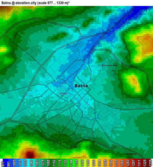
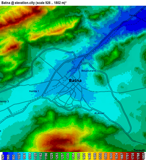
Below is the Elevation map of Batna, which displays elevation range with different colors. Scale of the first map is from 977 to 1339 m (3205 to 4393 ft) with average elevation of 1080.1 meters (=3544 ft) [note 1]
These maps also provides idea of topography and contour of this city, they are displayed at different zoom levels. More info about maps, scale and edge coordinates you can find below images.
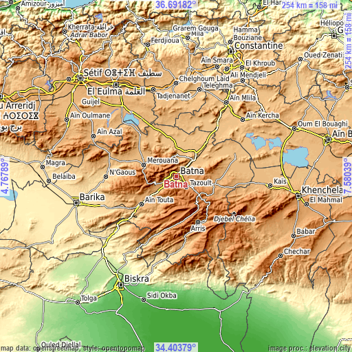
| \ | Map #1 | Map #2 | Topo.Map |
| Scale [m] | 977..1339 m | 926..1802 m | × |
| Scale [ft] | 3205..4393 ft | 3038..5912 ft | × |
| Average | 1080.1 m = 3544 ft | 1190.6 m = 3906 ft | × |
| Width | 7.95 km = 4.9 mi | 15.9 km = 9.9 mi | 254.4 km = 158.1 mi |
| Height | 7.95 km = 4.9 mi | 15.9 km = 9.9 mi | 254.4 km = 158.1 mi |
| ↑Max Latitude | 35.591714° | 35.627441° | 36.69182° |
| Latitude at center | 35.55597° | 35.55597° | 35.55597° |
| ↓Min Latitude | 35.52021° | 35.484435° | 34.40379° |
| ← Min Longitude | 6.130195° | 6.086249° | 4.76789° |
| Longitude center | 6.17414° | 6.17414° | 6.17414° |
| →Max Longitude | 6.218085° | 6.262031° | 7.58039° |
Nearby cities:
Cities around Batna sort by population:
• El Eulma elevation 959 m
79.4 km,  326°
326°
• Barika 476 m
75.5 km,  255°
255°
• Aïn Touta 925 m
31.8 km,  231°
231°
• Chelghoum el Aïd 766 m
67.5 km,  359°
359°
• Aïn Fakroun 953 m
78.2 km,  53°
53°
• Telerghma 748 m
64.4 km,  14°
14°
• Merouana 992 m
25.1 km,  289°
289°
• Tazoult-Lambese 1205 m
11.4 km,  136°
136°
• Arris 1205 m
36.6 km,  154°
154°
• Râs el Aïoun 862 m
49.6 km, 285°
• Aïn Kercha 819 m
62.4 km, 48°
• Boumagueur 678 m
56.5 km, 264°
Multilingual:
 En español:
Batna elevación 1037 m.
 En France:
Batna élévation 1037 m.


Sources and notes:
- [note 1] Map square and city borders are not equal. Map elevation data is calculated only from area inside that square.
- [src 1] Elevation data from geonames database provided with same terms of usage.
- [src 2] The elevation map of Batna is generated using elevation data from NASA's 3 arcsec (90m) resolution SRTM data.
- [src 3] Base (background) map © OpenStreetMap contributors tiles are generated by Geofabrik and OpenTopoMap.
Copyright & License:
This Batna Elevation Map is licensed under CC BY-SA. You may reuse any part from this page, if you give a proper credit by linking to this URL:
 More info on terms of use page.