Kolea elevation
Kolea (Tipaza), Algeria elevation is 137 meters and Kolea elevation in feet is 449 ft above sea level [src 1]. Kolea is a populated place (feature code) with elevation that is 301 meters (988 ft) smaller than average city elevation in Algeria.
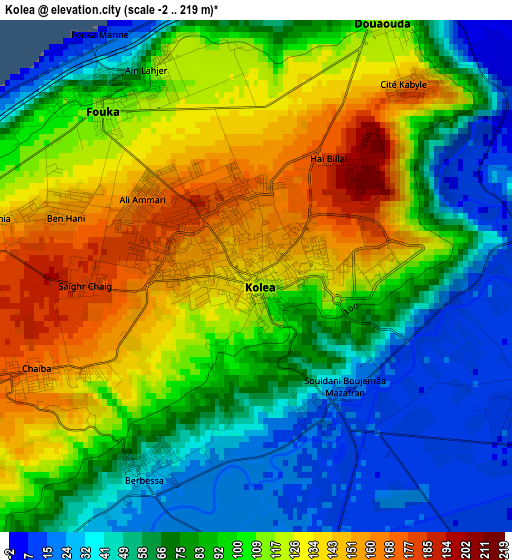
Below is the Elevation map of Kolea, which displays elevation range with different colors. Scale of the first map is from -2 to 219 m (-7 to 719 ft) with average elevation of 92.4 meters (=303 ft) [note 1]
These maps also provides idea of topography and contour of this city, they are displayed at different zoom levels. More info about maps, scale and edge coordinates you can find below images.
| \ | Map #1 | Map #2 | Topo.Map |
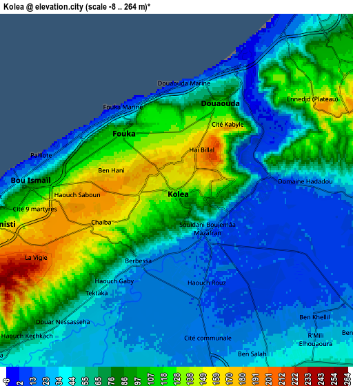
| Scale [m] | -2..219 m | -8..264 m | × |
| Scale [ft] | -7..719 ft | -26..866 ft | × |
| Average | 92.4 m = 303 ft | 68.6 m = 225 ft | × |
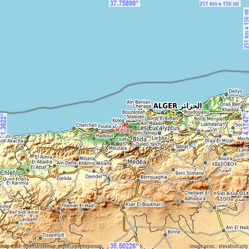
| Width | 7.84 km = 4.9 mi | 15.68 km = 9.7 mi | 250.9 km = 155.9 mi |
| Height | 7.84 km = 4.9 mi | 15.68 km = 9.7 mi | 250.9 km = 155.9 mi |
| ↑Max Latitude | 36.674134° | 36.709372° | 37.75898° |
| Latitude at center | 36.63888° | 36.63888° | 36.63888° |
| ↓Min Latitude | 36.60361° | 36.568323° | 35.50226° |
| ← Min Longitude | 2.724505° | 2.680559° | 1.3622° |
| Longitude center | 2.76845° | 2.76845° | 2.76845° |
| →Max Longitude | 2.812395° | 2.856341° | 4.1747° |
Nearby cities:
Cities around Kolea sort by population:
• Blida elevation 256 m
19.5 km,  164°
164°
• Beni Mered 136 m
15.2 km,  147°
147°
• Boufarik 49 m
14.7 km,  119°
119°
• Boû Arfa 241 m
20 km,  168°
168°
• Souma 151 m
18.1 km,  137°
137°
• Mouzaïa 121 m
20.4 km,  200°
200°
• Cheraga 171 m
22.2 km,  49°
49°
• Douera 178 m
16.1 km,  77°
77°
• Chiffa 110 m
19.7 km,  187°
187°
• Bou Ismaïl 29 m
7 km,  273°
273°
• Oued el Alleug 47 m
9.5 km, 168°
• Zeralda 30 m
10.4 km,  39°
39°
Multilingual:
 En español:
Kolea elevación 137 m.
 En France:
Kolea élévation 137 m.


Sources and notes:
- [note 1] Map square and city borders are not equal. Map elevation data is calculated only from area inside that square.
- [src 1] Elevation data from geonames database provided with same terms of usage.
- [src 2] The elevation map of Kolea is generated using elevation data from NASA's 3 arcsec (90m) resolution SRTM data.
- [src 3] Base (background) map © OpenStreetMap contributors tiles are generated by Geofabrik and OpenTopoMap.
Copyright & License:
This Kolea Elevation Map is licensed under CC BY-SA. You may reuse any part from this page, if you give a proper credit by linking to this URL:
 More info on terms of use page.