Ouargla elevation
Ouargla, Algeria elevation is 138 meters and Ouargla elevation in feet is 453 ft above sea level [src 1]. Ouargla is a seat of a first-order administrative division (feature code) with elevation that is 300 meters (984 ft) smaller than average city elevation in Algeria.
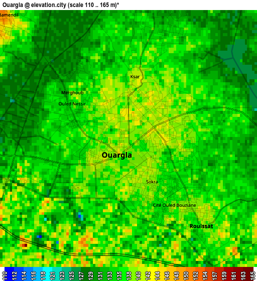
Below is the Elevation map of Ouargla, which displays elevation range with different colors. Scale of the first map is from 110 to 165 m (361 to 541 ft) with average elevation of 135.1 meters (=443 ft) [note 1]
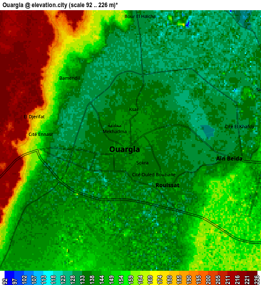
These maps also provides idea of topography and contour of this city, they are displayed at different zoom levels. More info about maps, scale and edge coordinates you can find below images.
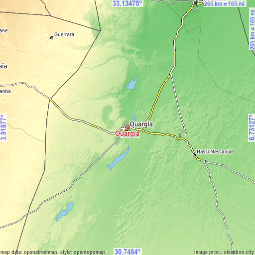
| \ | Map #1 | Map #2 | Topo.Map |
| Scale [m] | 110..165 m | 92..226 m | × |
| Scale [ft] | 361..541 ft | 302..741 ft | × |
| Average | 135.1 m = 443 ft | 149 m = 489 ft | × |
| Width | 8.29 km = 5.2 mi | 16.58 km = 10.3 mi | 265.3 km = 164.8 mi |
| Height | 8.29 km = 5.2 mi | 16.58 km = 10.3 mi | 265.3 km = 164.8 mi |
| ↑Max Latitude | 31.986601° | 32.023866° | 33.13475° |
| Latitude at center | 31.94932° | 31.94932° | 31.94932° |
| ↓Min Latitude | 31.912024° | 31.874713° | 30.7484° |
| ← Min Longitude | 5.281075° | 5.237129° | 3.91877° |
| Longitude center | 5.32502° | 5.32502° | 5.32502° |
| →Max Longitude | 5.368965° | 5.412911° | 6.73127° |
Nearby cities:
Cities around Ouargla sort by population:
• Ghardaïa elevation 503 m
166.6 km,  291°
291°
• Rouissat 138 m
3.7 km,  139°
139°
• Hassi Messaoud 152 m
76.7 km,  112°
112°
• Djamaa 40 m
186.9 km,  19°
19°
• Metlili Chaamba 542 m
163.2 km,  282°
282°
• Touggourt 72 m
145.7 km,  28°
28°
• Berriane 536 m
175.8 km,  303°
303°
• Tebesbest 70 m
148 km, 28°
• El Hadjira 130 m
75.9 km,  13°
13°
• Megarine 68 m
155.5 km, 27°
• Robbah 90 m
209.5 km,  45°
45°
• Sidi Amrane 45 m
183.8 km, 20°
Multilingual:
 En español:
Ouargla elevación 138 m.
 En France:
Ouargla élévation 138 m.


Sources and notes:
- [note 1] Map square and city borders are not equal. Map elevation data is calculated only from area inside that square.
- [src 1] Elevation data from geonames database provided with same terms of usage.
- [src 2] The elevation map of Ouargla is generated using elevation data from NASA's 3 arcsec (90m) resolution SRTM data.
- [src 3] Base (background) map © OpenStreetMap contributors tiles are generated by Geofabrik and OpenTopoMap.
Copyright & License:
This Ouargla Elevation Map is licensed under CC BY-SA. You may reuse any part from this page, if you give a proper credit by linking to this URL:
 More info on terms of use page.