Rouached elevation
Rouached (Mila), Algeria elevation is 543 meters and Rouached elevation in feet is 1781 ft above sea level [src 1]. Rouached is a populated place (feature code) with elevation that is 105 meters (344 ft) bigger than average city elevation in Algeria.
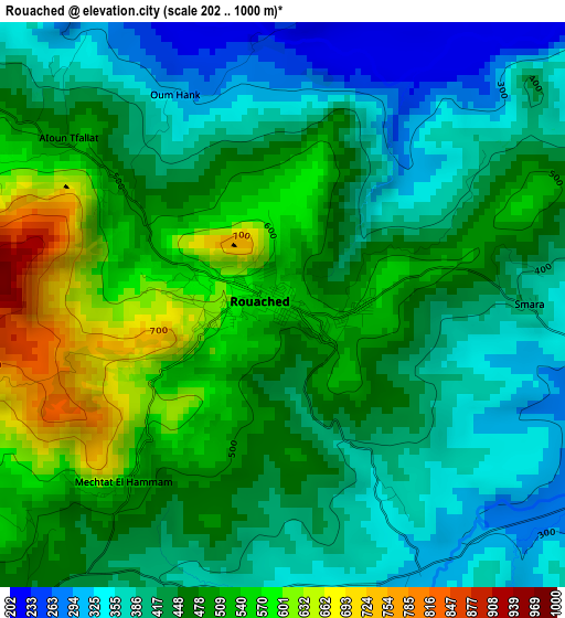
Below is the Elevation map of Rouached, which displays elevation range with different colors. Scale of the first map is from 202 to 1000 m (663 to 3281 ft) with average elevation of 454.5 meters (=1491 ft) [note 1]
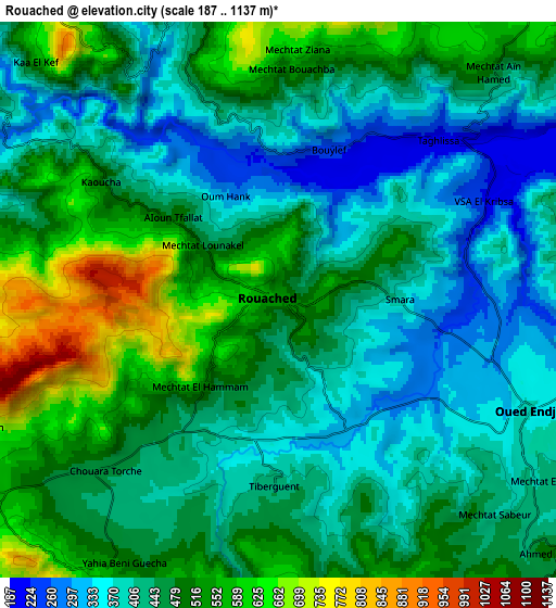
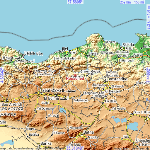
These maps also provides idea of topography and contour of this city, they are displayed at different zoom levels. More info about maps, scale and edge coordinates you can find below images.
| \ | Map #1 | Map #2 | Topo.Map |
| Scale [m] | 202..1000 m | 187..1137 m | × |
| Scale [ft] | 663..3281 ft | 614..3730 ft | × |
| Average | 454.5 m = 1491 ft | 460.9 m = 1512 ft | × |
| Width | 7.86 km = 4.9 mi | 15.72 km = 9.8 mi | 251.5 km = 156.3 mi |
| Height | 7.86 km = 4.9 mi | 15.72 km = 9.8 mi | 251.5 km = 156.3 mi |
| ↑Max Latitude | 36.493077° | 36.528398° | 37.5805° |
| Latitude at center | 36.45774° | 36.45774° | 36.45774° |
| ↓Min Latitude | 36.422387° | 36.387018° | 35.31849° |
| ← Min Longitude | 5.998725° | 5.954779° | 4.63642° |
| Longitude center | 6.04267° | 6.04267° | 6.04267° |
| →Max Longitude | 6.086615° | 6.130561° | 7.44892° |
Nearby cities:
Cities around Rouached sort by population:
• Constantine elevation 574 m
52.2 km,  101°
101°
• Jijel 9 m
47.3 km,  328°
328°
• El Eulma 959 m
46.3 km,  222°
222°
• El Khroub 630 m
62.2 km,  110°
110°
• Chelghoum el Aïd 766 m
34.6 km,  161°
161°
• Mila 470 m
19.9 km,  92°
92°
• Hamma Bouziane 479 m
49.8 km, 95°
• Telerghma 748 m
47.1 km,  143°
143°
• BABOR - VILLE 944 m
45.1 km,  274°
274°
• Aïn Smara 627 m
46.2 km,  117°
117°
• Didouche Mourad 537 m
53.1 km, 90°
• Sidi Mérouane 289 m
20.7 km,  70°
70°
Multilingual:
 En español:
Rouached elevación 543 m.
 En France:
Rouached élévation 543 m.
 Auf Deutsch:
Rouached höhe über dem Meeresspiegel ist 543 m.

Sources and notes:
- [note 1] Map square and city borders are not equal. Map elevation data is calculated only from area inside that square.
- [src 1] Elevation data from geonames database provided with same terms of usage.
- [src 2] The elevation map of Rouached is generated using elevation data from NASA's 3 arcsec (90m) resolution SRTM data.
- [src 3] Base (background) map © OpenStreetMap contributors tiles are generated by Geofabrik and OpenTopoMap.
Copyright & License:
This Rouached Elevation Map is licensed under CC BY-SA. You may reuse any part from this page, if you give a proper credit by linking to this URL:
 More info on terms of use page.