Sidi Akkacha elevation
Sidi Akkacha (Chlef), Algeria elevation is 120 meters and Sidi Akkacha elevation in feet is 394 ft above sea level [src 1]. Sidi Akkacha is a populated place (feature code) with elevation that is 318 meters (1043 ft) smaller than average city elevation in Algeria.
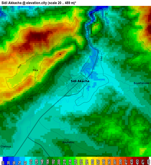
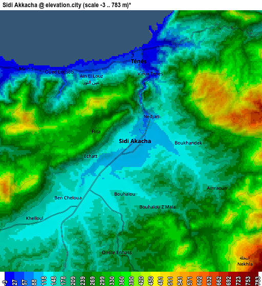
Below is the Elevation map of Sidi Akkacha, which displays elevation range with different colors. Scale of the first map is from 20 to 489 m (66 to 1604 ft) with average elevation of 189.9 meters (=623 ft) [note 1]
These maps also provides idea of topography and contour of this city, they are displayed at different zoom levels. More info about maps, scale and edge coordinates you can find below images.
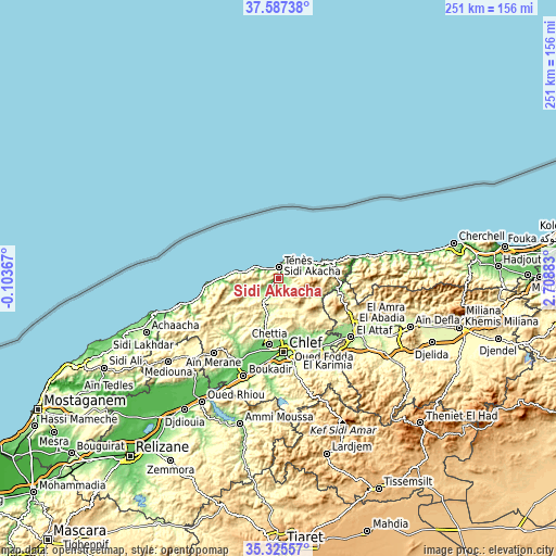
| \ | Map #1 | Map #2 | Topo.Map |
| Scale [m] | 20..489 m | -3..783 m | × |
| Scale [ft] | 66..1604 ft | -10..2569 ft | × |
| Average | 189.9 m = 623 ft | 246.9 m = 810 ft | × |
| Width | 7.86 km = 4.9 mi | 15.72 km = 9.8 mi | 251.5 km = 156.3 mi |
| Height | 7.86 km = 4.9 mi | 15.72 km = 9.8 mi | 251.5 km = 156.3 mi |
| ↑Max Latitude | 36.500054° | 36.535371° | 37.58738° |
| Latitude at center | 36.46472° | 36.46472° | 36.46472° |
| ↓Min Latitude | 36.42937° | 36.394004° | 35.32557° |
| ← Min Longitude | 1.258635° | 1.214689° | -0.10367° |
| Longitude center | 1.30258° | 1.30258° | 1.30258° |
| →Max Longitude | 1.346525° | 1.390471° | 2.70883° |
Nearby cities:
Cities around Sidi Akkacha sort by population:
• Chlef elevation 116 m
33.4 km,  175°
175°
• Ech Chettia 140 m
30.2 km,  188°
188°
• Oued Rhiou 97 m
65.7 km,  211°
211°
• Aïn Defla 264 m
63.6 km,  110°
110°
• Oued Fodda 168 m
37.3 km,  146°
146°
• El Attaf 158 m
42.6 km,  128°
128°
• ’Aïn Merane 504 m
44.9 km,  221°
221°
• Oued Sly 90 m
41.5 km, 192°
• El Abadia 177 m
40.6 km,  122°
122°
• Boukadir 79 m
47 km,  199°
199°
• Abou el Hassan 189 m
10.9 km,  240°
240°
• Mazouna 342 m
52.5 km, 223°
Multilingual:
 En español:
Sidi Akkacha elevación 120 m.
 En France:
Sidi Akkacha élévation 120 m.
 Auf Deutsch:
Sidi Akkacha höhe über dem Meeresspiegel ist 120 m.

Sources and notes:
- [note 1] Map square and city borders are not equal. Map elevation data is calculated only from area inside that square.
- [src 1] Elevation data from geonames database provided with same terms of usage.
- [src 2] The elevation map of Sidi Akkacha is generated using elevation data from NASA's 3 arcsec (90m) resolution SRTM data.
- [src 3] Base (background) map © OpenStreetMap contributors tiles are generated by Geofabrik and OpenTopoMap.
Copyright & License:
This Sidi Akkacha Elevation Map is licensed under CC BY-SA. You may reuse any part from this page, if you give a proper credit by linking to this URL:
 More info on terms of use page.