Villa Consuelo elevation
Villa Consuelo (Nacional, Santo Domingo De Guzmán), Dominican Republic elevation is 50 meters and Villa Consuelo elevation in feet is 164 ft above sea level [src 1]. Villa Consuelo is a section of populated place (feature code) with elevation that is 113 meters (371 ft) smaller than average city elevation in Dominican Republic.
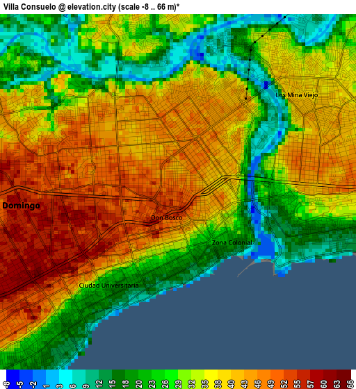
Below is the Elevation map of Villa Consuelo, which displays elevation range with different colors. Scale of the first map is from -8 to 66 m (-26 to 217 ft) with average elevation of 33.8 meters (=111 ft) [note 1]
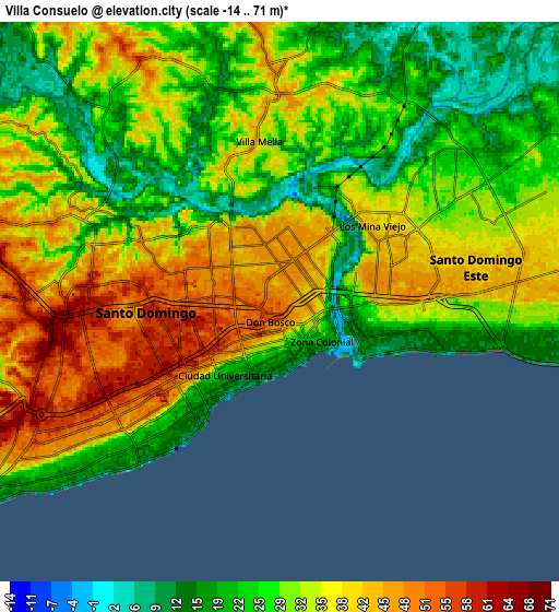
These maps also provides idea of topography and contour of this city, they are displayed at different zoom levels. More info about maps, scale and edge coordinates you can find below images.
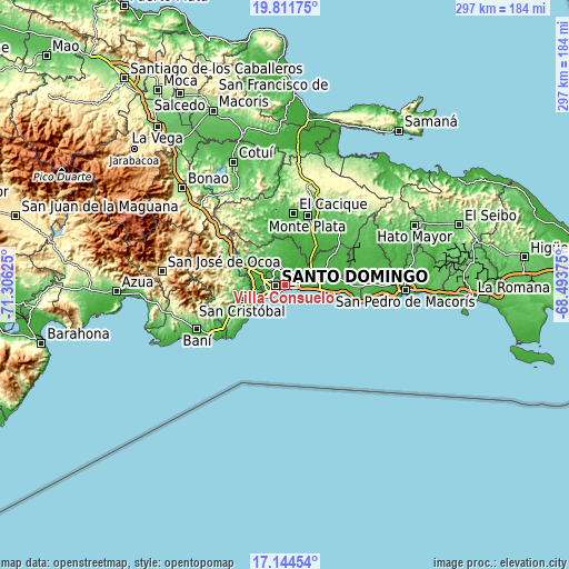
| \ | Map #1 | Map #2 | Topo.Map |
| Scale [m] | -8..66 m | -14..71 m | × |
| Scale [ft] | -26..217 ft | -46..233 ft | × |
| Average | 33.8 m = 111 ft | 31.3 m = 103 ft | × |
| Width | 9.27 km = 5.8 mi | 18.54 km = 11.5 mi | 296.6 km = 184.3 mi |
| Height | 9.27 km = 5.8 mi | 18.54 km = 11.5 mi | 296.6 km = 184.3 mi |
| ↑Max Latitude | 18.525003° | 18.566667° | 19.81175° |
| Latitude at center | 18.48333° | 18.48333° | 18.48333° |
| ↓Min Latitude | 18.441647° | 18.399953° | 17.14454° |
| ← Min Longitude | -69.943945° | -69.987891° | -71.30625° |
| Longitude center | -69.9° | -69.9° | -69.9° |
| →Max Longitude | -69.856055° | -69.812109° | -68.49375° |
Nearby cities:
Cities around Villa Consuelo sort by population:
• Santo Domingo elevation 9 m
1.5 km,  147°
147°
• Santo Domingo Oeste 58 m
10.7 km,  279°
279°
• Santo Domingo Este 46 m
4.6 km,  82°
82°
• Bella Vista 50 m
5.7 km,  237°
237°
• Villa Francisca 42 m
1.1 km,  93°
93°
• Ciudad Nueva 15 m
1.9 km,  158°
158°
• Cristo Rey 31 m
4 km,  297°
297°
• San Carlos 50 m
0 km,  0°
0°
• La Julia 57 m
4 km, 242°
• La Agustina 31 m
4 km, 297°
• Ensanche Luperón 44 m
1.9 km, 0°
• El Carril 60 m
14 km,  254°
254°
Multilingual:
 En español:
Villa Consuelo elevación 50 m.
 En France:
Villa Consuelo élévation 50 m.
 Auf Deutsch:
Villa Consuelo höhe über dem Meeresspiegel ist 50 m.

Sources and notes:
- [note 1] Map square and city borders are not equal. Map elevation data is calculated only from area inside that square.
- [src 1] Elevation data from geonames database provided with same terms of usage.
- [src 2] The elevation map of Villa Consuelo is generated using elevation data from NASA's 3 arcsec (90m) resolution SRTM data.
- [src 3] Base (background) map © OpenStreetMap contributors tiles are generated by Geofabrik and OpenTopoMap.
Copyright & License:
This Villa Consuelo Elevation Map is licensed under CC BY-SA. You may reuse any part from this page, if you give a proper credit by linking to this URL:
 More info on terms of use page.