Salisbury elevation
Salisbury (Saint Joseph), Dominica elevation is 1 meters and Salisbury elevation in feet is 3 ft above sea level [src 1]. Salisbury is a populated place (feature code) with elevation that is 78 meters (256 ft) smaller than average city elevation in Dominica.
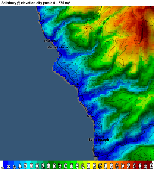
Below is the Elevation map of Salisbury, which displays elevation range with different colors. Scale of the first map is from 0 to 875 m (0 to 2871 ft) with average elevation of 309.1 meters (=1014 ft) [note 1]
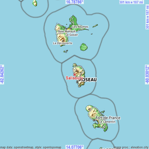
These maps also provides idea of topography and contour of this city, they are displayed at different zoom levels. More info about maps, scale and edge coordinates you can find below images.
| \ | Map #1 | Topo.Map |
| Scale [m] | 0..875 m | × |
| Scale [ft] | 0..2871 ft | × |
| Average | 309.1 m = 1014 ft | × |
| Width | 9.42 km = 5.9 mi | 301.4 km = 187.3 mi |
| Height | 9.42 km = 5.9 mi | 301.4 km = 187.3 mi |
| ↑Max Latitude | 15.479246° | 16.78786° |
| Latitude at center | 15.43689° | 15.43689° |
| ↓Min Latitude | 15.394526° | 14.07706° |
| ← Min Longitude | -61.480315° | -62.84262° |
| Longitude center | -61.43637° | -61.43637° |
| →Max Longitude | -61.392425° | -60.03012° |
Nearby cities:
Cities around Salisbury sort by population:
• Roseau elevation 11 m
15.9 km,  160°
160°
• Portsmouth 15 m
16.6 km,  348°
348°
• Marigot 1 m
19.9 km,  55°
55°
• Mahaut 20 m
9.2 km,  152°
152°
• Saint Joseph 1 m
4.1 km,  175°
175°
• Wesley 90 m
19.3 km,  41°
41°
• Castle Bruce 60 m
19.2 km,  87°
87°
• Woodford Hill 1 m
19.6 km, 35°
• Calibishie 1 m
19.7 km,  28°
28°
• Colihaut 11 m
6 km,  332°
332°
• Rosalie 75 m
19.8 km,  113°
113°
• Pont Cassé 595 m
12.1 km,  130°
130°
Multilingual:
 En español:
Salisbury elevación 1 m.
 En France:
Salisbury élévation 1 m.


Sources and notes:
- [note 1] Map square and city borders are not equal. Map elevation data is calculated only from area inside that square.
- [src 1] Elevation data from geonames database provided with same terms of usage.
- [src 2] The elevation map of Salisbury is generated using elevation data from NASA's 3 arcsec (90m) resolution SRTM data.
- [src 3] Base (background) map © OpenStreetMap contributors tiles are generated by Geofabrik and OpenTopoMap.
Copyright & License:
This Salisbury Elevation Map is licensed under CC BY-SA. You may reuse any part from this page, if you give a proper credit by linking to this URL:
 More info on terms of use page.