Assens elevation
Assens (South Denmark, Assens Kommune), Denmark elevation is 14 meters and Assens elevation in feet is 46 ft above sea level [src 1]. Assens is a seat of a second-order administrative division (feature code) with elevation that is 13 meters (43 ft) smaller than average city elevation in Denmark.
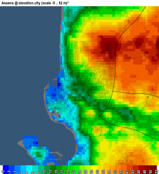
Below is the Elevation map of Assens, which displays elevation range with different colors. Scale of the first map is from -5 to 52 m (-16 to 171 ft) with average elevation of 25.5 meters (=84 ft) [note 1]
These maps also provides idea of topography and contour of this city, they are displayed at different zoom levels. More info about maps, scale and edge coordinates you can find below images.
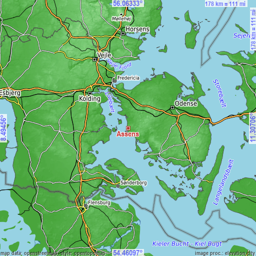
| \ | Map #1 | Map #2 | Topo.Map |
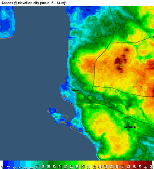
| Scale [m] | -5..52 m | -5..64 m | × |
| Scale [ft] | -16..171 ft | -16..210 ft | × |
| Average | 25.5 m = 84 ft | 25.3 m = 83 ft | × |
| Width | 5.57 km = 3.5 mi | 11.13 km = 6.9 mi | 178.2 km = 110.7 mi |
| Height | 5.57 km = 3.5 mi | 11.13 km = 6.9 mi | 178.1 km = 110.7 mi |
| ↑Max Latitude | 55.295258° | 55.32027° | 56.06333° |
| Latitude at center | 55.27023° | 55.27023° | 55.27023° |
| ↓Min Latitude | 55.245186° | 55.220127° | 54.46097° |
| ← Min Longitude | 9.856865° | 9.812919° | 8.49456° |
| Longitude center | 9.90081° | 9.90081° | 9.90081° |
| →Max Longitude | 9.944755° | 9.988701° | 11.30706° |
Nearby cities:
Cities around Assens sort by population:
• Haderslev elevation 13 m
26.3 km,  264°
264°
• Nordborg 15 m
25.8 km,  203°
203°
• Glamsbjerg 55 m
12.9 km,  88°
88°
• Vissenbjerg 114 m
19.7 km,  49°
49°
• Nørre Åby 23 m
21.3 km,  356°
356°
• Årup 63 m
14.5 km,  37°
37°
• Tommerup Stationsby 59 m
19.3 km,  64°
64°
• Hårby 14 m
15 km,  110°
110°
• Starup 21 m
23.4 km, 262°
• Tommerup 52 m
20.1 km,  74°
74°
• Ejby 25 m
17.9 km,  5°
5°
• Brenderup 11 m
24.3 km, 11°
Multilingual:
 En español:
Assens elevación 14 m.
 En France:
Assens élévation 14 m.


Sources and notes:
- [note 1] Map square and city borders are not equal. Map elevation data is calculated only from area inside that square.
- [src 1] Elevation data from geonames database provided with same terms of usage.
- [src 2] The elevation map of Assens is generated using elevation data from NASA's 3 arcsec (90m) resolution SRTM data.
- [src 3] Base (background) map © OpenStreetMap contributors tiles are generated by Geofabrik and OpenTopoMap.
Copyright & License:
This Assens Elevation Map is licensed under CC BY-SA. You may reuse any part from this page, if you give a proper credit by linking to this URL:
 More info on terms of use page.