Hørning elevation
Hørning (Central Jutland, Skanderborg Kommune), Denmark elevation is 68 meters and Hørning elevation in feet is 223 ft above sea level [src 1]. Hørning is a populated place (feature code) with elevation that is 41 meters (135 ft) bigger than average city elevation in Denmark.
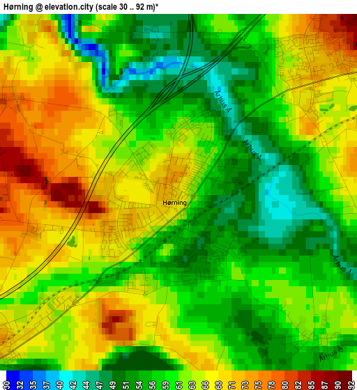
Below is the Elevation map of Hørning, which displays elevation range with different colors. Scale of the first map is from 30 to 92 m (98 to 302 ft) with average elevation of 61.5 meters (=202 ft) [note 1]
These maps also provides idea of topography and contour of this city, they are displayed at different zoom levels. More info about maps, scale and edge coordinates you can find below images.
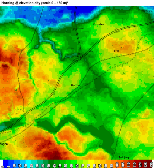
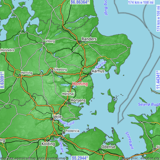
| \ | Map #1 | Map #2 | Topo.Map |
| Scale [m] | 30..92 m | 0..130 m | × |
| Scale [ft] | 98..302 ft | 0..427 ft | × |
| Average | 61.5 m = 202 ft | 64.2 m = 211 ft | × |
| Width | 5.45 km = 3.4 mi | 10.9 km = 6.8 mi | 174.5 km = 108.4 mi |
| Height | 5.45 km = 3.4 mi | 10.9 km = 6.8 mi | 174.5 km = 108.4 mi |
| ↑Max Latitude | 56.111521° | 56.136016° | 56.86364° |
| Latitude at center | 56.08701° | 56.08701° | 56.08701° |
| ↓Min Latitude | 56.062484° | 56.037942° | 55.2944° |
| ← Min Longitude | 9.993215° | 9.949269° | 8.63091° |
| Longitude center | 10.03716° | 10.03716° | 10.03716° |
| →Max Longitude | 10.081105° | 10.125051° | 11.44341° |
Nearby cities:
Cities around Hørning sort by population:
• Skanderborg elevation 38 m
8.8 km,  228°
228°
• Tranbjerg 74 m
6.2 km,  81°
81°
• Kolt 75 m
3.1 km,  40°
40°
• Galten 45 m
10.9 km,  317°
317°
• Beder 46 m
11.2 km,  105°
105°
• Stilling 68 m
4.1 km, 227°
• Stavtrup 35 m
7.1 km,  46°
46°
• Malling 57 m
11.4 km,  119°
119°
• Framlev 39 m
7.9 km,  349°
349°
• Solbjerg 59 m
5.8 km,  148°
148°
• Mårslet 49 m
8 km, 106°
• Skovby 37 m
9.6 km, 323°
Multilingual:
 En español:
Hørning elevación 68 m.
 En France:
Hørning élévation 68 m.


Sources and notes:
- [note 1] Map square and city borders are not equal. Map elevation data is calculated only from area inside that square.
- [src 1] Elevation data from geonames database provided with same terms of usage.
- [src 2] The elevation map of Hørning is generated using elevation data from NASA's 3 arcsec (90m) resolution SRTM data.
- [src 3] Base (background) map © OpenStreetMap contributors tiles are generated by Geofabrik and OpenTopoMap.
Copyright & License:
This Hørning Elevation Map is licensed under CC BY-SA. You may reuse any part from this page, if you give a proper credit by linking to this URL:
 More info on terms of use page.