Horsens elevation
Horsens (Central Jutland, Horsens Kommune), Denmark elevation is 4 meters and Horsens elevation in feet is 13 ft above sea level [src 1]. Horsens is a seat of a second-order administrative division (feature code) with elevation that is 23 meters (75 ft) smaller than average city elevation in Denmark.
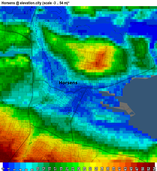
Below is the Elevation map of Horsens, which displays elevation range with different colors. Scale of the first map is from -3 to 54 m (-10 to 177 ft) with average elevation of 14.6 meters (=48 ft) [note 1]
These maps also provides idea of topography and contour of this city, they are displayed at different zoom levels. More info about maps, scale and edge coordinates you can find below images.
| \ | Map #1 | Map #2 | Topo.Map |
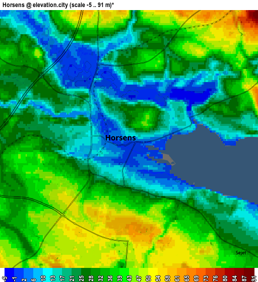
| Scale [m] | -3..54 m | -5..91 m | × |
| Scale [ft] | -10..177 ft | -16..299 ft | × |
| Average | 14.6 m = 48 ft | 29 m = 95 ft | × |
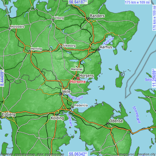
| Width | 5.48 km = 3.4 mi | 10.97 km = 6.8 mi | 175.5 km = 109.1 mi |
| Height | 5.48 km = 3.4 mi | 10.97 km = 6.8 mi | 175.5 km = 109.1 mi |
| ↑Max Latitude | 55.885315° | 55.909954° | 56.64187° |
| Latitude at center | 55.86066° | 55.86066° | 55.86066° |
| ↓Min Latitude | 55.83599° | 55.811304° | 55.06342° |
| ← Min Longitude | 9.806395° | 9.762449° | 8.44409° |
| Longitude center | 9.85034° | 9.85034° | 9.85034° |
| →Max Longitude | 9.894285° | 9.938231° | 11.25659° |
Nearby cities:
Cities around Horsens sort by population:
• Vejle elevation 5 m
25.9 km,  229°
229°
• Skanderborg 38 m
20 km,  14°
14°
• Odder 11 m
22.6 km,  56°
56°
• Hedensted 65 m
13.7 km,  222°
222°
• Ry 38 m
26.1 km,  348°
348°
• Juelsminde 2 m
19.8 km,  148°
148°
• Stilling 68 m
24 km,  20°
20°
• Brædstrup 112 m
19.3 km,  309°
309°
• Solbjerg 59 m
25 km,  35°
35°
• Tørring 58 m
22.9 km,  267°
267°
• Brejning 48 m
24.4 km,  207°
207°
• Hornsyld 59 m
11.6 km,  178°
178°
Multilingual:
 En español:
Horsens elevación 4 m.
 En France:
Horsens élévation 4 m.


Sources and notes:
- [note 1] Map square and city borders are not equal. Map elevation data is calculated only from area inside that square.
- [src 1] Elevation data from geonames database provided with same terms of usage.
- [src 2] The elevation map of Horsens is generated using elevation data from NASA's 3 arcsec (90m) resolution SRTM data.
- [src 3] Base (background) map © OpenStreetMap contributors tiles are generated by Geofabrik and OpenTopoMap.
Copyright & License:
This Horsens Elevation Map is licensed under CC BY-SA. You may reuse any part from this page, if you give a proper credit by linking to this URL:
 More info on terms of use page.