Tønder elevation
Tønder (South Denmark, Tønder Kommune), Denmark elevation is 3 meters and Tønder elevation in feet is 10 ft above sea level [src 1]. Tønder is a seat of a second-order administrative division (feature code) with elevation that is 24 meters (79 ft) smaller than average city elevation in Denmark.
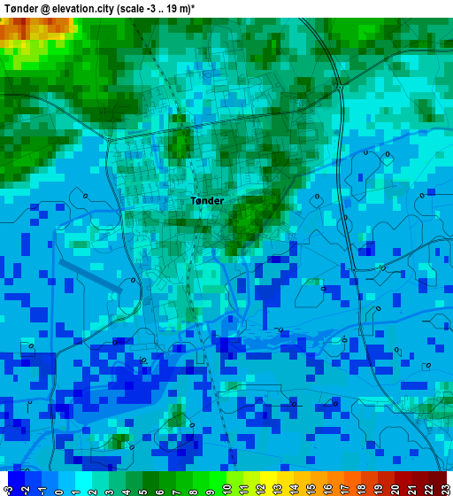
Below is the Elevation map of Tønder, which displays elevation range with different colors. Scale of the first map is from -3 to 19 m (-10 to 62 ft) with average elevation of 1.3 meters (=4 ft) [note 1]
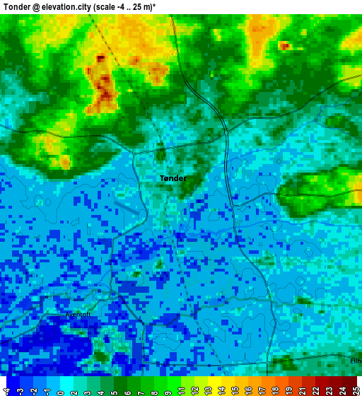
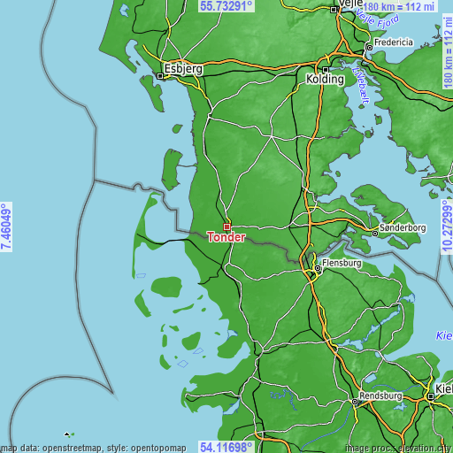
These maps also provides idea of topography and contour of this city, they are displayed at different zoom levels. More info about maps, scale and edge coordinates you can find below images.
| \ | Map #1 | Map #2 | Topo.Map |
| Scale [m] | -3..19 m | -4..25 m | × |
| Scale [ft] | -10..62 ft | -13..82 ft | × |
| Average | 1.3 m = 4 ft | 3.3 m = 11 ft | × |
| Width | 5.61 km = 3.5 mi | 11.23 km = 7 mi | 179.7 km = 111.7 mi |
| Height | 5.61 km = 3.5 mi | 11.23 km = 7 mi | 179.7 km = 111.7 mi |
| ↑Max Latitude | 54.9583° | 54.983524° | 55.73291° |
| Latitude at center | 54.93306° | 54.93306° | 54.93306° |
| ↓Min Latitude | 54.907804° | 54.882532° | 54.11698° |
| ← Min Longitude | 8.822795° | 8.778849° | 7.46049° |
| Longitude center | 8.86674° | 8.86674° | 8.86674° |
| →Max Longitude | 8.910685° | 8.954631° | 10.27299° |
Nearby cities:
Cities around Tønder sort by population:
• Aabenraa elevation 16 m
37.2 km,  70°
70°
• Vojens 42 m
44.7 km,  38°
38°
• Ribe 5 m
44.6 km,  352°
352°
• Rødekro 43 m
33.6 km,  62°
62°
• Padborg 47 m
33.8 km,  110°
110°
• Toftlund 44 m
31.2 km,  24°
24°
• Skaerbaek 16 m
25.7 km, 345°
• Løgumkloster 16 m
15.1 km, 21°
• Tinglev 23 m
24.8 km,  88°
88°
• Gram 36 m
41.3 km, 16°
• Løjt Kirkeby 60 m
41.7 km, 65°
• Kruså 36 m
35.4 km,  104°
104°
Multilingual:
 En español:
Tønder elevación 3 m.
 En France:
Tønder élévation 3 m.
 Auf Deutsch:
Tondern, Tønder höhe über dem Meeresspiegel ist 3 m.

Sources and notes:
- [note 1] Map square and city borders are not equal. Map elevation data is calculated only from area inside that square.
- [src 1] Elevation data from geonames database provided with same terms of usage.
- [src 2] The elevation map of Tønder is generated using elevation data from NASA's 3 arcsec (90m) resolution SRTM data.
- [src 3] Base (background) map © OpenStreetMap contributors tiles are generated by Geofabrik and OpenTopoMap.
Copyright & License:
This Tønder Elevation Map is licensed under CC BY-SA. You may reuse any part from this page, if you give a proper credit by linking to this URL:
 More info on terms of use page.